National Hurricane Center: Tropical depression could develop soon. Will it impact Florida?
In a rush? Here's everything you need to know — in less than a minute — about what's happening in the tropics.
A tropical wave near the Leeward Islands has a medium chance for development this week, according to the latest advisory from the National Hurricane Center.
A tropical depression could develop later this week.
Although the colored area may look like the Hurricane's Center "cone of concern," the orange area on the agency's tropical outlook map actually signifies the area where a tropical cyclone could develop.
Tropical cyclone is the generic term that covers all tropical systems, including tropical depression, tropical storm and hurricane.
Forecasters are encouraging Florida residents to monitor the system carefully.
If the system does strengthen, the next named storm of the season will be Debby.
Here's the latest update from the NHC as of 8 a.m. July 29:
What is a tropical wave?
A tropical wave, also known as an easterly wave, is an elongated area of relatively low pressure that moves from east to west across the tropics. To the west of the system, there is often good weather. To the east, though, cloudiness and heavy rain are often found.
Tropical waves can lead to the formation of a tropical cyclone, according to NOAA.
Tropical wave could become tropical depression this week

An area of disturbed weather over the central tropical Atlantic Ocean is expected to interact with an approaching tropical wave during the next couple of days.
Environmental conditions are forecast to become conducive for some development thereafter, and a tropical depression could form later this week while the system is in the vicinity of the Greater Antilles or the Bahamas.
Formation chance through 48 hours: low, near 0 percent.
Formation chance through 7 days: medium, 50 percent.
What impact can Florida expect from tropical wave?
It's still early to try to determine what impact the tropical wave could have on Florida, but here is what the National Weather Service is currently saying:
South Florida: Ensembles range from a "sloppy" open wave to a named storm, the National Hurricane Center in Miami said. Forecasters advised residents to keep monitoring the National Hurricane Center. At this time, it looks as if the save could approach the area over the weekend. Impacts depend on how close it comes, which is difficult to tell at this time.
East Coast/Central Florida: Models range everywhere from the wave becoming organized on either side of Florida to remaining a wave over the Caribbean. Forecasters at the National Weather Service Melbourne office also said there is a lot of uncertainty yet over the system that's still far away. Best advice is to watch it closely over the week, and have your emergency supplies and plan ready. Potential time for impact in the area could be as early as late Saturday but could be early next week if it slows down.
Southwest Florida: There's no clear guidance right now so the best advice is to always be prepared, especially at this time of year, said forecasters with the National Weather Service, Tampa Bay. Impacts, if any, could arrive over the weekend or early next week.
What else is out there and how likely is it to strengthen?
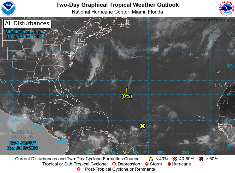
Tropical wave: A tropical wave in the eastern Atlantic is moving west at 17 mph.
What do the colored areas on the NOAA map mean?
The hatched areas on a tropical outlook map indicate "areas where a tropical cyclone — which could be a tropical depression, tropical storm or hurricane — could develop," said National Hurricane Center Deputy Director Jamie Rhome.
The colors make it visibly clear how likely a system could develop with yellow being low, orange medium and red high.
The National Hurricane Center generally doesn't issue tropical advisories until a there is a named storm, but there is an exception.
"If a system is near land and there is potential for development, the National Hurricane Center won't wait before it issues advisories, even if the system hasn't become an actual storm. This gives residents time to prepare," Rhome said.
Who is likely to be impacted?
It's too early at this time to determine if there will be any impact to Florida or the U.S. from the tropical waves.
Forecasters urge all residents to continue monitoring the tropics and to always be prepared. That advice is particularly important for what is expected to be a very active hurricane season.
Weather watches and warnings issued in Florida
When is the Atlantic hurricane season?
The Atlantic hurricane season runs from June 1 through Nov. 30.
When is the peak of hurricane season?
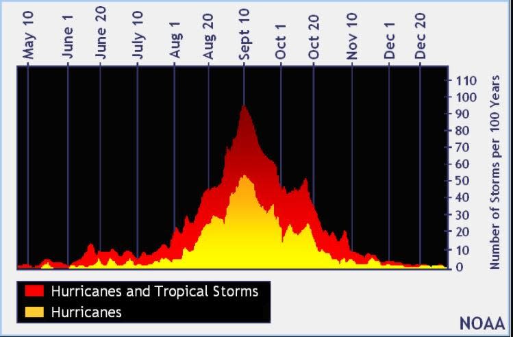
The peak of the season is Sept. 10, with the most activity happening between mid-August and mid-October, according to the Hurricane Center.
National Hurricane Center map: What are forecasters watching now?
Systems currently being monitored by the National Hurricane Center include:
Interactive map: Hurricanes, tropical storms that have passed near your city
Excessive rainfall forecast
What's next?
We will continue to update our tropical weather coverage daily. Download your local site's app to ensure you're always connected to the news. And look for our special subscription offers here.
This article originally appeared on Treasure Coast Newspapers: NHC tracking tropical wave near Windward Islands. Development chances

