NHC issues warning for South Texas as Potential Tropical Cyclone One intensifies. See path
Editor's Note: This file is no longer being updated. Visit the Wednesday file for the latest information.
The tropical disturbance in the Gulf of Mexico south of Texas has intensified, prompting the National Weather Service to issue a tropical storm warning for several areas along Coastal Texas.
The NHC is also expected to name Alberto as the first storm of the 2024 Atlantic hurricane season by Wednesday. To become a tropical storm, maximum sustained winds must reach at least 39 mph.
Currently, the NHC has dubbed the tropical event "Potential Tropical Cyclone One," which allows the NHC to issue advisories, watches and warnings for the system that hasn't yet formed into a tropical storm but poses a threat.
More: Cyclone near Texas has wind speeds to be named a tropical storm. Why hasn't it yet?
More: NHC tracks system in Gulf of Mexico; Jim Cantore warns of 'double digit rainfall' in Texas
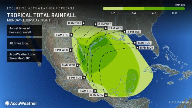
Potential Tropical Cyclone One is expected to make landfall in Mexico late Wednesday but will bring significant rainfall to Texas far earlier, hitting Texas in the coming hours. Those in South Texas and along the coast can expect to see impact as early as Tuesday evening, which will include flooding rain, coastal flooding, gusty winds and high surf and rip currents.
Potential Tropical Cyclone One: Where is it going?

NHC warned that the system is very large, with tropical-storm-force winds extending outward up to 290 miles northeast of the center.
Heavy rain is forecast to extend well north of the center of the storm, spreading into portions of Central Texas. The Weather Channel has forecast rainfall of up to 15 inches in parts of the state, according to the NHC.
Location: 405 miles southeast of Brownsville, Texas
Maximum sustained winds: 40 mph
Movement: north at 6 mph
Pressure: 999 MB
Next advisory: 4 p.m.
Although the disturbance has reached the maximum sustained winds necessary to become a tropical storm, there is still not evidence that a "well-defined center of circulation has developed." According to the NHC, it remains "disorganized" over the western Gulf of Mexico.
Watches and warnings issued in Texas
NHC has issued a tropical storm warning for the Texas coast from Port O'Connor southward to the mouth of the Rio Grande. A warning was also issued for the northeastern coast of Mexico south of the mouth of the Rio Grande to Puerto de Altamira.
Spaghetti models for Potential Tropical Cyclone One
Special note about spaghetti models: Illustrations include an array of forecast tools and models, and not all are created equal. The hurricane center uses only the top four or five highest-performing models to help make its forecasts.
Track Potential Tropical Cyclone One
NHC tracking two other systems
The National Hurricane Center also is monitoring two other systems: a disturbance east of Florida with a low chance for development and another area in the southwestern Gulf of Mexico close to where Potential Tropical Cyclone One is.
Key messages from the National Hurricane Center: What you need to know about Potential Tropical Cyclone One
Users are reminded not to focus on the exact forecast track of this system. The disturbance is very large with rainfall, coastal flooding, and wind impacts likely to occur far from the center along the coasts of Texas and northeastern Mexico.
Rainfall associated with Potential Tropical Cyclone One will impact large regions of Central America, northeastern Mexico and South Texas. This rainfall will likely produce considerable flash and urban flooding along with new and renewed river flooding. Mudslides are also possible in areas of higher terrain across Central America into northeast Mexico.
Moderate coastal flooding is likely along much of the Texas Coast beginning Tuesday morning and continuing through midweek.
Tropical storm conditions are expected beginning Wednesday over portions of the Texas coast south of Port O’Connor, where a Tropical Storm Warning is in effect, and over portions of northeastern Mexico.
What impact could Potential Tropical Cyclone One have and what areas could be affected?
Storm surge: The combination of a dangerous storm surge and the tide will cause normally dry areas near the coast to be flooded by rising waters moving inland from the shoreline. The water could reach the following heights above ground somewhere in the indicated areas if the peak surge occurs at the time of high tide:
Sargent, Texas, to Sabine Pass, Texas: 2-4 feet
Galveston Bay: 2-4 feet
Mouth of the Rio Grande, Texas, to Sargent, Texas: 1-3 feet
Sabine Pass, Texas, to Vermilion/Cameron Parish Line, Louisiana: 1-3 feet
The deepest water will occur along the immediate coast near and to the north of the landfall location, where the surge will be accompanied by large and dangerous waves. Surge-related flooding depends on the relative timing of the surge and the tidal cycle, and can vary greatly over short distances.
Rainfall: Potential Tropical Cyclone One is expected to produce rainfall totals of 5 to 10 inches across northeast Mexico into South Texas, with maximum totals of 15 inches possible. This rainfall will likely produce flash and urban flooding along with new and renewed river flooding. Mudslides are also possible in areas of higher terrain across northeast Mexico.
Wind: Tropical storm conditions are expected within the warning area by Wednesday.
What do tropical storm watches, warnings from NHC mean?
What is storm surge? Graphics explain the deadly weather event
Tropical storm warning: A tropical storm warning means that tropical storm conditions are expected somewhere within the warning area within 36 hours.
Tropical storm watch: An announcement that sustained winds of 39 to 73 mph are possible within the specified area within 48 hours in association with a tropical, subtropical, or post-tropical cyclone.
— USA TODAY NETWORK - Florida reporter Cheryl McCloud contributed to this report.
This article originally appeared on Lubbock Avalanche-Journal: Potential Tropical Cyclone One forms in Gulf of Mexico. Track its path

