NHC map shows most of Texas in Hurricane Beryl's path. Here's how much rain it could bring
Note: This story has been updated to reflect rainfall potential according to the Weather Prediction Center's latest forecast.
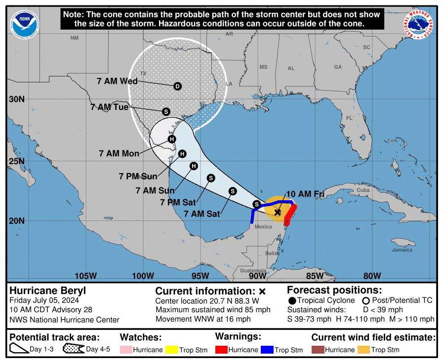
As Hurricane Beryl strengthens once again, it turns toward South Texas. However, most of Texas is now expected to be impacted by the storm, as strong winds and heavy rainfall dominate forecasts.
Entering the Gulf of Mexico, the storm is expected to strengthen as it heads toward northern Mexico and the southern tip of Texas. It remains unclear how far north Beryl will turn, but AccuWeather forecasters say it's possible it will run parallel to the coast before making its third landfall.
People are also reading: Hurricane Beryl likely to strengthen, move toward Texas. See updated maps, projected path
How much rain can Texas expect from Hurricane Beryl? Here's a breakdown by area.
Houston/Galveston: 5 to 10 inches
Rain chances will increase heading into Saturday, cooling temperatures to the mid- to upper 90s. If Beryl's path continues to shift north, the Houston area could see rainfall amounts build fairly quickly, according to the Weather Prediction Center.
Rainfall amounts of 5 to 10 inches with localized amounts of 15 inches is expected across portions of the Texas Gulf Coast and eastern Texas beginning late Sunday through midweek.
Brownsville/Rio Grande Valley: 2 to 6 inches
The southern tip of Texas will see the most severe impact from Hurricane Beryl. Heat indices near 110℉ will pose risks on Friday, followed by wind gusts of 25 to 30 miles per hour Friday afternoon.
Rip current risk is low Friday but will develop into a moderate risk Saturday as the swell period increases, the National Weather Service reports. Heavy rainfall is expected to arrive in South Texas Sunday and into next week.
Mostly normal summer conditions for Saturday. Conditions for Sunday and Monday will depend on the track of Beryl. At minimum, isolated to scattered showers and thunderstorms are expected, but dangerous surf, rip currents, and tidal run-up on the beach are also potential impacts. pic.twitter.com/7smwb6jSwa
— NWS Brownsville (@NWSBrownsville) July 5, 2024
Austin/San Antonio: Multiple inches, heavy rainfall
Heavy rainfall is likely to be the main threat from Beryl for the Austin and San Antonio areas, according to a Friday morning report by the National Weather Service.
The NWS said it's too early to determine rainfall totals for the Austin-San Antonio area next week; however, multiple inches of rain could fall along and near its track. Rain chances will bring much-needed relief to Central Texas as several counties have started to see abnormal to moderate drought conditions, according to Wednesday data by the U.S. Drought Monitor.
Today mostly sunny and hot. Iso tstorms north afternoon. Tstorms possible again Sat. Dry Sun. Rain chances increase as Hurricane Beryl approaches Mon. and continue to mid-week. Heavy rain possible is some places. pic.twitter.com/jNvPjCrs3N
— NWS Austin/San Antonio (@NWSSanAntonio) July 5, 2024
Dallas/Fort Worth: 1 to 3 inches
Though uncertainty continues in the forecast track, strength and speed of Beryl, the NWS predicts a moderate uptick in cumulative rainfall estimates for next week. In general, 1 to 3 inches of rainfall is expected through Thursday night, with lesser amounts west of Highway 281.
11 AM: This was the view from our office a little bit ago looking east! We definitely welcome the rain and the slightly cooler temperatures that will persist through the weekend & early next week. 📷 pic.twitter.com/nWQfqAGGM3
— NWS Fort Worth (@NWSFortWorth) July 5, 2024
This article originally appeared on Austin American-Statesman: How much rain will Hurricane Beryl bring to Texas? See weekend forecast

