Not your ordinary aircraft: NOAA Hurricane Hunter jet is designed to collect weather data
Appearances can be deceiving. While the NOAA Gulfstream IV-SP may look like a charter jet at first glance, this is no ordinary aircraft.
Outfitted with advanced technology, multiple radars, and even instruments which are released from the rear, the Gulfstream IV-SP is a flying workspace for the NOAA Hurricane Hunter team.
Consisting of skilled pilots, researchers, and meteorologists, this team braves the weather in order to gather data on storms before they approach the coast. While NOAA does have planes that fly into a hurricane − this particular aircraft collects data on the path of the storm by flying above and around.
When is the next Florida launch? Is there a launch today? Upcoming SpaceX, NASA, ULA rocket launch schedule in Florida
The National Oceanic and Atmospheric Administration (NOAA) works to have eyes on all angles of storms − even seeing right down to their formation. While satellites in orbit have an unmatched view of weather systems, flying straight into the path of the storm can provide even more data. The Gulfstream IV-SP is deployed over the Atlantic Ocean whenever a storm system starts to form − and the data collected is invaluable, officials said.
NOAA's Gulfstream IV-SP aircraft is ready for Florida hurricane season
The Gulfstream IV-SP aircraft rolled down the runway at NASA's Launch and Landing Facility (formerly the landing site of the Space Shuttle) during a recent media event. It's sleek white body displayed five windows on each side, leading back to engines mounted beyond the wings. Underneath a navy blue tail, which sports the NOAA logo and an American flag, the body jets out further beyond − displaying a peculiar rear.
And this unique rear is not for looks — it serves a important role in collecting storm data. According to NOAA, the Tail Doppler Radar (TDR) provides data on multiple layers of the storm. This 8,000 watt radar system rotates as it collects information on the intensity of storm during the flyby.
NOAA Pilot Danielle Varwig stood by the aircraft dressed in a blue flight suit. Varwig told FLORIDA TODAY the aircraft also has a "a powerful nose radar in the front."
That combined with the unique tail radar "are what really make our aircraft special," Varwig said.
According to NOAA, with the Gulfstream IV-SP flying since 1997, it has observed nearly every hurricane coming from the Atlantic in that time period. It is NOAA's other hurricane hunting aircraft, the P-3 Orion, which surveys questionable weather in the Gulf Coast, as well as the Atlantic Coast.
Nicknamed "Gonzo", after the Muppet character, the Gulfstream IV-SP aircraft plays a serious role throughout hurricane season.
"Onboard we fly with flight directors, meteorologists, and also engineers and technicians. If you go inside, there's just a bunch of racks and computers," Varwig said. "We also have a dropsonde (weather instrument) release at the rear of the aircraft."
This isn't a luxurious ride.
Ahead of and next to every seat onboard are computers or instrumentation which receives and transmits data. Behind each seat is a life vest.
NOAA hurricane hunter plane
What makes Gonzo different from NOAA's other storm chasing aircraft − such as the two P-3 Orion aircraft which actually fly into hurricanes − is that this Gulfstream IV-SP flies above and ahead of the storm to collect data. Varwig told FLORIDA TODAY that the aircraft will fly between 41,000 to 45,000 feet above the ground "collecting a whole bunch of 'meat and potatoes' of information."
This data is relayed to the National Hurricane Center in real time. The data also supports research by the Hurricane Research Division of NOAA's Atlantic Oceanographic and Meteorological Laboratory.
By flying around the storm, the team is able to collect information on not only the intensity but which direction it could travel.
This works to reduce uncertainty,
"We'll fly kind of ahead of where we think the storm is going to go if it's specific targeted areas that the hurricane center has identified to help reduce that uncertainty," said Varwig. This will help narrow down the different models used to finetune a hurricane forecast.
This is especially helpful when it comes to evacuation purposes. Knowing where the storm is most likely to make landfall allows emergency services to know which areas are in danger and should evacuate. "So we're not trying to evacuate the entire eastern seaboard or all of the Caribbean Islands," said Varwig.
The goal is to have all that information to the National Hurricane Center and available by the time of the next updated forecast.
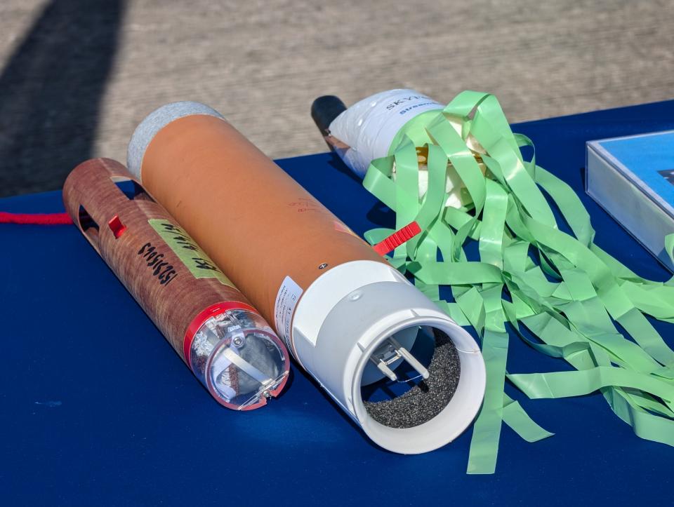
The dropsonde - how NOAA measures hurricane winds
It's not just the sophisticated radars which relay data, the jet also features special single-use instruments known as dropsondes released from the aircraft's rear.
NOAA engineer Nick Underwood compares them to that of a weather balloon. They measure things such as atmospheric pressure and humidity. As the dropsonde falls towards the Atlantic Ocean, it can measure wind speeds, too.
Weighing half an ounce and some with lime-green streamers hanging underneath, these weather tools look almost like party favors. But those plastic streamers are used to effectively stabilize the model, as the body shape gives it the tendency to tumble Inside, it's packed with advanced weather data-collecting technology.
"We'll drop between 20-30 of these all throughout and around the storm, collecting data at those different points. All that factors into the forecast which the Hurricane Center puts together. Where the storm is going to go and how strong its going to be," said Underwood.
Each dropsonde costs about $1,000 and it doesn't survive its fall into the ocean; it's single-use. But Underwood said "the data they are providing is immensely valuable."
They relay data by using a radio transmitter between the 400-and 406 mega-hertz, and the team can usually communicate with up to six per frequency. Some dropsondes use a more advanced software defined radio, giving them the ability to have more channels.
"Part of the operator's job onboard is to make sure this is collecting all the data its supposed to," said Underwood.
With these tools, whenever a storm begins to form near the East Coast, the NOAA Hurricane Hunters are ready to take flight and get as much data as they can.
Brooke Edwards is a Space Reporter for Florida Today. Contact her at bedwards@floridatoday.com or on X: @brookeofstars.
This article originally appeared on Florida Today: Here's the aircraft Hurricane Hunters fly to help predict storm's path

