Oregon wildfires: 17 large fires bring evacuations statewide, more lightning forecast
At least 17 large wildfires and numerous small blazes were burning across Oregon on Friday, bringing evacuation orders in every part of the state, following more than 1,000 lightning strikes earlier in the week.
More than 100 fires were ignited by the lightning strikes Tuesday and Wednesday, and given historically hot and dry conditions, many have grown. Additional lightning strikes forecast for Friday and particularly Saturday could complicate firefighting efforts statewide.
The Pacific Northwest already had 6,000 firefighters working in the field and has become the top priority nationally.
“As critical fire conditions continue this week, multiple agencies are working in concert to protect our state,” Gov. Tina Kotek said.
Here's the latest updates on wildfires burning across the state.
Forecast: Wildfire danger extremely high, only expected to grow with additional lightning
Oregon's wildfire danger was at almost record levels Friday and was likely to stay there into the weekend, said John Saltenberger, fire weather meteorologist for the Northwest Coordination Center.
"We're in the 97% percentile for fire danger," he said. "The forest is ripe for any ignition, be it lightning or human-caused."
The bad news is additional dry lightning was forecast Saturday night into Sunday across western Oregon, but the most of the strikes were expected in southwest Oregon.
Saltenberger said he didn't expect it to be as many strikes as the Tuesday storm — maybe a few hundred — but that it would likely bring additional ignitions.
The silver lining is that once the storm passes, temperatures were forecast to be moderate.
"Fire danger is going to stay near record values Friday-Saturday-Sunday, but then we'll see a pattern change with temperatures dropping cooler and with more humidity," he said. "That works in our favor."
Middle Fork Fire in Crater Lake National Park jumps to 261 acres
The Middle Fork Fire burning northwest of Crater Lake reached 261 acres by Friday morning. Fire crews were engaging the blaze. It was not clear what impact the fire is having on Crater Lake National Park, and the park remained open.
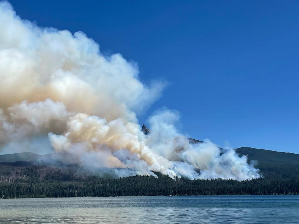
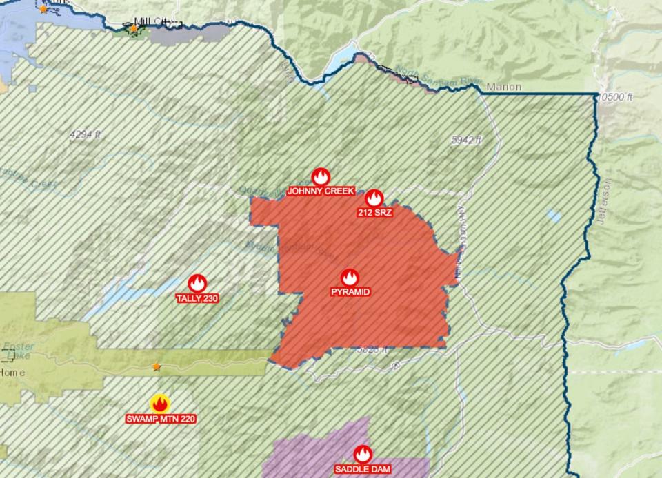
Pyramid Fire grows to 60 acres, brings large level 3 evacuation to Tombstone Pass area east of Sweet Home, south of Detroit
The Pyramid Fire grew to at least 60 acres by Friday morning east of Sweet Home in the Tombstone Pass area north of Highway 20 and south of Detroit near Santiam Junction.
In response, Linn County Sheriff Michelle Duncan issued a level 3 "go now" evacuation order for a large area of the Sweet Home Ranger District that mostly includes hiking trails and campgrounds in the Old Cascades region. The evacuation was coordinated with the U.S. Forest Service, and a closure of the area was likely.
"Sheriff Duncan wants everyone to know that the large evacuation area is necessary to give wildfire response teams enough space to safely travel and fight the fire. The fire itself is much smaller than the evacuation area," a news release said.
No residential structures were in jeopardy of the fire.
View a map of the closure area at tinyurl.com/LinnCoFireMap.
Oakridge evacuation warnings downgraded to level 1
The area east of High Prairie Road milepost 5.5, including Dead Mountain, Mountain View, Huckleberry and High Prairie Loop has been downgraded to level 1 "be ready," as of Friday afternoon.
The northern part of Oakridge remained on level 1 and 2 evacuation warnings Friday morning. In the McKenzie Corridor, the Ore Fire burning near Blue River grew to 440 acres. Here are more details on fires burning in Willamette National Forest east of Salem and Eugene.
The High Prairie Fire, listed at 10 acres, brought a level 2 and level 1 evacuation warnings north of Oakridge. The latest evacuation map can be seen at bit.ly/4bPids2. Another fire, the McKinley Fire, is also north of Oakridge and estimated at 3 acres.
Air quality in Eugene and Oakridge degrades
The air quality in Eugene and Oakridge has degraded from the growing amount of wildfire on Friday morning.
Eugene is now averaging at moderate air quality, which means, air quality is acceptable. However, there may be risk for some people.
Oakridge was degraded to "Unhealthy for Sensitive groups."
The Air Quality Index can be found here, Oregon Department of Environmental Quality
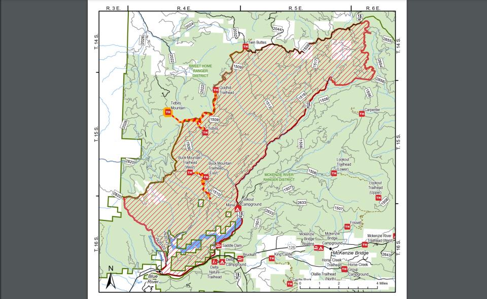
Ore Fire reaches 440 acres in McKenzie Corridor, Blue River Reservoir campgrounds, trails closed
Willamette National Forest issued a closure order around much of Blue River Reservoir due to the 440-acre Ore Fire located north of Rainbow in the McKenzie River corridor.
The closure included the following sites: Buck Mountain Trail, Tidbits South and West Trail, Gold Hill Trail, Mona Campground, Lookout Campground, and Saddle Dam Boat Launch.
A full map and breakdown of the closure can be found at bit.ly/4f2uzQi.
Level 3 evacuation orders remain for Wickiup Reservoir area in Central Oregon
The Round Mountain and Wickiup fires on Deschutes National Forest reached a combined 250 acres by Friday morning, according to Central Oregon Fire Info. Level 2 and 3 evacuation orders were issued around Wickiup Reservoir.
Both fires were expected to remain active given the hot temperatures, although fire crews were making some progress, COFI said.
Evacuation maps can be found at bit.ly/3Wr3y1B.
Cluster of fires southeast of Dorena
There were cluster of fires burning southeast of Cottage Drove and Dorena, including the Lane 1 Fire (250 acres), Adam Mountain Fire (60 acres) and a few others. The impact was unclear.
Evacuation warnings for North Umpqua area due to Boulder Fire/Pine Bench fires near Toketee Falls
A level 2 "be set" evacuation warning was issued due to the Boulder Flat/Pine Bench Fire east of Roseburg and Glide in the North Umpqua Canyon near Toketee Falls. The evacuation was for homes in the Slide Creek area downstream to the Soda Springs area due to a fire near Soda Springs and Pine Bench in Toketee.
The fire was listed at roughly 250 acres Friday morning. A map of the evacuation area can be found here: bit.ly/4dc3qsB.
Rogue River fires mostly snuffed out
In a bit of good news, fire crews reported keeping the wildfires ignited in the famed Rogue River Canyon small and they appeared to be under control, according to the Oregon Department of Forestry.
Fire crews hiked into rugged terrain, and hot shots dropped into the canyon, to keep one of Oregon's most popular rafting rivers open.
Fire restrictions in place for Willamette and Siuslaw national forests, majority of places in Oregon
The majority of Oregon's national and state forests outlawed campfires, except in campgrounds.
Willamette National Forest and Siuslaw national forests, to the east and west of the Willamette Valley, implemented fire restrictions this week.
Fire restrictions prohibit all campfires, charcoal or briquette fires, pellet fires or other open fires outside of designated campgrounds. Building, maintaining or using a fire, campfire or stove was still permitted in designated metal campfire rings or grills in designated recreational sites.
Restrictions for smoking, off-highway vehicles and chainsaws in campgrounds were also in effect.
Restrictions and updates to restrictions as they change can be found at fs.usda.gov/main/willamette/fire.
Eastern Oregon wildfires
There were numerous large active wildfires burning on the east side of the state.
Deteriorating air quality east of the Cascades
Air quality was moderate to poor east of the Cascades Friday morning, with numerous fires burning across the state's east side.
Bend's air quality was "moderate" while Burns was at "unhealthy," according to air quality metrics from around the state.
Oregon's west side was in decent shape and that appears likely to remain in place Friday.
An air quality map can be found at aqi.oregon.gov/
Gov. Tina Kotek invokes Conflagration Act for fires in Umatilla County
Kotek invoked the Emergency Conflagration Act for a series of fires in Umatilla County near Pilot Rock late Wednesday night. The Oregon State Fire Marshal is mobilizing its Green Incident Management Team to protect homes in the area.
The Pilot Rock Fire is the largest of the blazes at 10,000 acres but there are a number of other fires in the area as well, including the NF Owens Fire at 952 acres.
"Significant lightning storms moved through Umatilla County Wednesday afternoon and have kept local fire agencies busy responding to wildfires. Gusty winds and dry conditions caused some of these fires to grow exponentially and threaten life and property," a news release said.
Oregon State Fire Marshal requests aid from California to fight Falls Fire
The Oregon State Fire Marshal requested help from California to protect life and property against the growing Falls Fire in Harney County on Friday morning.
California Governor's Office of Emergency Services provided three strike teams with 15 fire engines and 80 firefighters from nine different counties to provide structural protection.
“A huge thanks to California Governor's Office of Emergency Services for sending these resources,” the news release said. “The OSFM has strong relationships with our neighboring states. We're always ready to help when each other is in need.”
The Falls Fire in Grant and Harney counties about 13.5 miles north of Burns reached 110,674 acres by Friday morning and was at 5% containment.
Level 1, 2 and 3 evacuation orders remained in place in Grant and Harney counties. The Harney County Sheriff’s evacuation map can be found at bit.ly/4d1XvX2 for the most accurate evacuation notices.
Ten residences and 13 "other" structures were destroyed in the early stages of the fire, according to Oregon State Fire Marshal structure teams.
This fire forced the closure of several areas in the Malheur National Forest. Emigrant Creek Campground, Falls Campground, Yellowjacket Campground and Delintment Lake Campground were all closed.
Larch Creek Fire appears to slow, containment increased
The Larch Creek Fire grew rapidly in Wasco County to an estimated at 84,00 acres and 40% containment as of Friday morning.
Firefighters had fully lined the perimeter.
Wasco County Sheriff's Office lifted some evacuation orders and reopened Pine Hollow Reservoir and asked the public, "to recreate safely and stay aware of current fire evacuation orders. All evacuations will remain in place today and re-evaluated tonight at 6 p.m."
Evacuation orders at levels 1, 2 and 3 remained in place. An evacuation map can be found at bit.ly/4bPdmae.
Zach Urness has been an outdoors reporter in Oregon for 16 years and is host of the Explore Oregon Podcast. Urness is the author of “Best Hikes with Kids: Oregon” and “Hiking Southern Oregon.” He can be reached at zurness@StatesmanJournal.com or (503) 399-6801. Find him on X at @ZachsORoutdoors.
This article originally appeared on Salem Statesman Journal: Oregon wildfires: 17 large fires bring evacuations statewide

