Oregon wildfires: Forecast mellows for state's 38 fires, but where will smoke settle?
This story was updated at 1:50 p.m. Thursday
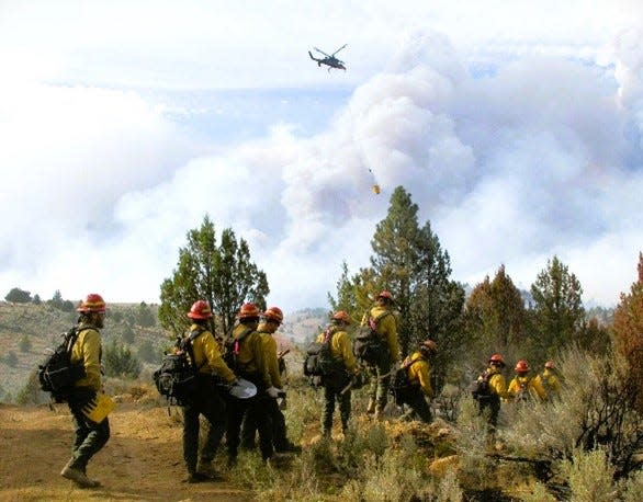
After a period of extreme fire growth and new ignitions, Oregon’s wildfire forecast should moderate somewhat over the coming week, especially on the west side of the state.
Cooler weather, higher humidity, no thunderstorms and the possibility of light rain next week should “retard the growth of existing fires,” said Northwest Coordination Center fire meteorologist John Saltenberger.
If the rain does arrive, it won't be much and wouldn't put out the fires. It would just bring a “pause,” he said, but it's better than conditions have been over the past two weeks.
On the east side of the state — where Oregon’s largest fires are burning — the situation is only slightly improved.
“There’s some relief in temperature and higher humidity, but it’s still dry and we’ll have occasionally breezy conditions,” Saltenberger said. “We don’t have the risk of new fires but there could be some growth of existing ones.”
The only downside to the cooler and more humid weather is that it makes creating containment lines a bit tougher for fire crews that are using controlled fire around the perimeter of blazes.
What about the Oregon smoke forecast?
A westerly wind pushed smoke mostly into central and eastern Oregon Thursday morning, and that trend should continue, Saltenberger said.
Air quality was good across the length of western Oregon Thursday morning, and moderate most places east of the Cascades.
Saltenberger said northwest Oregon was likely to continue seeing good air quality while southwest Oregon may eventually see its air quality degrade.
An air quality alert remains in place for the Roseburg and Umpqua area down to Klamath Falls, along with Bend and most places east of the Cascades.
38 large wildfires burn across Oregon
As of Thursday morning, Oregon has 38 large uncontrolled wildfires burning a total of 950,000 acres, already the most since 2020 with two months of fire season remaining.
Most of the largest have been massive grass fires on the east side of the state, but it's still a significant number.
Here is the latest on the wildfires burning across Oregon.
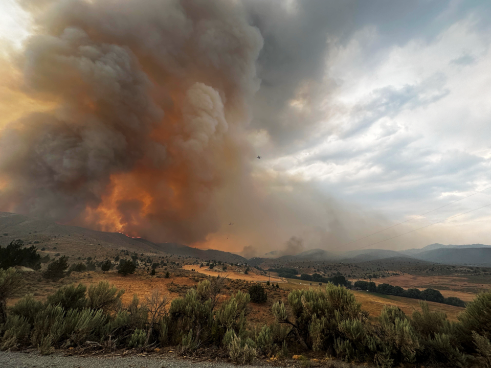
Durkee Fire in eastern Oregon is one of the biggest fires burning in the United States
As of Thursday morning, the fire was reported to be at least 270,000 acres and is 0% contained. The National Weather Service said storms brought close to 3,000 lightning strikes in the area.
Due to weather conditions like lower temperatures and probable thunderstorms, moderate fire behavior is expected on Thursday. Priorities are containment in the Bridgeport, Shirttail Creek Road and Rye Valley Area.
Wednesday's weather was full of erratic winds, lightning and flash flood warnings. Back-to-back thunderstorms with 45-mile-per-hour gusts were present at higher elevations, the news release said. The conditions caused spot fires, but firefighters had a lot of success in catching them.
A half inch of rain hit some areas of the fire's footprint and debris flows are expected.
The Oregon Department of Transportation closed Interstate 84 from Pendleton to Ontario on Wednesday due to unpredictable fire activity in the area. ODOT does not have an expected opening and travelers should not plan to use I-84 for travel. Check TripCheck for updates.
The area was under a red flag warning, hurricane force winds and a flash flood warning, according to the Durkee Fire updates.
Due to the immense heat the Durkee Fire is creating and the existing winds, it is creating its own storms and changing the overall wind patterns.
"We call those pyrocumulus and you end up with a thunderstorm over the fire because there's so much heat and just enough moisture above the fire to get a storm that forms," Mike Cantin, a meteorologist from the National Weather Service in Boise, Idaho, said.
This happens due to the air surrounding the fire being drawn toward the fire creating erratic winds in the area. The gusty winds created could spread to other areas and elevate the danger for firefighters.
"The low elevation fuels, all the grass, the sagebrush, all of the trees below 6,000 feet are ready to burn. Any ignition source no matter how small can start another major wildfire," Cantin said.
The Durkee Fire experienced growth on Tuesday due to lightning ignitions over the weekend. This led to temporary closures of Interstate 84 in eastern Oregon for a majority of Tuesday.
On Saturday, Gov. Tina Kotek invoked the Emergency Conflagration Act for the fire.
“The wildfires in Eastern Oregon have scaled up quickly,” Kotek said in a new release on Wednesday. “We are facing strong erratic winds over the region that could impact all fires. Rain is not getting through. Some communities do not have power. The situation is dynamic, and the teams on the ground are taking it day by day. I have deployed resources from the National Guard that are currently serving eastern and southwestern Oregon. I know these communities are supporting one another, doing their part to heed the guidance from officials and showing tremendous gratitude for our firefighters.”
On Friday, the Oregon State Fire Marshal sent structural protection resources in the form of firefighters and equipment to fight the fire in Eastern Oregon.
The fire was first reported last Wednesday and sparked by lightning strikes. The fire has brought level 1, 2 and 3 evacuations around Baker County. An evacuation map can be found at bit.ly/3YaNUJ0
"If you are outside, don’t create any sparks. Don’t drag a chain, if you are driving an RV make sure your chains are tied up, don’t park your car over grass, the heat of the engine could ignite it," Cantin said. "This is one of those critical situations, that’s why fire are getting so big the weather is just right and the grass and sage and trees are ready to burn, all it takes is just a little bit."
California Incident Management Team 5 to take command of Slate Fire
Due to unprecedented amount of fire activity, CIMT 5 will take command of Slate Fire, the news release said.
The fire is south of the Detroit Reservoir and has burnt 50 acres with 0% containment as of Thursday morning. The terrain is in a heavily forested area, steep and inaccessible. On Thursday, crews will use dozers to establish a control line with aviation intervention available if needed.
A multi-agency response performed suppression activities over Tuesday night. An air attack took place Wednesday.
Forest Service Road 2212 will be closed from the dam to FS Road 1133 intersection to assist emergency crews’ access.
There were no evacuation orders as of Thursday morning. A list of closures for the Willamette National Forest can be found at bit.ly/4fueUts
Boneyard Fire reaches 52,546 acres at 3% containment
A level 3 "Go Now" evacuation order has been issued in Monument and from the south Morrow County line, north to Forest Service Road 21 and to the east Morrow County line for the Boneyard Fire in northeastern Oregon.
Evacuations include, but are not limited to:
Monument
All of Rudio Road
All of Cottonwood Road
All of Courtrock Road
All of Lost Hubcap Road
Highway 395 north of Trout Road. All of County Road 21/Trout Road, Forest Road 3980, and Forest Road 3969. All of Bully Creek Lane
West of Highway 395 from Porter Lane to the Umatilla County line and north of Highway 402 from Monument to Dust Road.
North from Forest Service Road 21 to the approximate intersection of Forest Service Road 21 and Forest Service Road 2104 and East from Board Creek Road to the East Morrow County line
A link to an interactive evacuation map can be found at bit.ly/4c23PwF
The fire was reported to be 52,546 acres and 3% contained as of Thursday.
Firefighters saw increased activity due to gusting wind and lightning strikes from thunderstorms on Wednesday evening.
There is potential for the Boneyard Fire to merge with the 56,139-acre Monkey Creek Fire to the east.
An evacuation center has been set up at Grant Union High School (911 S Canyon Blvd., John Day).
A community meeting for the fire is planned 6 p.m. Thursday at the Long Creek High School gym (375 E Main St., Long Creek)
Rocky Mountain Complex grows
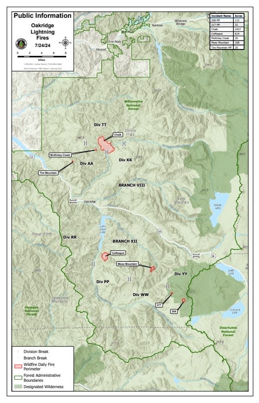
The lightning storm on July 17 ignited seven wildfires to the north, south and southeast of Oakridge and Westfir. The seven fire have totaled 4,425 acres as of Thursday morning.
The Rocky Mountain Complex Incident Team 1 assumed command of the fires on Tuesday.
Fire suppression efforts are underway beginning with fires deemed highest priority — Chalk, Coffeepot and Moss Mountain fires.
The Chalk Fire is the largest of the complex at 2,701 acres and 0% containment. Infrared flights on Tuesday revealed the fire grew by 1,000 acres. The Chalk Fire shares a perimeter with the 2021 Gales Fire scar, which should slow progress and help crews contain the flames.
The rest of the fires in the complex are:
208: 138 acres, 0% contained
217: 37 acres, 0% contained
Coffee Pot Fire: 1,312 acres, 0% contained
McKinley: 27 acres, partially contained
Moss Mountain: 190 acres, 0% contained
Tire Mountain: 20 acres, partially contained
There are no evacuations in place. There are closures on the vicinity of effected areas. Closure information and maps can be found at https://www.fs.usda.gov/detail/willamette/alerts-notices/?cid=fseprd552029
Lane 1 Fires consist of seven fires totaling 4,620 acres
The Lane 1 fires are:
Lane 1- 1296 acres
Clark 900- 929 acres
Quartz- 683 acres
Jack Saddle- 885 acres
Puddin-130 acres
Adam Mountain- 211 acres
Mineral- 482 acres
The specific 1,496-acre Lane 1 fire is 10% contained while the other six are at 0% as of Thursday morning.
Crews will continue working to establish fire line to stop the spread of Lane 1, Jack Saddle, Quartz and Clark 900 fires. Accessibility and available resource have caused a challenge in suppressing the Adam Mountain, Mineral and Puddin fires.
A “Level 1” Evacuation notice has been issued by the Lane County Sheriff’s Department for areas east of Disston starting at Brice Creek Road milepost 0.7 and following Brice Creek Road south. An evacuation map is available at: www.LaneCountyOR.gov/Lane1Fire
Progress made on establishing control line around perimeter of Pyramid Fire
The lightning-caused Pyramid Fire burning east of Middle Santiam Wilderness in the Tombstone Pass area north of Highway 20 and south of Detroit near Santiam Junction has grown to 615 acres and was 0% contained as of Thursday morning.
On Wednesday, Crews and heavy equipment made significant progress toward the clearing of vegetation, opening of roads and establishment of a control line around the fire's perimeter, the news release said. Western winds caused a 3-to-5-acre spot fire on the southeast flank. Crews quickly extinguished the new blaze.
Today, crews plan to work the east and west flanks to complete a control line around the fire's perimeter.
Due to the fire burning in an old-growth forest, fire behavior specialist Jeff Shelton does not anticipate significant fire activity to occur in the next three days. The light wind is causing the smoke to behave like a lid holding the fire's activity.
"Please be mindful of firefighting equipment when driving in the area," the news release said. "Refer to the emergency closure order for forest roads affected by the Pyramid Fire. For information about all other roads, visit the Oregon Department of Transportation website at https://tripcheck.com"
The Linn County Sheriff's Office announced Monday night "There is still no imminent danger to structures, the town of Sweet Home, or of closures to Highway 20" despite the fire behavior and dangerous conditions.
Linn County Sheriff Michelle Duncan issued a level 3 "go now" evacuation order for a large area of the Sweet Home Ranger District that mostly includes hiking trails and campgrounds in the Old Cascades region. The evacuation was coordinated with the U.S. Forest Service, and a closure of the area was likely. View a map of the closure area at tinyurl.com/LinnCoFireMap.
Ore Fire continues to grows amid rugged conditions and extreme fire behavior
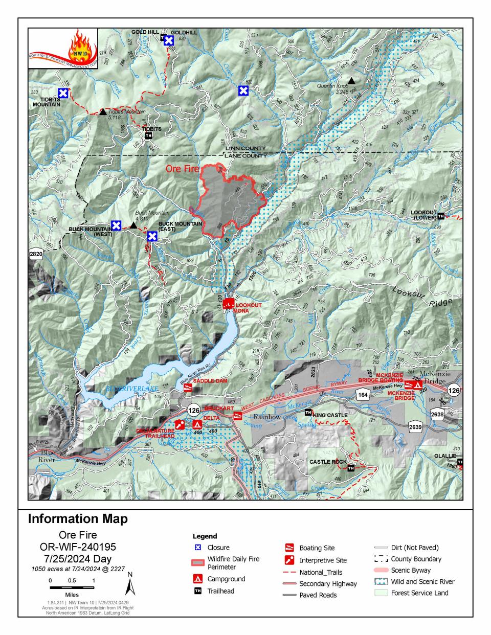
The Ore Fire burning 7 miles northeast of Blue River was burning 1,050 acres as of Thursday morning.
On Wednesday, Crews secured and kept an eye out for any slopovers— fire that crossed over established control line. Although fire activity increased, aviation was available to cool hotspots.
On Thursday, firefighters will establish hose lines and sprinklers along FS Road 15. Increased activity is expected in the afternoon.
Fire managers are focusing on activities with the highest probability of success and least amount of risk to firefighters, communities and resources. The rugged and steep terrain, falling rocks, rolling debris, fire-weakened trees and extreme weather conditions continue to pose safety challenges for crews.
Buck Mountain Trail, Tidbits South and West Trail, Gold Hill Trail, Mona Campground, Lookout Campground and Saddle Dam Boat Launch are closed.
Other closures in the Willamette National Forest due to fire-impacted areas can be found at bit.ly/4dcWMCl
235 personnel engage in full suppression as Homestead Complex reaches 1,044 acres
The Homestead Complex Fire, a group of fires in the Umpqua National Forest, had a combined 1,044 acreage total Thursday morning. Suppression resources and tactics are prioritized by threat to property, infrastructure, industry and areas with highest chance of success.
Crews were working to build containment lines on the 288-acre the Horse Heaven Creek Fire, the most active in the complex.
The steep and rugged terrain of the 317-acre No Man Fire makes it difficult to get firefighters on the ground near the fire's edge. Crews will use roads north of Chilcoot Mountain to establish a containment line around the fire.
As of Thursday, containment lines are being established in areas with highest probability of success for the 104-acre Reynolds Butte Fire.
The 54-acre Fuller Lake Fire and 114-acre Bullpup Fire will remain unstaffed until resources become available.
Weather is predicted to be cooler with a light wind which may moderate fire activity.
The Umpqua National Forest issued closures for all of the Cottage Grove Ranger District and parts of the Diamond Lake, North Umpqua and Tiller ranger districts. Boulder Flat Campground and Boat Launch are closed under the order.
Favorable weather helps crews fighting Microwave Tower Fire near Mosier
Crews were able to make progress by establishing lines on the east end and containing 14% of the 704-acre fire, as of Thursday morning.
The fire has continued to creep down a north-facing ridge along I-84 and west of Mosier.
Authorities estimated 100 homes under level 3 and 500 residents were threatened in the Mosier area. Residents in Mosier west of the Columbia Gorge were being asked to evacuate due to the Microwave Tower Fire, which is being driven by strong winds.
Here are the evacuation levels for areas in Mosier related to the fire:
Level 3 “go now”: From Highway 30 south of Proctor Road, east to Huskey Road and the border of Mosier and west to the Hood River County line.
Level 2 “get set”: Mosier and from Huskey Road east to Mosier Creek Road and south to Jasper Lane.
Level 1 “be ready”: From Mosier Creek Road, east to Dry Creek Road, north to Mosier border and south to Osborn Cutoff Road.
There is a Red Cross shelter available for evacuees at Hood River Middle School, 1602 May St.,, Hood River, OR., 97031.
The fire started Monday afternoon west of Rattler Ridge west of Mosier.
The fire is burning in grass and timber and was being pushed eastwards by strong westerly winds.
For info on evacuation levels, go to the Wasco County Sheriff’s Office Facebook page: https://www.facebook.com/WascoCountySheriff/
23 fires burn at least 4,146 acres in the Diamond Complex
Twenty three fires were burning at least 4,146 acres on the Diamond Complex as of Thursday morning. The complex is 3% contained. Firefighters are directly attacking the fire's edge where access and safety allow. Indirect strategies— using constructed control lines and natural barriers— have been implemented where safety concerns prevent direct attacks.
All fires are under a full suppression strategy with firefighters directly attacking the fire line where feasible.
These are the active fires in the complex:
Pine Bench: 1,546 acres at 0% containment (north of Highway 138 near Dry Creek)
Trail: 830 acres at 5% containment (east of Highway 138 on the west slope of Mount Thielsen)
Lemolo: 627 acres at 0% containment (north of Lemolo Lake on Bunker Hill)
Pig Iron: 27 acres at 25% containment (Pig Iron Mountain north of Highway 138)
Watson: 166 acres at 0% containment (north of Highway 138 on Watson Ridge)
Brodie: 98 acres at 0% containment (about 5 miles south of Highway 138 and south of Devils Canyon)
Trep: 109 acres at 0% containment (about 4 miles south of Highway 138)
Garwood: 5 acres at 65% containment (about 3 miles southwest of Mount Bailey)
Slide: 0.1 acres at 90% containment (northeast of Pine Bench)
Potter: 504 acres (north of Highway 138 about 2 miles southeast of Potter Mt.)
Ooya: 136 acres (north of Highway 138 about 1 mile northeast of Bird Point)
Clearwater: 1 acre at 90% containment (south of Highway 138 about 5 miles northwest of Diamond Lake)
Elephant: .07 acres at 0% containment (2 miles southwest of Lemolo Lake)
Lost Bear: 5 acres at 0% containment (2 miles south of Hwy 138)
Lost: 14 acres at 0% containment (4 miles south of Hwy 138)
Loafer: 24 acres 0% contained (one-half mile north of Watson Ridge)
Sheep: .3 acres and 0% contained (3 miles north of Diamond Lake)
Thin: 1 acre and 0% contained (four miles northwest of Diamond Lake)
Trap: 4 acres and 0% contained (1 mile south of Hwy 138 near Trap Mountain)
Bear Trap: 45 acres and 0% contained (2 miles south of Hwy 138 near Bear Trap Mountain)
Campwood: 8 acres and 0% contained (2 miles south of Hwy 138)
Rough: 8 acres and 0% contained (two miles south of Hwy 138)
The two newest fires, totaling nine acres, have not been named. They are burning on north and south of Hwy 138.
A level 2 "be set" evacuation warning was issued due to the Boulder Flat/Pine Bench Fire east of Roseburg and Glide in the North Umpqua Canyon near Toketee Falls. The evacuation was for homes in the Slide Creek area downstream to the Soda Springs area due to a fire near Soda Springs and Pine Bench in Toketee. A map of the evacuation area can be found here: bit.ly/4dc3qsB.
The weather on Tuesday was forecast to be lower in relative humidity and slightly higher in temperature. The conditions will support increased fire spread and spotting potential. This will add to the challenging fire behavior due to rugged and steep terrain.
Lemolo Fire reaches 518 acres in Douglas County
The Lemolo Fire in Douglas County had reach 518 acres as of Thursday morning and was 0% contained.
The Douglas County Sheriff's Office on Saturday night issued level 3 "go now" and level 2 "be ready" evacuation orders for the Lemolo Fire. The fire was reported to be at least 373 acres as of Sunday night.
Level 3 evacuations were issued for:
Bunker Hill Campground
Kelsay Valley Campground
The North Umpqua Trail between USFS 2612 Road and Windigo Pass intersection, west to North Umpqua Trail as it intersects with USFS 2612 Road.
This includes all areas on north and northeast side of Lemolo Lake, according to the sheriff's office.
Level 2 evacuation orders have been issued for:
East Lemolo Campground
USFS 2614 Road south of Inlet Campground, including Kelsay Valley, Pumice Flat and Elbow Butte areas.
Poole Creek Campground/Boat Ramp
Lemolo KOA Campground
An evacuation map can be found at www.dcso.com/evacuations
Find more info at the Diamond Complex Fire Information
Falls Fire reaches 140,422 acres and 50% containment in Grant and Harney counties
The Falls Fire burning in Grant and Harney counties near Burns was 140,422 acres and was 50% contained as of Wednesday morning.
A cold front bringing wind and thunderstorms is anticipated to hit the Falls Fire area on Wednesday evening.
The fire was reported to be active on Monday afternoon due to southwest winds, which prompted growth along parts of the northern perimeter of the fire, according to the Tuesday morning update.
On Tuesday, Oregon State Fire Marshal crews were set to remain active on the northeast, east and southern parts of the fire.
The Oregon State Fire Marshal requested help from California to protect life and property against the fire on Friday.
The California Governor's Office of Emergency Services provided three strike teams with 15 fire engines and 80 firefighters from nine different counties to provide structural protection.
Level 1, 2 and 3 evacuation orders remained in place in Grant and Harney counties. The Harney County Sheriff’s evacuation map can be found at bit.ly/4d1XvX2 for the most accurate evacuation notices.
Ten residences and 13 "other" structures were destroyed in the early stages of the fire, according to Oregon State Fire Marshal structure teams.
This fire forced the closure of several areas in the Malheur National Forest. Emigrant Creek Campground, Falls Campground, Yellowjacket Campground and Delintment Lake Campground were all closed.
Round Mountain, Wickiup fires burn in Central Oregon
The Round Mountain and Wickiup fires on Deschutes National Forest remained at a combined 276 acres as of Thursday morning. The Wickiup Fire is now 70% contained and Round Mountain is at 25%.
Crews were set to continue mop up for hot spots and secure the perimeter for both fires on Tuesday.
Evacuation maps can be found at bit.ly/3Wr3y1B.
Parts of Oregon see 75 days without rain as fires rage
As more than a dozen fires burned on national forestland in the Pacific Northwest, some areas have gone more than 75 days without rain as of Tuesday morning, according to the U.S. Forest Service.
The record dryness was partly due to the lack of moisture in the Pacific Northwest. The Fremont-Winema and Deschutes national forests had gone more than 75 days without rain.
The Rogue River-Siskiyou National Forest in southern Oregon and Wallowa-Whitman in the east had both gone at least 45 days without rain, as has the Okanogan-Wenatchee.
he lightning storms last week produced more than 2,000 strikes in 48 hours, causing rapid wildfire growth in already dry timber regions.
“This is shaping up to be another monster fire year in the Pacific Northwest, and it’s just mid-July,” said Ed Hiatt, Pacific Northwest assistant fire director for operations.
Every year, 75% of wildfires are human-caused, according to the Forest Service. In an effort to reduce this, all 17 national forests in the region were in campfire restrictions.
Temperatures were expected to cool by the end of the week, but the lack of moisture was expected to continue to keep forests and grasslands at critical fire conditions, the Forest Service said.
Campfires prohibited on BLM public lands in Northwest Oregon District
Campfires are now prohibited on all Bureau of Land Management public lands throughout the Northwest Oregon District.
Fires, campfires, smoking in vegetated areas, using vehicles in unmanaged vegetated areas, operating a chainsaw, welding, cutting or grinding, or using an internal combustion engine without a spark arrestor will be prohibited. The BLM announced Monday these stronger restrictions will remain in effect until rescinded.
More information on restrictions and closures can be found at blm.gov/orwafire
Fire restrictions in place for Willamette and Siuslaw national forests, majority of places in Oregon
The majority of Oregon's national and state forests outlawed campfires, except in campgrounds.
Willamette National Forest and Siuslaw national forests, to the east and west of the Willamette Valley, implemented fire restrictions this week.
Fire restrictions prohibit all campfires, charcoal or briquette fires, pellet fires or other open fires outside of designated campgrounds. Building, maintaining or using a fire, campfire or stove was still permitted in designated metal campfire rings or grills in designated recreational sites.
Restrictions for smoking, off-highway vehicles and chainsaws in campgrounds were also in effect.
Restrictions and updates to restrictions as they change can be found at fs.usda.gov/main/willamette/fire.
BLM closes public lands due to wildfires southeast of Cottage Grove
Bureau of Land Management public lands southeast of Cottage Grove are closed due to wildfires in the areas of Sharps Creek and Clark Creek.
"The closure is for public and firefighter safety, and to allow fire suppression crews to continue to safely respond to the incident," according to a Saturday news release from the BLM Northwest Oregon District.The closure area includes:
The Sharps Creek Campground and BLM-managed public lands southeast of the town of Dorena, surrounding Sharps Creek Road (County Road 2460 / BLM Road No. 23-1-12) and Clark Creek Road (BLM Road No. 23-1-13). It includes BLM lands in Township 22S, Range 1W, and Township 23S, Range 1W, Sections 1-3, 11-14, 22-24, 26-27, 33-34.
These areas are closed to the public and for activities including hiking, mining, hunting and camping.
BLM said Sharps Creek Road and Clark Creek Road are open to residents in the closure area.
For more info and a map, go to: blm.gov/orwafire.
Air quality advisory issued for southern, central and eastern Oregon
The Department of Environmental Quality's air quality advisory due to fire smoke issued on Monday is still in effect until further notice. The air quality advisory is for the following counties: Grant, Wheeler, Crook, Deschutes, southern Umatilla and southern Morrow, Klamath, eastern Douglas, and northern Harney and northern Malheur counties
The DEQ expects intermittent smoke in Union, Baker, Wallowa, Jackson, Josephine, Gilliam, eastern Lane and northern Lake counties due to smoke from fires in Oregon.
Areas east of the southern Oregon fires like Crescent and Diamond can expect periods of unhealthy air quality conditions, according to the DEQ. Roseburg and Cottage Grove should remain good with little impact from smoke.
Smoke levels can change rapidly. Up to date information can be found on the DEQ's Air Quality Index.
Campfires temporarily banned at Oregon State Parks
Campfires are banned at most state parks due to dry conditions and the strain on firefighting resources, the Oregon Parks and recreation Department announced Tuesday. All parks east of the Cascades will be under campfire bans. Fires and open flames will also be banned at parks in high-risk areas until conditions improve.
A list of parks under the campfire ban are listed at bit.ly/4fdeLud
Several parks have been closed due to wildfires including Battle Mountain Forest Scenic Corridor, Farewell Bend State Recreation Area, East and West Hatfield Trailheads on the Columbia River Highway State Trail and Ukiah-Dale Forest State Scenic Corridor.
OPRD encourages visitors to check park webpages before visiting. Find updated information at stateparks.oregon.gov/
Ray Benson Sno Park temporarily closed to station firefighters
The Willamette National Forest has temporarily closed the Ray Benson Sno Park. The area will be used as an incident command post for nearby wildfires.
The Ray Benson site is located within the Santiam Pass Recreation Area. The access road FS Road 2690-902 will also be closed. The remainder of the Santiam Pass Recreation Area remains open.
Zach Urness has been an outdoors reporter in Oregon for 16 years and is host of the Explore Oregon Podcast. Urness is the author of “Best Hikes with Kids: Oregon” and “Hiking Southern Oregon.” He can be reached at zurness@StatesmanJournal.com or (503) 399-6801. Find him on X at @ZachsORoutdoors.
This article originally appeared on Salem Statesman Journal: Oregon wildfires: Forecast mellows slightly for state's 38 fires

