Orlando weather: Waves of rain, wind gusts, rough surf in store for Friday
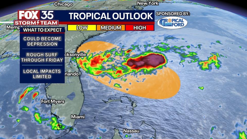
ORLANDO, Fla. - A tropical disturbance a little over 100 miles away from the Florida east coast will be bringing torrential tropical downpours to Central Florida. This system is just shy of becoming a tropical depression, regardless if it is or not the impacts will remain the same for us.
This rain will impact the morning commute, and could lead to ponding on roadways plus reduced visibility under the heavy downpours. With plenty of moisture at play, these showers will be dumping a lot of rain over a short span of time.
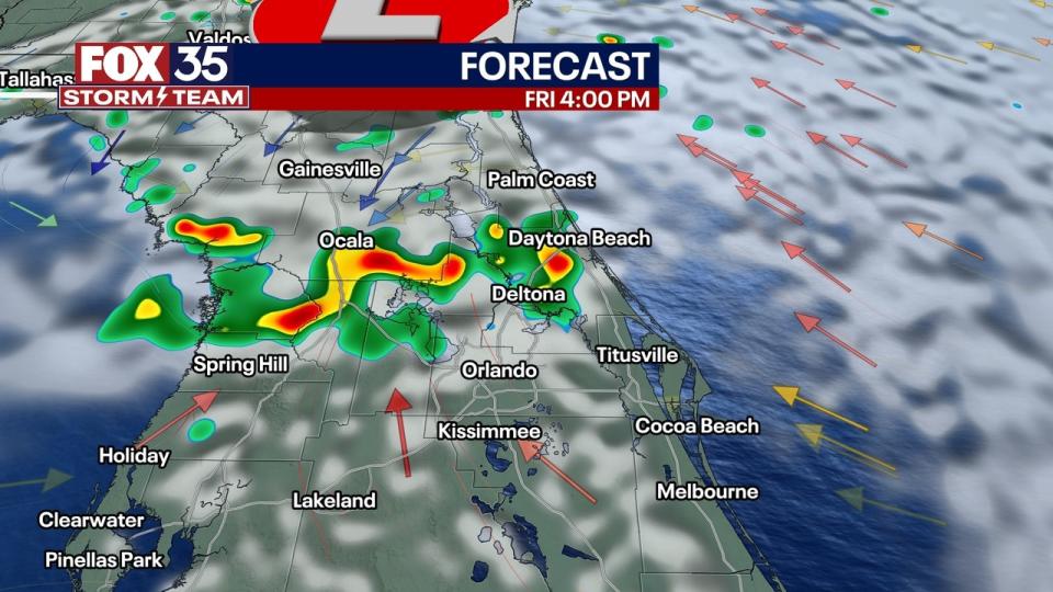
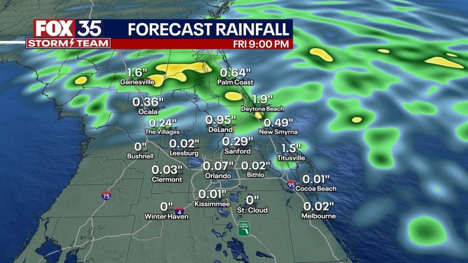
Areas south of the Orlando Metro won't see as much rain as those areas north of the city, where some isolated areas may see rainfall totals that could approach 3-6 inches. This afternoon, coupled with the peak heating of the day, these showers will grow heavier and more widespread before wrapping up overnight.
Dangerous and rough surf conditions are expected at the beaches today as well. Breaking wave heights will be around 5-8 feet with a high risk of rip currents. Some areas may experience beach erosion as well.
LOOKING AHEAD: Into the weekend and beyond, the big story will be the shift in winds leading to hot temperatures and more rain chances. Scattered showers and storms are on the way this weekend and continue into next week as well. Temperatures will be hot, with highs back in the low and mid 90s.
As a tropical disturbance approaches Florida, waves of rain will begin moving onshore overnight.
The best chances will be from the Cape and to the north. Expect showers to continue into Friday morning with occasional heavy downpours. Winds will actually become lighter for Central Florida as the system heads to the NW towards the Florida and Georgia coastline.
FRIDAY: As the tropical low moves onshore sometime early Friday, rain will continue across northern counties. Scattered showers and storms will be possible through the afternoon. Areas farther south (south of I-4) will actually be mostly dry and warm, with highs into the low 90s. Rough coastal conditions will continue with high surf and a high rip current risk on Friday.
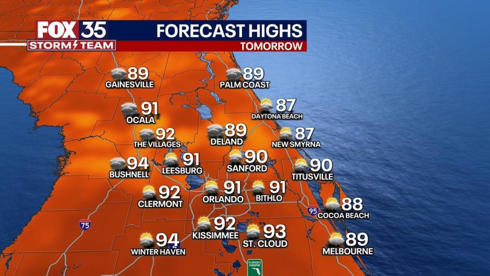
LOOKING AHEAD: Into the weekend and beyond, the big story will be the shift in winds leading to hot temperatures and more rain chances. Scattered showers and storms will be possible this weekend before growing more widespread next week. Temperatures will be hot, with highs back in the low and mid-90s.
TROPICS: Tropical Storm Alberto made landfall this morning near Tampico, Mexico, around 8 a.m. It has weakened and is now post-tropical. We're closely monitoring two other areas of potential tropical development. One is over the same area, the Bay of Campeche, where Alberto previously formed. It has a medium, 60% chance of development over the next seven days.
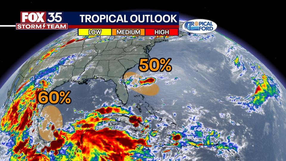
A second potential development area is also being monitored, which is off the east coast of Florida and Georgia, with a 50% chance. While this is a very disorganized system, there is the chance that a tropical depression may try to form late tonight or Friday morning as it inches closer to the Florida and Georgia coastline. These impacts would be concentrated in areas near the Jacksonville and Florida/Georgia state line.
Heavy downpours, gusty winds, and rough surf are expected for northern Florida. In Central Florida, most of our impacts will be limited to our northernmost counties, except for rough surf conditions along the beaches. It's important to remember that several factors could try to limit development, so stay tuned for more updates as they become available.

