'Potentially catastrophic' Hurricane Beryl made landfall. Will it impact Texas?
Note: This file is no longer being updated. For the latest information, visit the Wednesday file.
Hurricane Beryl made landfall on Grenada's Carriacou Island mid-morning Monday as a Category 4 with 150 mph winds.
The hurricane is expected to remain an "extremely dangerous major hurricane" as its core slams through the eastern Caribbean, National Weather Service forecaster Eric Blake said.
Beryl weaken some as it moves through the central Caribbean midweek, but is forecast to remain a hurricane when it makes landfall, again, on Mexico's Yucatan Peninsula later this week.
"Potentially catastrophic wind damage is expected where the core of Beryl moves through portions of the Windward Islands," Blake warned in the advisory.
The system reached tropical storm status Friday before strengthening into a hurricane Sunday. Hurricane Beryl reached Category 4 status with winds of 130 mph as record-warm ocean temperatures led to rapid intensification before dropping down to a Category 3 early Monday morning and returning to a Category 4 later again, USA TODAY reported.
The storm is the earliest on record to reach Category 4 status and is the first major hurricane east of the Lesser Antilles to hit in June.
More: Hurricane Beryl moving across Caribbean. Could it impact Texas over Fourth of July?
More: US sees more than 1,200 tornadoes so far in 2024. Here's how many have hit Texas
Will Hurricane Beryl hit Texas?
Even after initial landfall on the Windward Islands, Beryl is expected to remain an "extremely dangerous major hurricane" until it reaches Mexico, National Weather Service forecaster Eric Blake said in an advisory early Monday.
"Potentially catastrophic wind damage is expected where the core of Beryl moves through portions of the Windward Islands," Blake warned.
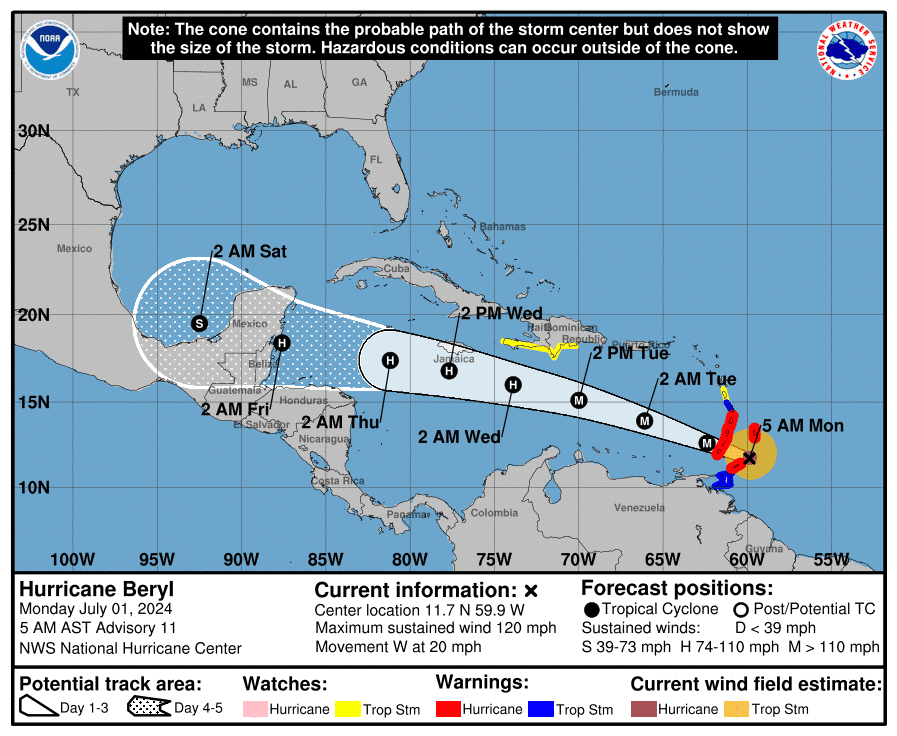
It is unlikely that the U.S. will undergo any significant impact from Beryl, as the storm is expected to hit farther south. However, AccuWeather Lead Hurricane Forecaster Alex DaSilva warns that there are potential circumstances in which the storm could track northward instead.
"The most likely scenario is for the storm to move westward into Mexico," DaSilva said. "However, it is very important to note that if the high pressure across the Southeast weakens, that can allow the storm to move farther north and potentially directly impact the Gulf Coast."
What is rapid intensification?
Rapid intensification is the phenomenon of a storm strengthening by at least 35 mph in a 24-hour period. Fueled by record-warm ocean temperatures, Beryl gained 95 mph within a 42.5-hour span.
It's also likely that a huge Saharan dust plume has also contributed to the storm's intensity as the dry air pocket carries heavy moisture, one of the most prominent ingredients needed for tropical cyclone development.
More: Why are skies across Texas hazy this week? Huge Saharan dust plume, experts say
Hurricane storm tracker: See active storms in the Atlantic
Weather watches and warnings issued in Texas
How many hurricanes have occurred this season?
Beryl is the first hurricane of the season, although it comes less than two weeks after Tropical Storm Alberto made landfall along Texas' coastal region off the Gulf of Mexico.
The first named storm in the 2024 Atlantic hurricane season, Alberto sustained winds near 45 mph, although no significant flooding occurred.
Interactive map: Hurricanes, tropical storms that have passed near your city
This article originally appeared on Lubbock Avalanche-Journal: Will 'potentially catastrophic' Hurricane Beryl impact Texas?

