Record-breaking rain: Here's how much rain fell across the Lansing area
LANSING — At least one record was broken in the torrential rains that the remnants of Hurricane Beryl, which struck the Gulf Coast earlier in the week, brought across Michigan Tuesday and Wednesday.
The storm dumped rain in a wide swath from the southwest corner of the state through the Thumb before moving into Canada.
Several mid-Michigan communities reported high rainfall totals, with East Lansing seeing the heaviest by a wide margin.
East Lansing saw 7 inches of rain, the National Weather Service said, and city officials are still assessing damage from flooding that swamped cars and damaged a local bookstore.
On Wednesday a record was broken in the Lansing area, according to the National Weather Service. At a location near the Capital Region International Airport 2.1 inches of rain fell, breaking a record for July 10 of 1.41 inches set in 2020.
Here's how much rain fell Tuesday and Wednesday around the region:
Grand Ledge: About 2 inches
Lansing: About 3 inches
DeWitt: Just over 2 inches
Mason: 3½ inches
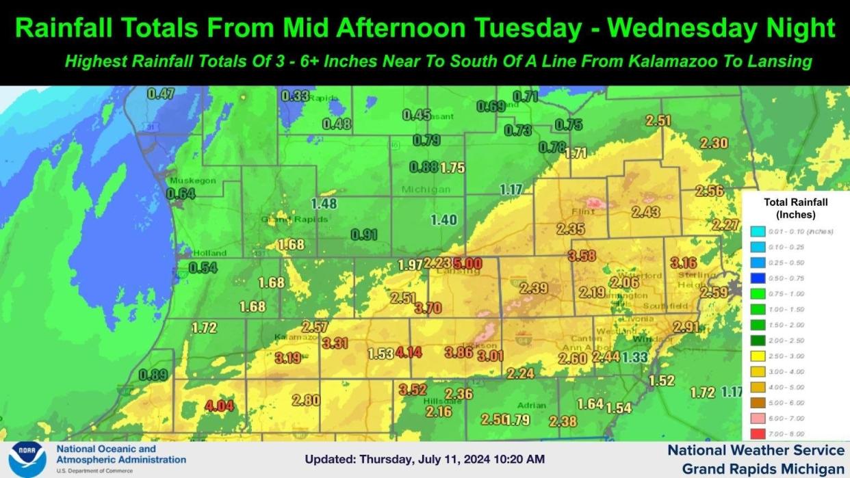
The National Weather Service also released a map showing rainfall totals from mid-afternoon Tuesday through Wednesday, during the heaviest rain, and said the totals varied from 3-6 inches near to south of a line from Kalamazoo to Lansing.
Rainfall totals in that time span include:
Eaton Rapids area: 3.7 inches
St. Johns area: 1.4 inches
North Lansing area: 5 inches
Howell/Fowlerville area: 2.39 inches
Charlotte area: 2.51 inches
Ionia area: 0.91 inches
This article originally appeared on Lansing State Journal: Record-breaking rain: Here's how much rain fell across the Lansing area

