Saharan dust shields hurricane development, but watch out for Florida heat Saturday
While the National Hurricane Center continued its confidence that there would be no tropical activity in Atlantic areas for the next week, Saharan dust and a few tropical waves were what forecasters watched Saturday.
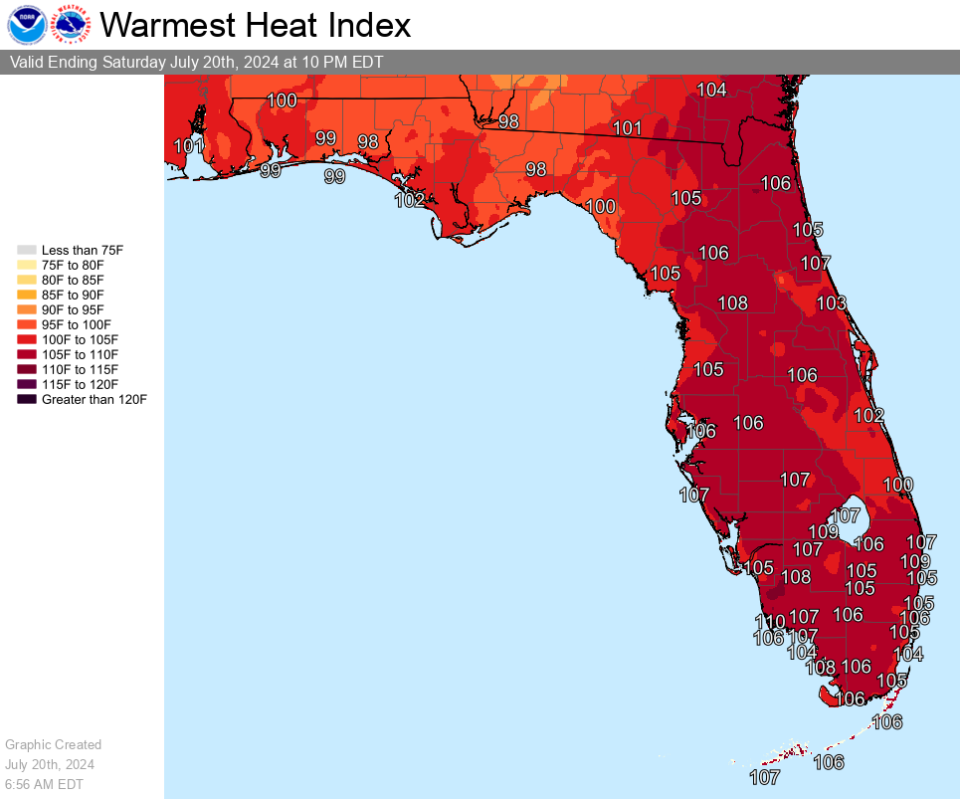
The real impact for Florida on Saturday will come from the heat. The entire Florida peninsula can expect triple-digit heat indexes with some in Southwest Florida predicted for 110 degrees, and 106 as far north as Jacksonville. Heat advisories are in effect for seven South Florida counties.
A wave of Saharan dust is expected to arrive in South Florida Saturday morning and move north, arriving around Cape Canaveral by Sunday. The dust is expected to be thickest in South Florida, dissipating as it moves north.
Tropical moisture may increase Florida's rain chances starting Monday, but, according to Ryan Truchelut, chief meteorologist at WeatherTiger, it won’t be anything organized. Saharan dust, high wind shear and other factors are expected to keep the tropics quiet for the days ahead.
The Hurricane Center is monitoring three tropical waves.
The peak of hurricane season runs from mid-August through mid-October. If your hurricane supplies are running low, or you haven't started an emergency kit, Florida's next sales tax holiday the end of August can help you save money.
Possible impact of tropical wave on Florida
A tropical wave is expected to approach the Florida peninsula Sunday, bringing downpours and gusty thunderstorms. A couple of waterspouts could occur, according to AccuWeather.
"As the tropical wave approaches and moves northwestward across the state from Sunday to Tuesday, an uptick in the showers and thunderstorms will occur with the potential for some to bring flooding downpours, strong wind gusts and even waterspouts near the beaches," AccuWeather Lead Hurricane Expert Alex DaSilva said.
The tropical wave is not forecast to develop into a tropical depression or a named tropical storm.
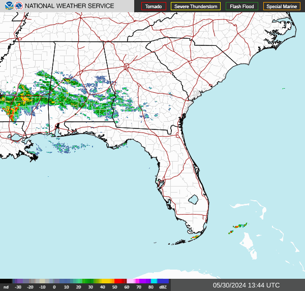
Florida weather radar: Track storms as they move across state
Saharan dust map: How long will tropics remain quiet?
The Saharan dust and winds are keeping the tropics quiet now, but forecasters say that will likely change.
"The favorable conditions that yielded Beryl are likely to return at some point in August, and that will probably yield an extended burst of hurricane activity," said Dr. Ryan Truchelut, chief meteorologist at WeatherTiger.
"WeatherTiger’s real-time forecast remains for around twice the amount of storm activity in a normal hurricane season."
The next storm of the season will be Debby.
Extreme heat continues across Florida. See weather watches, warnings
Portions of Southeast, South, Southwest Florida: Head index of 105-110 expected today.
Counties under a heat advisory include:
Glades
Hendry
Palm Beach County
Collier County
Broward County
Miami-Dade County
Monroe
What is NOAA tracking in Atlantic basin?
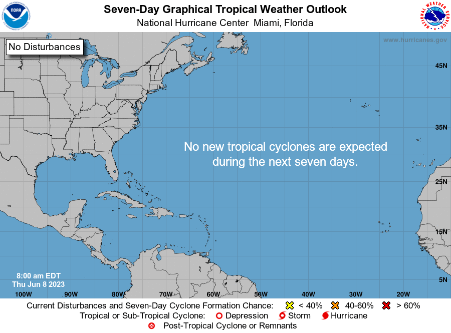
The National Hurricane Center said no tropical cyclone activity is expected over the next several days.
Elsewhere in the tropics, the National Hurricane Center is monitoring three tropical waves. Here's the latest update from the NHC as of 8 a.m. July 20:
Tropical wave 1: An eastern Atlantic wave was identified via satellite imagery. It's producing some showers.
Tropical wave 2: In the central Caribbean, this wave is expected to move from the Windward Passage to northern Colombia and helping to induce scattered to numerous showers with embedded thunderstorms over Hispaniola and regional waters as well as across the Windward Passage and the waters between eastern Cuba and Jamaica. These storms may produce heavy downpours, lightning and gusty winds.
Tropical wave 3: Another tropical wave over the Yucatan Peninsula and Guatemala is moving westward and producing scattered showers and may produce gusty winds or stronger storms in parts of the region.
Who is likely to be impacted?
A tropical wave is expected to bring tropical moisture to Florida starting Sunday.
Forecasters urge all residents to continue monitoring the tropics and to always be prepared. That advice is particularly important for what is expected to be a very active hurricane season.
When is next Florida hurricane tax-free supplies holiday?

Save on hurricane supplies between Aug. 24 and Sept. 6. This will be the final tax-free holiday for 2024 when it comes to emergency supplies and it comes during the busiest period of the hurricane season.
Can't afford a generator or weeks of food? Here are the basics you should have on hand.
Eligible items included in the tax-free holiday include:
A portable generator used to provide light or communications or preserve food in the event of a power outage with a sales price of $3,000 or less.
A tarp or other flexible waterproof sheeting with a sales price of $100 or less.
An item normally sold as, or generally advertised as, a ground anchor system or tie-down kit with a sales price of $100 or less.
A smoke detector or smoke alarm with a sales price of $70 or less.
A fire extinguisher with a sales price of $70 or less.
A carbon monoxide detector with a sales price of $70 or less.
A nonelectric food storage cooler with a sales price of $60 or less.
A portable power bank with a sales price of $60 or less.
A gas or diesel fuel tank with a sales price of $50 or less.
A portable self-powered radio, two-way radio, or weather-band radio with a sales price of $50 or less.
A package of AA-cell, AAA-cell, C-cell, D-cell, 6-volt, or 9-volt batteries, excluding automobile and boat batteries, with a sales price of $50 or less.
A portable self-powered light source (powered by battery, solar, hand-crank, or gas) with a sales price of $40 or less, including: flashlights, lanterns and candles.
Eligible light sources and radios qualify for the exemption, even if electrical cords are included in the purchase.
Reusable ice (ice packs) with a sales price of $20 or less.
➤ See full list of items, including pet and cleaning supplies, exempt from sales tax
When is the Atlantic hurricane season?
The Atlantic hurricane season runs from June 1 through Nov. 30.
When is the peak of hurricane season?
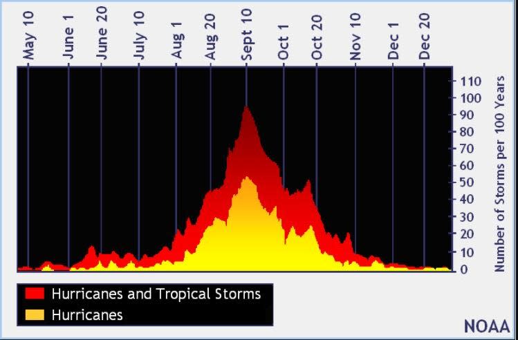
The peak of the season is Sept. 10, with the most activity happening between mid-August and mid-October, according to the Hurricane Center.
National Hurricane Center map: What are forecasters watching now?
Systems currently being monitored by the National Hurricane Center include:
Interactive map: Hurricanes, tropical storms that have passed near your city
Excessive rainfall forecast
What's next?
We will continue to update our tropical weather coverage daily. Download your local site's app to ensure you're always connected to the news. And look for our special subscription offers here.
This article originally appeared on The Daytona Beach News-Journal: NHC forecasts no storms, but heat is Florida weather to watch

