An excessive heat warning kicks off the week in KC. Which days will be the hottest?
A combination of excessive heat and humidity will send temperatures to dangerous levels for multiple days this week in Kansas City, according to the National Weather Service in Kansas City.
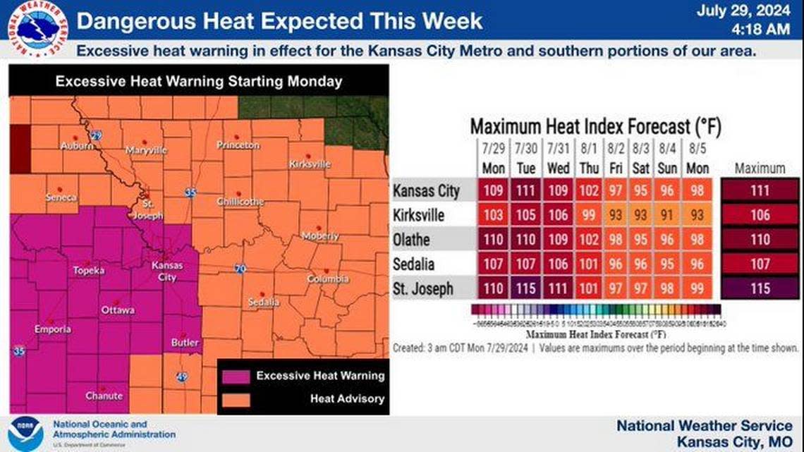
The scorching temperatures have prompted the weather service to issue an excessive heat warning for the Kansas City metro and areas to the south and west that goes into effect from 1 p.m. Monday until 7 p.m. Thursday. Meanwhile, a heat advisory has been issued for locations north of Kansas City.
Temperatures are expected to climb to and above 100 degrees this week, the first 100-degree days of the year.
Heat index values of up to 115 degrees are forecast for Monday through Wednesday afternoon. Tuesday and Wednesday are expected to be the hottest days, the weather service said.
Overnight temperatures will range from 75 to 80 degrees, providing little relief from the heat. Temperatures above 80 degrees do not allow people to recover from daytime heat.
High temperatures and humidity can be hazardous, especially for vulnerable populations such as older persons, young children and those with health conditions. People are advised to stay hydrated, limit outdoor activities during the hottest parts of the day, and check on neighbors who may be at risk.
Heat-related illnesses increase significantly during periods of extreme heat and high humidity.
Showers, thunderstorms also in KC forecast
While the excessive heat is the primary concern, there is a chance for rain in the Kansas City area.
“Scattered afternoon and evening thunderstorms are possible today through Thursday,” the weather service said. “A couple storms may produce gusty winds.”
Small hail may occur with the strongest storms, the weather service said.
Any storms are expected to develop between 1 and 6 p.m. Monday along Interstate 70 in eastern Kansas and then push east toward the metro area, which could limit some of the heat.
The weather looks drier on Tuesday. Storms and thunderstorms will be possible on Wednesday night. The weather service said these storms could break the heat for the week.
Dangerous heat will still be possible south of the Missouri River on Thursday.
Above-normal temperatures and near-normal precipitation are possible for the first week of August.

