Shower chances continue Thursday, pattern becoming more unsettled

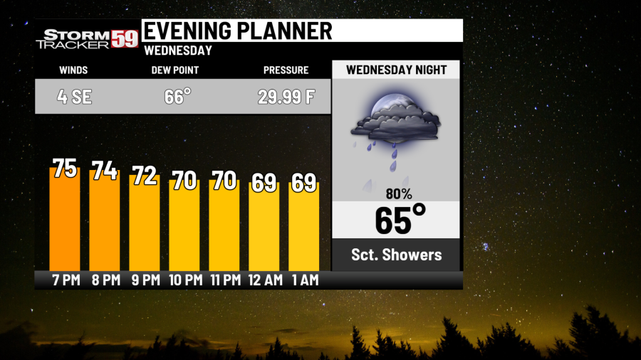
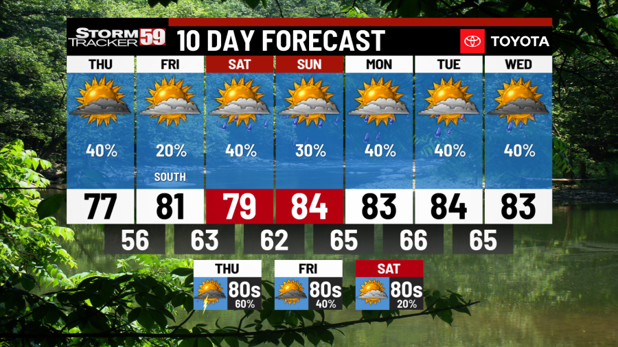
Tonight features scattered showers with a few rumbles of thunder – some of these storms could produce locally heavy rain. Any rain is appreciated in our region and most of us will get in on the action tonight into Thursday. It’s a muggy night on the way with lows dropping into the mid 60s. We haven’t had a lot of rain recently – be careful on the roads as the rain will lift embedded material from the pavement and could create a few slick spots.
Thursday keeps the risk for a few scattered showers around with our cold front down across the New River Valley in Virginia in the morning and an area of low pressure moving along that front in that vicinity. This will keep the clouds and a few showers around in the morning with afternoon clearing. By the afternoon, the weather will be fantastic in our northern counties, with clearing skies and temperatures in the mid 70s – it’s been a little while since we’ve had below average temperatures! Temperatures Thursday night will dip back into the mid 50s in what will be a very comfortable night as high pressure noses in.
Friday provides plenty of sunshine with high pressure up to our north across the Great Lakes being the dominant weather pattern feature in our neck of the woods. Wednesday’s cold front will still be across the Carolinas and an isolated shower can’t be ruled out in our southern counties in the afternoon – however, most of us will be dry with comfortable temperatures with highs in the low 80s.
Saturday sees Wednesday’s cold front lift back up to the north toward our area. With the stalled front scooting pretty close to our region, expect scattered and storms to be a good bet by the afternoon, some of which could produce heavy rainfall once again. Highs will be near 80.
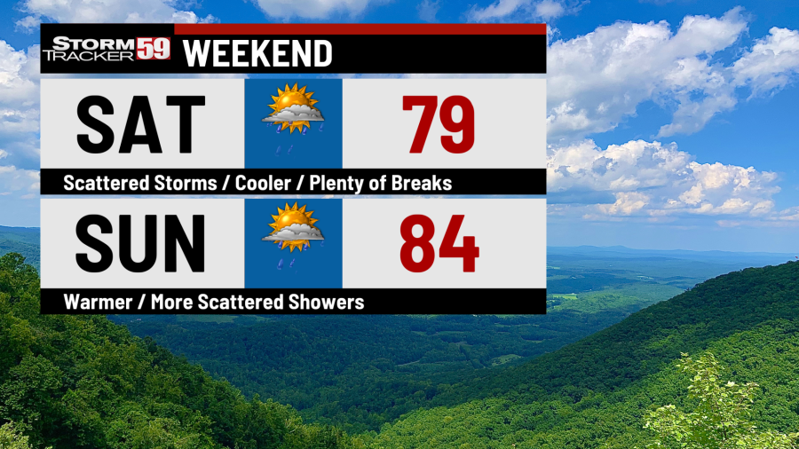
Sunday provides isolated to widely scattered storms as our stalled front scoots back down to the south. Highs temperatures will be in the low to mid 80s.
Summer lawn maintenance to keep your grass healthy in hot weather
Monday continues the see-saw pattern of stationary front nudging, as this front looks to lift back to the north to the Virginia/North Carolina border. This will be close enough to give us the risk for more scattered showers and storms. Highs will once again be in the low to mid 80s.
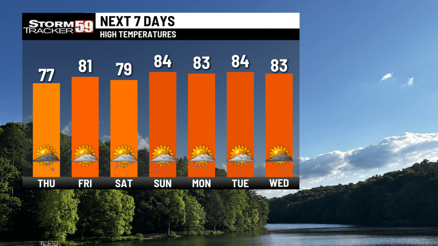
Tuesday keeps the risk for scattered showers and storms around with a muggy air mass and a stalled frontal boundary remaining nearby with highs in the mid 80s.
Heat index warnings can save lives on dangerously hot days − if people understand what they mean
Wednesday continues our unsettled pattern with scattered storms likely by the afternoon and high temperatures in the mid 80s.
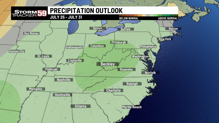
Looking ahead in your extended forecast, it’s an unsettled pattern that will continue to provide opportunities for beneficial rains as a couple of waves of low pressure ride along the aforementioned stalled frontal boundary. The proximity of this front to our region will be key in determining rainfall chances – we’ll likely see rain around on Thursday with highs in the low 80s. Trends have our front settling a little farther south Friday into Saturday with only isolated rain chances and highs in the mid 80s.
TONIGHT
Scattered showers and storms. Lows in the mid 60s.
THURSDAY
Scattered showers, especially south. Some afternoon clearing. Cooler. Highs in the mid 70s.
FRIDAY
Partly sunny, isolated PM storm. Highs near 80.
SATURDAY
Scattered storms. Plenty of breaks. Highs near 80.
SUNDAY
Isolated storms, otherwise partly sunny. Highs in the mid 80s.
MONDAY
Scattered storms. Highs in the mid 80s.
TUESDAY
Scattered storms. Highs in the mid 80s.
WEDNESDAY
Scattered storms. Highs in the mid 80s.
THURSDAY
Scattered storms. Highs in the low 80s.
FRIDAY
Isolated storms. Highs in the mid 80s.
SATURDAY
Isolated storms. Highs in the mid 80s.
Copyright 2024 Nexstar Media, Inc. All rights reserved. This material may not be published, broadcast, rewritten, or redistributed.
For the latest news, weather, sports, and streaming video, head to WVNS.

