'Significant relief' from heat in Cape Cod weather forecast. When will it cool down?
The melty marathon of sweltering Cape Cod weather looks to be running out of steam. According to the National Weather Service, a cold front is on the way from the Midwest which will result in "significant relief from the heat and humidity."
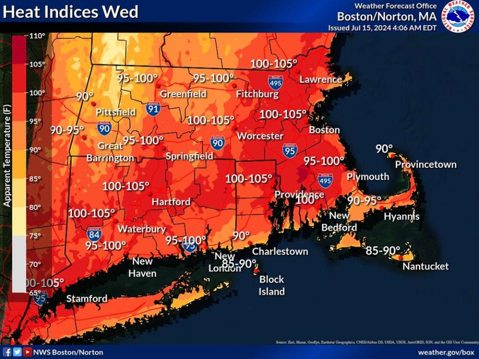
But the terrarium-like weather will stick around through Wednesday, when heat indices will be in the 90 to 95 degree range on the Cape. According to the National Weather Service, the heat index "is what the temperature feels like to the human body when relative humidity is combined with the air temperature."
Much of southern New England, excluding Cape Cod, is under a Heat Advisory through Wednesday evening, said Candice Hrencecin, a meteorologist at the National Weather Service Boston/Norton office. Heat index values up to 103 are expected for parts of Connecticut, Rhode Island and southeastern Massachusetts.
Cape Cod weather relief on the way
Then, according to the National Weather Service forecast discussion, "a cold frontal passage late Wednesday into Thursday will give way to a much more comfortable airmass to end this work week." Hrencecin said that humidity levels will drop significantly during this time frame.
While Thursday and Friday daytime temperatures will nudge 80 degrees on Cape Cod, nighttime low temperatures will be around 65 on Thursday and around 60 on Friday.
Heading into the weekend, we are likely to see seasonably average temperatures on the Cape, a more comfortable weather setup than the recent muggy hot spell.
Here is the Hyannis forecast from the National Weather Service:
Tuesday: Mostly sunny, with a high near 88. Southwest wind 10 to 16 mph, with gusts as high as 28 mph.
Tuesday night: A slight chance of showers and thunderstorms before 9 p.m. Partly cloudy, with a low around 74. Southwest wind 8 to 17 mph. Chance of precipitation is 20%.
Wednesday: Mostly sunny, with a high near 87. Southwest wind 11 to 14 mph, with gusts as high as 26 mph.
Wednesday night: A chance of showers and thunderstorms, then showers likely and possibly a thunderstorm after 1 a.m. Mostly cloudy, with a low around 72. Southwest wind 7 to 10 mph, with gusts as high as 20 mph. Chance of precipitation is 60%.
Thursday: A chance of showers. Partly sunny, with a high near 82. West wind 6 to 9 mph. Chance of precipitation is 50%.
Thursday night: Partly cloudy, with a low around 65. Southwest wind around 6 mph becoming north after midnight.
Friday: Mostly sunny, with a high near 80. North wind around 7 mph.
Friday night: Mostly clear, with a low around 61. South wind around 5 mph becoming light and variable in the evening.
Saturday: Mostly sunny, with a high near 83. Southwest wind 3 to 8 mph.
Saturday night: Partly cloudy, with a low around 70. Southwest wind around 7 mph.
Sunday: Mostly sunny, with a high near 83. West wind 5 to 8 mph.
Eric Williams, when not solving Curious Cape Cod mysteries, writes about a variety of ways to enjoy the Cape, the weather, wildlife and other subjects. Contact him at ewilliams@capecodonline.com. Follow him on X: @capecast.
The Cape Cod Times is providing this coverage for free as a public service. Please take a moment to support local journalism by subscribing.
This article originally appeared on Cape Cod Times: Cape Cod weather forecast: Hot, humid weather will end this week

