How soon could Sioux Falls see the end of the wet weather?
Sioux Falls and the surrounding area have been experiencing heavier rainfall than usual this summer.
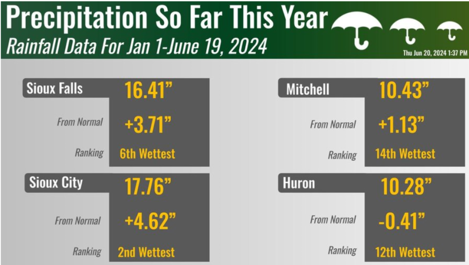
According to a post from the National Weather Service in Sioux Falls on X, formerly Twitter, the last time southeastern South Dakota experienced such rainfall was halfway through June 2012. Precipitation totals from Jan. 1 to June 19 in Sioux Falls, Sioux City, Mitchell and Huron are all in the top 15 historic totals so far this year.
“We’re in a wet spell right now,” said Tim Masters, a hydro-meteorological technician with NWS in Sioux Falls. “And it's well above normal.”
In the first 19 days of June, Sioux Falls accumulated 4.09 inches of rainfall, near its monthly average of 4.23 inches. Another round of storm systems is predicted for Friday, increasing the risk of flooding in Sioux Falls.
However, looking at the Climate Prediction Center’s long-range forecast, Masters says this wet spell might not last much longer.
More: Live updates: LCSO reports flooding over roads. Sioux Falls under flood watch until Saturday.
“I'm kind of getting a feeling that we might be toward the end,” he said. “We might have a little bit more wet weather toward the end of June, but then things are trending toward drier for the rest of the summer.”
After storms this weekend, the weather forecast is mostly clear and sunny through Wednesday.
Kathryn Kovalenko is an intern for the Argus Leader, paid for by a grant program through Bethel University this summer.
This article originally appeared on Sioux Falls Argus Leader: Sioux Falls might be reaching the end of wet spell, NWS official says
