Southeast SD flooding claims at least one life as focus shifts to Dakota Dunes
- Oops!Something went wrong.Please try again later.
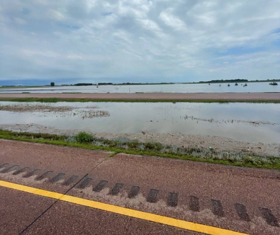
A flood-affected segment of Interstate 29 on June 21, 2024. (Courtesy of South Dakota Department of Transportation)
Federal, state and local officials are focusing their efforts on a voluntary evacuation of Dakota Dunes and a levee construction project across Interstate 29 near McCook Lake as they continue responding to historic rainfall and flooding in southeast South Dakota that has claimed at least one life.
Gov. Kristi Noem led a press conference Sunday in North Sioux City. She shared news of the death but declined to provide any information about the person, circumstances or location, other than saying the death was related to flooding.
“Because of respect for the family, I’m not going to share any details around that,” Noem said. “All I’m going to say is that I want to remind everybody to remember the power of water and the flow of water, and to stay away from flooded areas.”
Sunday morning, prior to Noem’s press conference, the state Department of Public Safety issued a news release saying that an 87-year-old man died Saturday afternoon in a single vehicle crash 5 miles northeast of Harrisburg.
The man was driving a utility terrain vehicle on a road that was closed because one of the shoulders had washed away. The department said the driver attempted to turn around and went backward over the washout, was ejected from the UTV and was pronounced dead at the scene. The man’s name has not been released, pending notification of family members.
Asked after the Sunday press conference whether the 87-year-old man’s death was the one Noem was referencing, her spokesman Ian Fury said, “I’ll let Highway Patrol report that situation as they normally do.” Department of Public Safety spokesman Brad Reiners said, “We are not releasing additional information at this time.”
Ten to 15 inches of rain fell from Thursday to Saturday in the hardest-hit area of southeast South Dakota, northwest Iowa and southwest Minnesota, with totals exceeding 17 inches in some locations. During the rain and the immediate aftermath, many basements and roads flooded, and local emergency responders conducted numerous rescues.

Sioux Falls temporarily asked residents to limit showers, clothes washing, dishwasher use and other contributions to the city’s overstressed wastewater system. The city rescinded that request Sunday, saying the system was “trending in the right direction.”
Attention has since shifted to rising rivers and creeks. The Big Sioux River at Sioux City surpassed 43 feet Sunday on its way to an expected crest Sunday night, surpassing the former record of 37.7 feet for that segment.
The Big Sioux and other swollen rivers and streams flow into the Missouri River in the southeast corner of the state, as do other rivers such as the Niobrara in Nebraska, placing North Sioux City and Dakota Dunes in the crosshairs of the collected floodwaters.
John Remus is the chief of the Army Corps of Engineers’ Missouri River Basin Water Management Division. He said the corps lowered releases from Fort Randall and Gavins Point dams — upstream of North Sioux City and Dakota Dunes — to ease downstream flooding. There is plenty of capacity behind Fort Randall, he said, but the water behind Gavins Point was near the top of the floodgates Sunday afternoon and still rising.
“That’s why we have not been able to cut outflows as much as we originally wanted to,” Remus said. “We’re going to continue to monitor that. It appears that the inflows are starting to peak and turn over. As soon as we can, we’ll start decreasing the flows.”
The high flows headed for Dakota Dunes led authorities to issue a voluntary evacuation order.
Jason Westcott, emergency management director for Union County, said local crews are working to strengthen dikes in the area and have opened a self-serve sandbag station for local residents at the county highway shop in Elk Point.
But he stressed that people should evacuate if they’re in harm’s way.
“The county currently is about maxed out on being able to do water rescues at this point,” Westcott said. “As we move further into this incident and it becomes more serious in this area, we may not have the ability to rescue people from their homes if they continue to stay there.”
The county currently is about maxed out on being able to do water rescues at this point. As we move further into this incident and it becomes more serious in this area, we may not have the ability to rescue people from their homes if they continue to stay there.
– Jason Westcott, Union County emergency management director
Craig Smith, director of operations for the state Department of Transportation, said Interstate 29 would close at 6 p.m. Sunday between exits 2 and 9.
The closure will allow work crews to build a levee across Interstate 90 at Exit 4, just north of North Sioux City and Dakota Dunes, and tie it in with other protective structures. That section of interstate is sandwiched between the Big Sioux River to the east and McCook Lake to the west.
Smith said 1 to 2 feet of water could flow over the interstate there as floodwaters crest, and the closure will remain in effect as long as the levee is needed.
A lengthy detour will route drivers west through Vermillion, via Highway 50 in South Dakota and I-29 Exit 144 in Iowa.

Some other roads in the southeast region of the state remain closed due to flooding. Drivers are encouraged to visit sd511.org or download the SD511 mobile app to view all current road closures, no-travel advisories and highway obstructions.
Noem signed an emergency declaration Saturday, which allows the state to begin paperwork for potential help from the Federal Emergency Management Agency. She urged everyone affected by the flood to document their damages and contact their insurance agent and local emergency manager, so that the information can be used in the state’s application to FEMA.
Sunday’s weather was dry and hot in southeast South Dakota. The National Weather Service forecast includes chances for isolated storms Monday and Tuesday, and sunny weather on Wednesday.
“We’re hoping that by Thursday morning we’re in a very different situation and water starts to recede,” Noem said.
EDITOR’S NOTE: This story has been updated since its initial publication with additional flooding information and reaction from state officials.
No-boating declaration issued
To protect public health, safety and private property during ongoing flooding, Gov. Kristi Noem on Saturday enacted a no-boating declaration for the following waters:
Lake Alvin in Lincoln County.
Lake Henry in Bon Homme County.
Marindahl Lake in Yankton County.
Menno Lake in Hutchinson County.
Swan Lake in Turner County.
Wall Lake in Minnehaha County.
Lake Vermillion in McCook County.
Noem’s declaration states, “This restriction shall be in full force and effect from this date forward until modified or removed by a subsequent declaration by the Office of the Governor, or by Kevin Robling, Secretary of the Department of Game, Fish and Parks, who I am hereby appointing as my designee in order to enable him to add to, delete or modify boating restrictions for any bodies of water similarly affected in South Dakota.”
GET THE MORNING HEADLINES DELIVERED TO YOUR INBOX SUPPORT NEWS YOU TRUST.
The post Southeast SD flooding claims at least one life as focus shifts to Dakota Dunes appeared first on South Dakota Searchlight.

