Southwest Gulf on alert for new tropical development
June 23 (UPI) -- As a new disturbance continues to roll across the southwestern Gulf of Mexico into Sunday night, conditions will be favorable to spawn a tropical depression or storm just days after Alberto formed in the same region, AccuWeather meteorologists say. The system will spread heavy rain into northeastern Mexico while downpours douse parts of South Texas.
"This feature in the southwestern Gulf that we are monitoring is a disturbance on the Central America gyre that has broken away and rolled west-northwestward this weekend," AccuWeather Lead Tropical Meteorologist Alex DaSilva said.
A gyre is a large, slowly spinning low-pressure area that often enhances showers and thunderstorms in its circle of influence. A gyre over Central America and southern Mexico is common this time of the year and can contribute to tropical storm or hurricane formation over the Caribbean Sea, Gulf of Mexico and the eastern Pacific Ocean.
AccuWeather began monitoring the system's potential in early June and issued an official track map for the center of the rainstorm late last week. The system will push heavy rain inland with the risk of flooding, regardless of its official classification.
AccuWeather refers to it as a tropical rainstorm to raise awareness of the potential dangers. Only the National Hurricane Center can officially designate the system as a tropical depression or tropical storm.
The system has a chance of becoming a tropical depression or storm prior to moving onshore in northeastern Mexico later Sunday night. The southwestern Gulf system may become the second such system of the 2024 Atlantic hurricane season. The next two names on the list for 2024 are Beryl and Chris.
This new storm's focus will be on northeastern Mexico and along the immediate lower Rio Grande Valley on the Texas side of the border.
DaSilva explained that impacts along the central and northern Texas coast from this system will be significantly less than Alberto's as this new system is somewhat more compact and may track a bit farther to the south in Mexico.
Alberto's broad circulation brought significant storm surge flooding as far to the north as the upper Texas coast.
However, even a lower-grade storm surge along the Texas coast can lead to flooding problems, especially since some protective buffers may have been compromised and access roads may require repair in the wake of Alberto.
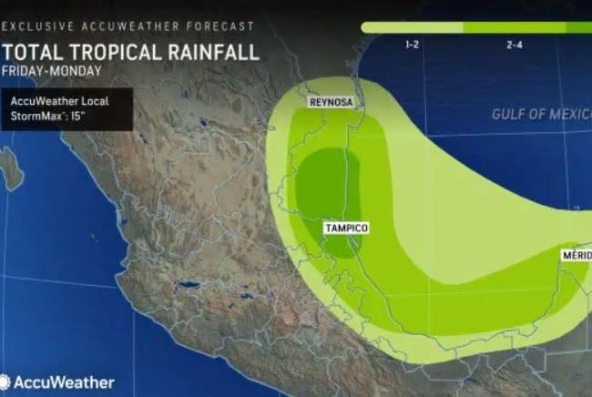
Widespread rainfall of 4-8 inches is anticipated in northeastern Mexico with some areas along the coast and inland on the east-facing slopes of the mountains picking up 8-12 inches. Localized amounts may be even higher. Since some of these areas were hit with similar rainfall from Alberto just a few days earlier, the flash flood and mudslide risk is significantly higher.
Portions of the lower Rio Grande Valley of Texas may experience flash flooding as well as another dose of beneficial rain, due to long-term drought conditions.
Beach and boating interests should be prepared for rapidly deteriorating conditions on Sunday. As the center moves over open waters of the southwestern Gulf, after crossing Mexico's Yucatan Peninsula, development may be swift as winds and waves increase.
The beginning of a super-charged hurricane season
In the wake of the system along the northeast Mexico coast, the Atlantic may become quiet once again and remain so for many days. A lull in tropical activity is not uncommon during July.
"We will be on the lookout for another weak system that could try to develop in the southwestern Gulf of Mexico around the start of July," DaSilva said, "But, just like the system from Saturday to Sunday, it will not have much time to develop before being pushed into northeastern Mexico."
After the flurry of tropical activity dies down and the mid-summer lull occurs, AccuWeather meteorologists forecast that the Atlantic will become a hotbed later in the summer and into the fall with a bumper crop of tropical storms and hurricanes.
A significant number of tropical systems may experience rapid strengthening. Where this occurs near land, it could significantly raise the risk to lives and property.

