Strong wind, rotation risk as Sunday storms push into Maritimes
A risk for severe thunderstorms will brew across portions of eastern Quebec and the Maritimes Sundy as a low-pressure system traversing the country makes its final stop over the region.
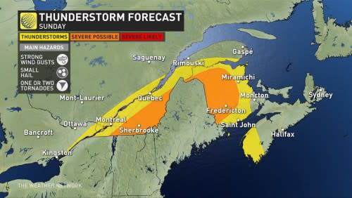
Scattered thunderstorms expected to develop Sunday afternoon could bring a risk for strong wind gusts to Quebec’s Eastern Townships and New Brunswick. One or two tornadoes can’t be ruled out.
Monitor the radar through the day Sunday and have a plan in place in case watches and warnings are issued for your area.
DON’T MISS: Your Canada Day weekend forecast holds a mix of gloom and fantastic days
Sunday storms develop as system arrives
A low-pressure system that’s brought plenty of rough weather across the country will sweep into Quebec and the Maritimes on Sunday.
We’ll start the day with heavy rain across New Brunswick, serving as a prelude for the rougher weather to come later in the day.

Scattered thunderstorms are expected to develop early Sunday afternoon across Quebec, mainly south of the St. Lawrence River. These storms could turn severe with a risk for strong wind gusts and heavy rainfall.
TORNADO 101: What you need to know about staying safe

While the best dynamics for severe weather will remain in New England, we’ll have to closely watch any storms that develop in Quebec and push east into New Brunswick through the afternoon hours. This threat should primarily remain north of Moncton and Fredericton.
In addition to strong wind gusts, a couple of storms could develop rotation and pose a risk for one or two tornadoes.
The potential for unorganized thunderstorms will persist through the evening across the Bay of Fundy as the system moves east out of the region.
Looking ahead to Canada Day on Monday, we’ll see the best chance for clearing across New Brunswick. Conditions should remain gloomy for Nova Scotia and Prince Edward Island, and the risk for rain will follow our pesky system as it tracks into Newfoundland.
Header image submitted by Rhianon Charbonneau.
Stay with The Weather Network for all the latest on your forecast across the Maritimes.

