Strong winds and thunderstorms expected in Utah on Sunday
SALT LAKE CITY (ABC4) — Showers and thunderstorms are expected across Utah on Sunday, along with wind gusts in excess of 50 mph, according to the National Weather Service.
“High-based showers and thunderstorms will produce strong, gusty microburst winds across Utah and southwest Wyoming,” NWS posted in a weather update Sunday morning.
Impacts include wind gusts in excess of 50 mph and “erratic microburst winds,” as well as “dangerous lightning.”
Two hospitalized, one dead after ‘unusual’ incident in Snow Canyon State Park
Officials said to secure outdoor furniture and if you hear thunder, seek shelter.
The scattered thunderstorms after a long period of hot and dry weather may create critical fire weather conditions, according to the NWS. These conditions are reportedly in place throughout the majority of the state and will last through Sunday evening.
“Any new fire starts or existing fires may spread rapidly,” NWS officials stated.
The vast majority of Utah is currently under a Red Flag Warning. See map below.
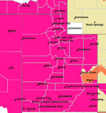
A Red Flag Warning is issued when the combination of dry fuels and weather conditions support extreme fire danger.
The warning means that critical fire weather conditions are either occurring now or are imminent. A combination of strong winds, low relative humidity, and warm temperatures can
contribute to extreme fire behavior.
No further information is available at this time.
Copyright 2024 Nexstar Media, Inc. All rights reserved. This material may not be published, broadcast, rewritten, or redistributed.
For the latest news, weather, sports, and streaming video, head to ABC4 Utah.
