Sunshine returns – a nice weekend of weather ahead!
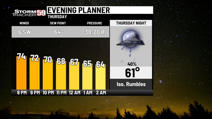
Tonight features a slow decrease in cloud cover, with patchy fog expected after midnight. A stray shower can’t be ruled out early. We’ll see temperatures dip back into the low 60s.
Friday finally dries us out a good bit, as high pressure noses in from the north across the Great Lakes and provides a little drop in humidity for us. An isolated shower still can’t be ruled out in our southern counties with our front close to the Virginia/North Carolina border, but most will be dry with partly sunny skies and highs in the low 80s.
Should you switch your thermostat to ’emergency heat’?

Saturday is also pretty dry overall with just an isolated chance for a brief shower or two with Thursday’s cold front stalling down to our south across the Virginia/North Carolina border and a weak area of low pressure scooting along that front. Partly sunny skies are expected with highs in the low to mid 80s.
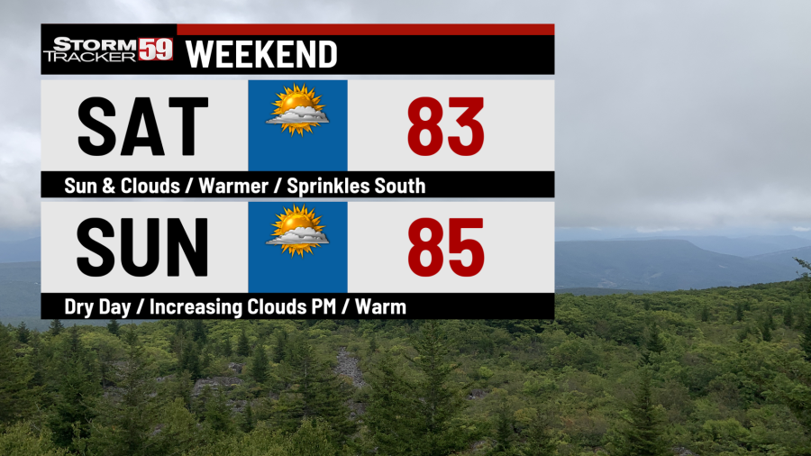
Sunday provides mostly sunny skies with high pressure nearly directly overhead, with high temperatures in the mid 80s.
Monday sees the return of the humidity as high pressure slides east. This will create the risk for afternoon scattered showers and storms with the combination of heat and humidity. In addition, an upper level low pressure system will stall over the northeast, enhancing our chances for rain. High temperatures will be in the mid 80s.
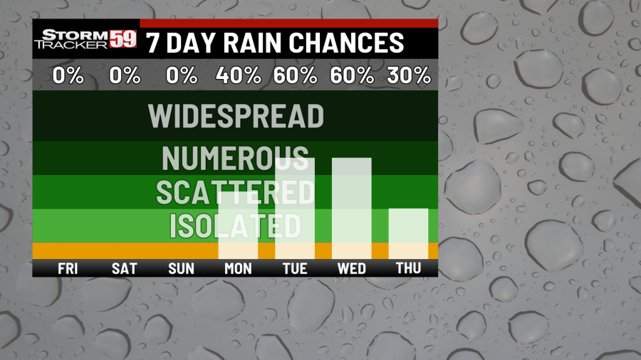
Tuesday continues our soggy pattern, which will last through much of next week, with scattered showers and perhaps a few rumbles likely. Some of those showers could be heavy with highs in the low 80s.
Can I get seasonal depression in the summer?
Wednesday will also feature unsettled weather with scattered showers and a rumble or two possible with highs in the low to mid 80s.
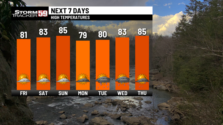
Thursday continues the unsettled pattern with scattered downpours expected and high temperatures once again in the 80s.
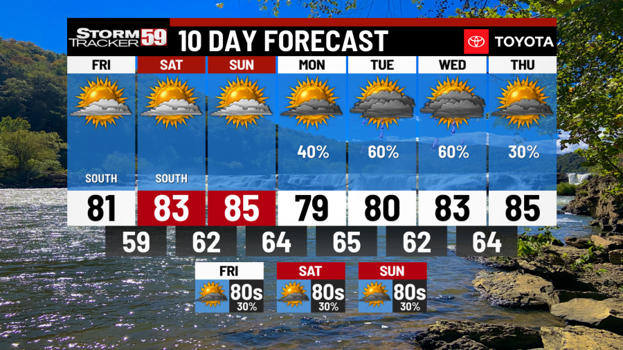
Looking ahead in your extended forecast, it’s a continued unsettled pattern. This pattern is good in terms of trying to improve drought conditions in the region, but it also will help keep temperatures from being any hotter – we have a pretty warm air mass in place next week but the abundant showers will keep high temperatures held down into the 80s. Chances for isolated to scattered showers will continue Friday into Saturday and even into Sunday with highs in the 80s.
TONIGHT
Clearing skies, patchy fog. Lows in the low 60s.
FRIDAY
Partly sunny with an isolated shower chance south. Highs in the low 80s.
SATURDAY
Just a brief isolated shower in the afternoon in our southern counties possible, otherwise partly sunny. Highs in the low to mid 80s.
SUNDAY
Mostly sunny. Warmer. Nice break from the humidity! Highs in the mid 80s.
MONDAY
Scattered storms return. Highs in the mid 80s.
TUESDAY
Scattered storms likely. Highs in the low 80s.
WEDNESDAY
Scattered storms. Highs in the mid 80s.
THURSDAY
Scattered showers. Highs in the mid 80s.
FRIDAY
Isolated to widely scattered storms. Highs in the mid 80s.
SATURDAY
Scattered showers. Highs in the mid 80s.
SUNDAY
Scattered showers continue. Highs in the low 80s.
Copyright 2024 Nexstar Media, Inc. All rights reserved. This material may not be published, broadcast, rewritten, or redistributed.
For the latest news, weather, sports, and streaming video, head to WVNS.

