Thunderstorms with hail, severe winds expected in El Paso on Wednesday
Rain, wind and hail are expected to hit El Paso as more thunderstorms move into the area on Wednesday, June 10.
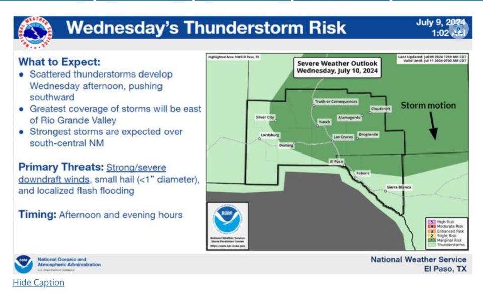
The afternoon storms could produce quarter-sized hail, severe winds and flash flooding, according to the National Weather Service.
It’s still early in the monsoon season — it began on June 15 and runs through Monday, Sept. 30 — but unexpected moisture levels in the atmosphere are impacting rainfall levels in the region.
While most flooding happens in mountain areas, El Paso and Las Cruces experience flooding in lowland areas with poor draining, said Kerwyn Texeira with the National Weather Service.
El Paso can expect a marginal risk of thunderstorms, along with nearby Doña Ana County, according to a National Weather Service map.
The biggest threat to rainfall still lies in the areas impacted by recent wildfires.
“As of now, our main area of concern is in the Northern Sacramento Mountains due to the burn scar from recent fires,” Texeira said. “With a burn scar area, it would not take a lot of rainfall to cause flooding."
More: It's monsoon season, but when will it rain? Here's what National Weather Service said
More thunderstorms are expected on Thursday, July 11, before dry air moves in, according to the National Weather Service.
Rain chances dwindle on Friday, July 12 and Saturday, July 13, before moisture returns for more possible thunderstorms next week.
Ruidoso continues evacuations, closures
The village of Ruidoso urged some areas to evacuate on Tuesday, June 9. Residents were instructed to leave belongings and move to higher ground immediately. Due to flooding, all bridge crossings were also closed.
One video captured a woman stranded in her home while water rushed by just inches from her doorstep.
With more rain on the way, burn scars created by the South Fork and Salt Fires could make the situation even more dire. The village warned flooding could continue to be dangerous for residents living in downstream areas.
Sandbags available at El Paso Water distribution sites
El Paso Water announced its seasonal sandbag distribution centers are now open. Sandbags are free for residents who show a Texas ID or water bill.
Stormwater Operations Center: 4801 Fred Wilson Ave.; hours: Monday-Friday: 8 a.m.-8 p.m., Saturday-Sunday: 2 p.m.-8 p.m.
Artcraft Booster Station: 7830 Paseo Del Norte; hours: Monday-Sunday: 2 p.m.-8 p.m.
Black Chesher Park: 9292 Escobar Drive; hours: Monday-Sunday: 2 p.m.- 8 p.m.
This article originally appeared on El Paso Times: Monsoon season brings flash flooding risk to El Paso and Las Cruces

