Tornado watch issued for parts of Cincinnati. How Beryl could impact the area
3:32 p.m. from National Weather Service: A tornado watch is in effect from 3:05 p.m. July 9 until midnight.
Remnants of Tropical Depression Beryl is now forecast to push northeastward and to Ohio, causing unstable weather to move through Cincinnati on Tuesday.
The National Weather Service in Wilmington issued a tornado watch Tuesday afternoon for Butler, Clermont, Hamilton and Warren counties from 3:05 p.m. through midnight. The watch includes isolated hail up to a half-inch in size and isolated winds up to 70 mph.
[3:13 PM] A Tornado Watch has been issued that impacts our Tri-State until midnight. pic.twitter.com/4tero6cAuc
— NWS Wilmington OH (@NWSILN) July 9, 2024
According to USA TODAY, Beryl has weakened from a tropical storm to a tropical depression as its center tracks inland over East Texas. The storm will likely merge with a front, bringing heavy rain and the chance for tornadoes to the Ohio Valley region.
The weather service also reports that scattered showers and possible thunderstorms are expected throughout the Cincinnati area into Tuesday night and early Wednesday morning. Isolated, weak tornadoes could also form in the afternoon and evening, per a hazardous weather outlook. Heavy rainfall cannot be ruled out at night.
There's an 80% chance of precipitation Tuesday afternoon into the evening, with showers and thunderstorms likely between 1-2 a.m. Wednesday morning.
Temperatures will reach a low around 70 degrees Tuesday night.
Showers and thunderstorms are possible Wednesday. Wind gusts could get up to 32 mph. Temperatures on Wednesday will be cooler, as the high will be near 75.
Beryl remnants will move northeast of the area Wednesday night. Rain chances will reduce overnight. Cooler, drier air will move into the Ohio Valley region by Thursday. High temperatures and humidity will return by Friday.
How much rain could Cincinnati get on Tuesday?
Cincinnati could receive rainfall between a tenth and a quarter inch Tuesday, increasing to between a half and three quarters of an inch possible Tuesday night. Higher amounts are a possibility in thunderstorms.
As the remnants of Beryl begin to approach the region there will be the potential for severe weather on Tuesday. The highest chance for severe weather will be from around 3pm-midnight. Isolated weak tornadoes will be the main threat. Gusty winds then possible on Wednesday. pic.twitter.com/YDLZNiiGBi
— NWS Wilmington OH (@NWSILN) July 8, 2024
Beryl circling toward East Coast. How could it affect Ohio?
Heavy rain and potential flooding are the biggest concerns as the storm circles toward the East Coast.
"Widespread heavy rains and thunderstorms are likely along and to the northeast of the path of Beryl over the next two days," the NWS told USA TODAY.
"The storm's tentacles will even reach Canada by late in the week," AccuWeather meteorologist Bill Degar told USA TODAY.
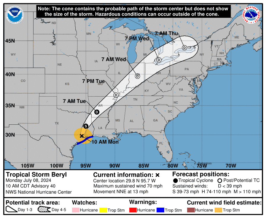
Tropical Depression Beryl path tracker: Will hurricane remnants affect Ohio?
This forecast track shows the most likely path of the center of the storm. It does not illustrate the full width of the storm or its impacts, and the center of the storm is likely to travel outside the cone up to 33% of the time.
Tropical Depression Beryl spaghetti models: Where will Hurricane Beryl remnants go next? Is Ohio in the path?
Illustrations include an array of forecast tools and models, and not all are created equal. The hurricane center uses only the top four or five highest-performing models to help make its forecasts.
See Beryl grow from tropical depression to Category 5 storm
Hurricane Beryl timeline: From tropical depression to Category 5 storm
June 28, 5 p.m.: Tropical Depression 2 forms in Central Atlantic, about 1,225 miles east-southeast of Barbados. Winds at 35 mph.
June 28, 11 p.m.: Tropical Storm Beryl forms about 1,110 miles east-southeast of Barbados. Winds at 40 mph.
June 29, 5 p.m.: Beryl becomes first hurricane of 2024 season 720 miles east-southeast of Barbados. Winds at 75 mph.
June 30, 8 a.m.: Beryl becomes Category 3 hurricane 420 miles east-southeast of Barbados. Winds at 115 mph.
June 30, 11:35 a.m.: Beryl now a Category 4 hurricane 350 miles east-southeast of Barbados. Winds at 130 mph.
July 1, 11:10 a.m.: Landfall No. 1. Beryl makes landfall as Category 4 hurricane at Carriacou Island, Grenada. Winds at 150 mph.
July 1, 11 p.m.: Beryl becomes Category 5 hurricane in eastern Caribbean. Winds at 160 mph.
July 2, 2 a.m.: Beryl strengthens even more in eastern Caribbean. Winds hit 165 mph.
July 2, 2 p.m.: Beryl weakens slightly as the eye passes south of the Dominican Republic. Winds at 155 mph.
July 3, 5 p.m.: Eyewall of Beryl brushes south coast of Jamaica. Winds at 140 mph.
July 4, 8 a.m.: Center of Beryl passes southwest of Grand Cayman Island. Winds at 120 mph.
July 4, 9:30 p.m.: Beryl strengthens back to Category 3 storm as it approaches Yucatan Peninsula. Winds at 115 mph.
July 5, 6:05 a.m.: Landfall No. 2: Beryl makes landfall on Yucatan Peninsula northeast of Tulum, Mexico as a Category 2 storm. Winds at 110 mph.
July 5, 1 p.m. CDT: Beryl weakens into tropical storm as it moves over Mexico. Winds at 70 mph.
July 5, 10 p.m. CDT: Beryl enters Gulf of Mexico as tropical storm. Winds at 60 mph.
July 7, 11 p.m. CDT: Beryl become a hurricane again 65 miles south-southeast of Matagorda, Texas. Winds at 75 mph.
July 8, 4 a.m.: CDT: Landfall No. 3. Beryl makes landfall near Matagorda, Texas, as Category 1 storm. Winds at 80 mph.
Contributing: Gabe Huari, Doyle Rice, Thao Nguyen, Cheryl McCloud, Christopher Cann, Cybele Mayes-Osterman, Jorge L. Ortiz and Michael Loria, USA TODAY.
This article originally appeared on Cincinnati Enquirer: Tropical Depression Beryl: Will storm bring tornadoes to Cincinnati?

