Tornado watch issued for parts of New Hampshire, Maine, Massachusetts until 8 p.m.
CONCORD — The National Weather Service in Gray, Maine, warns residents and visitors in New Hampshire that there is an enhanced risk for severe storms Sunday.
At about 1 p.m., a tornado watch was issued for parts of Maine, Massachusetts, New Hampshire, New York and Vermont until 8 p.m. by the National Weather Service in Gray, Maine. A tornado watch means current weather conditions could lead to a tornado, and you should be prepared to move to shelter. A warning means a tornado is occurring or about to happen, seek shelter immediately.
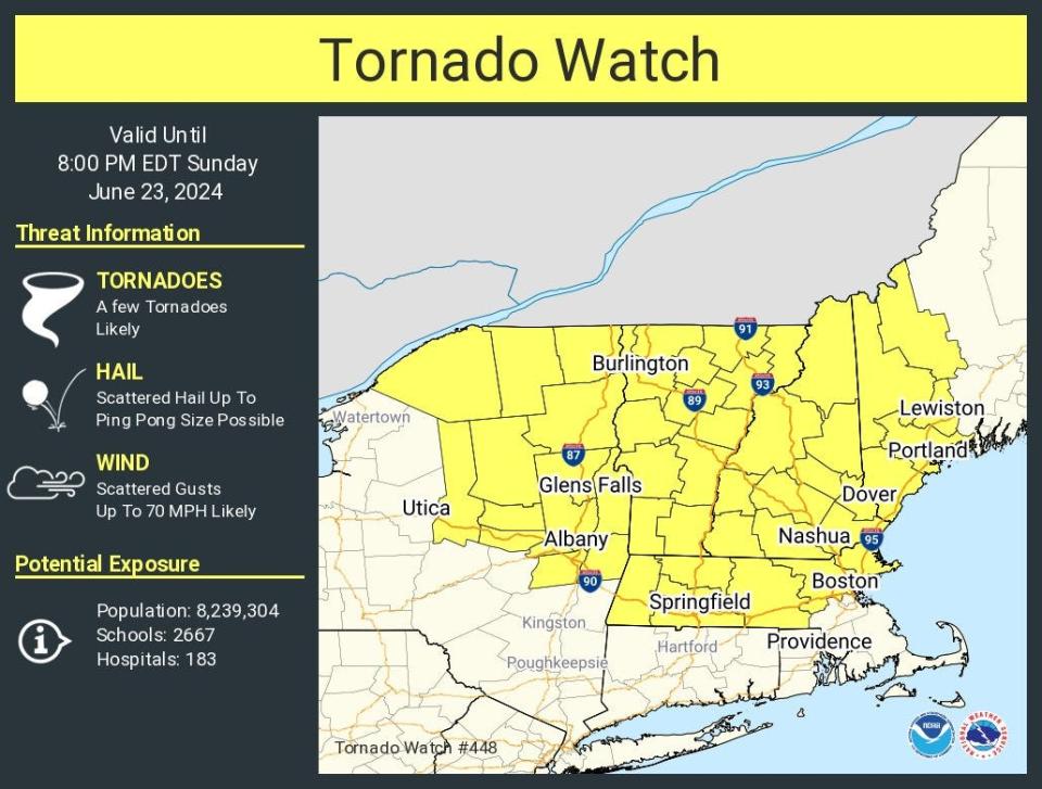
According to the National Weather Service in Gray, Maine, thunderstorms are expected to develop between 2 to 4 p.m. and move southeast across the area through the evening by 9 p.m.
The New Hampshire Department of Safety’s Division of Homeland Security and Emergency Management urges residents and visitors to prepare now for the possibility of damaging winds, isolated tornadoes, hail, and flash flooding.
“Stay informed to keep you and your family safe,” said HSEM Director Robert Buxton. “Review your family emergency plan now and make sure your emergency kit is stocked. Your kit should include important documents and contact information along with supplies.”

The NWS said there is the potential for winds over 70 mph, and the Storm Prediction Center has issued a 10% risk for tornadoes across New Hampshire for Sunday.
Campers should have a way to be aware of changing conditions and be prepared to evacuate to higher ground immediately if flooding occurs. Campers also should have a plan for alternative shelter if needed.
The state Department of Safety’s Division of Homeland Security and Emergency offers the following safety recommendations:
Have multiple ways to receive weather alerts. Monitor storm updates from the NationalWeather Service and local news stations. Sign up for NH Alerts and download the GenasysProtect mobile app to receive free emergency notifications.
If flooding occurs get to higher ground immediately. Just 6 inches of moving water can knockyou down, and 1 foot of water can sweep your vehicle away.
If driving in a vehicle, remember the saying, “turn around, don’t drown.”
If floodwaters rise around your car but the water is not moving, abandon the car and move tohigher ground. Do not leave the car and enter moving water. Just 6 inches of water can reachthe bottom of most passenger cars causing loss of control and possible stalling.
Prepare your home: Trim trees that may fall and cause damage.
Tie down or bring indoors any objects that might be blown around by winds (outdoorfurniture, decorations, garbage cans, and other loose objects that are normally left outside).
Follow instructions from local emergency officials and know how to safely evacuate shouldyou be told to do so.
Find the latest road conditions at newengland511.org.Learn more about staying informed, having a plan and making a kit as well as the actions to take for different severe weather events online at ReadyNH.gov.Stay informed by following New Hampshire Homeland Security and Emergency Management on Facebook, X, formerly Twitter, (@NH_HSEM) and Instagram (@NH_HSE.
Unitil readies for potential outages
Unitil Corporation announced Sunday they are prepared to respond to outages in all service regions as potentially severe thunderstorms pass through this afternoon and tonight.
According to the most recent forecast, wind gusts of 40-65 miles per hour or more are possible within the most powerful storm cells today, with isolated chances of tornado activity possible as well. High winds have the potential to take down otherwise healthy tree limbs and branches into poles and wires, causing outages.
Unitil secured additional crews in advance of the storm and will have teams ready to respond in all regions during the expected peak activity.
“Thunderstorm activity in the late spring and early summer is fast moving and has the potential to deliver extremely hazardous conditions with little to no advance warning,” Unitil External Affairs Director Alec O’Meara said. “We recognize conditions are ripe for such activity today, and we are prepared to react should any area see the worst of what is forecasted.”
Unitil will be communicating throughout the event through Public Service Announcements (PSAs), their website, customer call center and through the media. They also encourage customers to follow along with their storm updates via Facebook, Twitter feed (@Unitil) and will provide real-time outage information online at unitil.com/map.
This article originally appeared on Portsmouth Herald: Tornado watch issued for parts of New Hampshire, Maine, Massachusetts

