Tracking the Tropics: Beryl strengthens into Category 5 hurricane
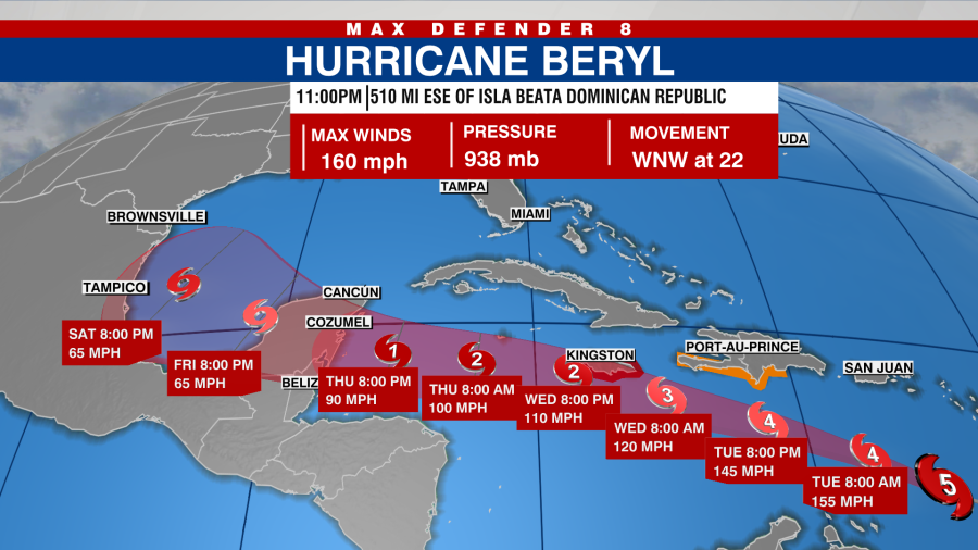
TAMPA, Fla. (WFLA) — Hurricane Beryl has strengthened into a Category 5 hurricane, according to the National Hurricane Center.
Hurricane Beryl made landfall Monday on Carriacou Island as an “extremely dangerous” Category 4 storm.
As of 11 p.m., Beryl was located about 510 miles east-southeast of Isla Beata, Dominican Republic with maximum sustained winds of 160 mph, according to the NHC. It’s the earliest Category 5 storm on record.
In the video below, Max Defender 8 Meteorologist Rebecca Barry and WFLA Now’s J.B. Biunno break down the latest forecast track and how Beryl shattered the record for earliest Atlantic hurricane to reach Category 4 strength.
Hurricane Beryl
Beryl made landfall Monday on Carriacou Island as an “extremely dangerous” Category 4 hurricane with 150 mph winds.
The storm is the earliest Category 4 hurricane in the Atlantic on record.

The hurricane’s core will move away from the Windward Islands and across the southeastern and central Caribbean Sea late Monday through Wednesday, the NHC said. It is expected to pass Jamaica on Wednesday.
“Fluctuations in strength are likely during the next day or so, but Beryl is expected to remain an extremely dangerous major hurricane as its moves over the eastern Caribbean,” NHC forecasters wrote. “Some weakening is expected in the central Caribbean by midweek, though Beryl is forecast to remain a hurricane.”
Watches and warnings in effect
A Hurricane Watch is in effect for
Jamaica
A Tropical Storm Warning is in effect for:
South coast of Dominican Republic from Punta Palenque westward
to the border with HaitiSouth coast of Haiti from the border with the Dominican Republic to Anse d’Hainault
Hurricane Beryl is expected to bring dangerous storm surge, potentially catastrophic winds and flooding rains to the islands.
“There have been multiple reports of downed trees, flooded streets, power outages and storm surge flooding in the Grenandines, Grenada, Barbados, and Tobago,” NHC forecasters wrote.
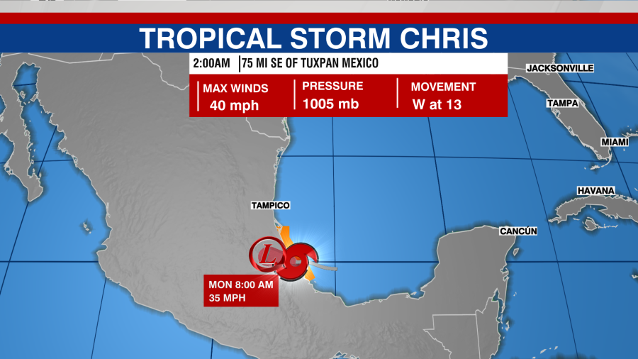
Remnants of Chris
Chris’ remnants are bringing heavy rainfall and flooding to portions of eastern Mexico, the National Hurricane Center said. Chris was downgraded from a tropical depression with maximum sustained winds near 35 mph.
Forecasters said Chris will continue farther inland over eastern Mexico through Monday. The storm dissipated over higher terrain on Monday.
Tropical Disturbance (AL96)
The National Hurricane Center is keeping an eye on an area of showers and thunderstorms about 1,000 miles west-southwest of the Cabo Verde Islands.
The system could develop into a tropical depression by the middle part of the week. It is moving westward at 15 to 20 mph across the central and western tropical Atlantic.
It has a 30% change of developing in the next 48 hours and a 60% chance of forming over the next seven days.
Copyright 2024 Nexstar Media, Inc. All rights reserved. This material may not be published, broadcast, rewritten, or redistributed.
For the latest news, weather, sports, and streaming video, head to PIX11.

