Tropical Storm Alberto to drench coastal Texas, Mexico, make landfall Thursday, NHC says
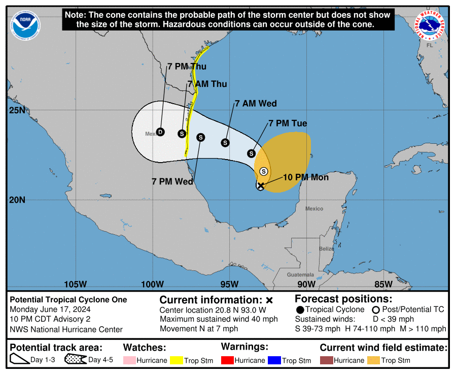
Tropical Storm Alberto, the first named tropical storm of the 2024 Atlantic hurricane season, is pounding the coasts of Texas and northeastern Mexico with heavy rains, coastal flooding and gusty winds, according to the latest advisory from the National Hurricane Center. The center is expected to reach the coast of Mexico by early Thursday.
Meanwhile, the NHC is tracking two more disturbances in the Gulf of Mexico and the southwestern Atlantic Ocean off the coast of Florida.
Storm sequel on horizon? Alberto targets Texas, 'featherweight' system nears Florida
“Alberto is the first of many named storms we’re expecting this hurricane season, I’m afraid,” said AccuWeather Chief On-Air Meteorologist Bernie Rayno in an email. “Alberto is about 275 miles southeast of Brownsville, Texas at the time it strengthened to a tropical storm. All morning we could see clouds gathering around the center of circulation, especially on the southern side where we saw a blowup of thunderstorms.”
Tropical storm warnings have been issued for the Texas coast from San Luis Pass southward to the mouth of the Rio Grande and for the northeastern coast of Mexico.
Alberto has already caused flooding and more than 3 feet of storm surge in parts of coastal south Texas, according to AccuWeather.
“Even though the center of circulation is south of Texas, it has a pretty large circulation. That’s why we’re seeing impacts in coastal and southern Texas. There are going to be bands of heavy rain in Corpus Christi today with thunder and lightning,” Rayno said. “Austin and San Antonio are going to get soaking rains this afternoon and tonight. Corpus Christi, Brownsville, and parts of the Rio Grande Valley will be drenched with 8 to 12 inches of rain. This is an impactful tropical storm. It’s not making landfall in the United States, but it’s certainly having big impacts in Texas.”
Forecasters predict potentially life-threatening flooding and mudslides in and near areas of higher terrain across the Mexican states of Coahuila, Nuevo Leon, and Tamaulipas. Swells generated by the disturbance will affect the coast of Louisiana and Texas as well as northeastern Mexico through early Thursday. These swells are likely to cause life threatening surf and rip current conditions.
Meanwhile, forecasters still have their eyes on a low-pressure area off the east coast of Florida with a low chance of development.
"This appears to be a quick-moving and compact low-pressure area that will be moving westward into northeastern Florida or perhaps as far north as southeastern Georgia on Thursday," AccuWeather Senior Meteorologist Dan Pydynowski said. The storm's speed limits its development potential but it still could bring more rain, gusty winds and dangerous surf to the southeast Atlantic coast, forecasters said.
Another broad area of low pressure is forecast to develop over the southwestern Gulf of Mexico this weekend, the NHC said and it could gradually develop through early next week.
➤ Track Tropical Storm Alberto
Here's the latest update from the NHC as of 5 p.m., June 19:
Tropical Storm Alberto
Special note on the NHC cone: The forecast track shows the most likely path of the center of the storm. It does not illustrate the full width of the storm or its impacts, and the center of the storm is likely to travel outside the cone up to 33% of the time.
Location: About 170 miles east of Tampico, Mexico and 305 miles south-southeast of Brownsville, Texas
Maximum wind speed: 40 mph
Direction: West-southwest at 9 mph
Forecast, impact: Tropical Storm Alberto getting closer to Mexico. See spaghetti models
Spaghetti models for Tropical Storm Alberto
➤ Track Tropical Storm Alberto
Special note about spaghetti models: Illustrations include an array of forecast tools and models, and not all are created equal. The hurricane center uses only the top four or five highest performing models to help make its forecasts.
What is out there and how likely are they to strengthen?
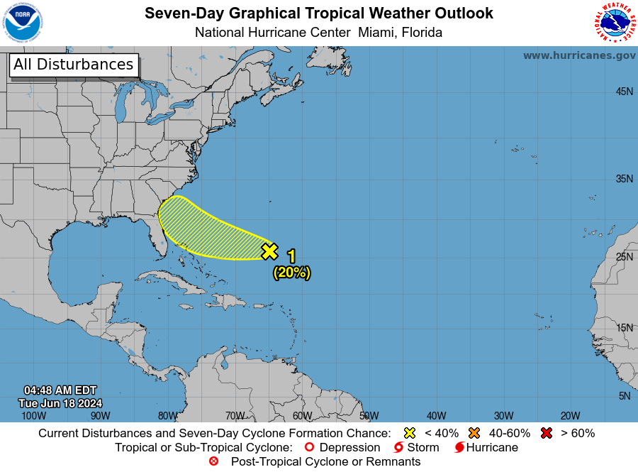
Southwestern Atlantic:
An area of showers and thunderstorms located a few hundred miles east of the Bahamas is associated with a surface trough of low pressure. Environmental conditions are marginally conducive for some gradual development of this system during the next few days while it moves westward or west-northwestward. The system is forecast to approach the coast of the southeastern United States by Friday.
Formation chance through 48 hours: low, 20 percent.
Formation chance through 7 days: low, 20 percent.
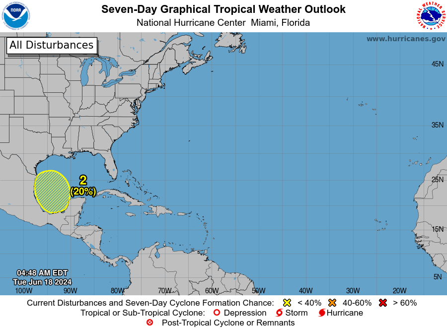
Southwestern Gulf of Mexico:
Another broad area of low pressure is forecast to develop over the southwestern Gulf of Mexico this weekend. Environmental conditions are expected to be conducive for gradual development of this system through early next week while it moves slowly west-northwestward or northwestward.
Formation chance through 48 hours: low, near 0 percent.
Formation chance through 7 days: low, 30 percent.
Who is likely to be impacted?
Tropical Storm Alberto is expected to produce rainfall totals of 5 to 10 inches across northeast Mexico into South Texas, with maximum totals of 20 inches possible. This rainfall will likely produce considerable flash and urban flooding along with new and renewed river flooding. Mudslides are also possible in areas of higher terrain across northeast Mexico.
Tropical storm conditions are expected within the warning area Wednesday. A couple of tornadoes are possible Wednesday into the evening across parts of Deep South Texas and Southeast Texas. Swells generated by the disturbance will affect the coast of Texas and northeastern Mexico through early Thursday.
Forecasters urge all residents to continue monitoring the tropics and to always be prepared. That advice is particularly important for what is expected to be a very active hurricane season.
Weather watches and warnings issued in Florida
When is the Atlantic hurricane season?
The Atlantic hurricane season runs from June 1 through Nov. 30.
When is the peak of hurricane season?
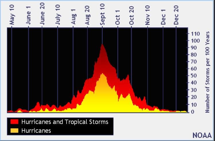
The peak of the season is Sept. 10, with the most activity happening between mid-August and mid-October, according to the Hurricane Center.
National Hurricane Center map: What are forecasters watching now?
Systems currently being monitored by the National Hurricane Center include:
Interactive map: Hurricanes, tropical storms that have passed near your city
Excessive rainfall forecast
What's next?
We will continue to update our tropical weather coverage daily. Download your local site's app to ensure you're always connected to the news. And look for our special subscription offers here.
This article originally appeared on Treasure Coast Newspapers: Tropical Storm Alberto becomes 1st named storm in 2024 hurricane season

