Tropical Storm Beryl could develop this weekend. See spaghetti models for Invest 95L
- Oops!Something went wrong.Please try again later.
In less than 24 hours, a disturbance has gone from being a tropical wave that first appeared on the National Hurricane Center tropical outlook map to now showing potential of becoming the season's next named storm, according to the latest advisory.
Designated as Invest 95L, the tropical wave in the eastern Atlantic is moving quickly to the west. Forecasters said a tropical depression or tropical storm is likely to form this weekend
➤ Spaghetti models for Invest 95L
➤ Spaghetti models for Invest 94L
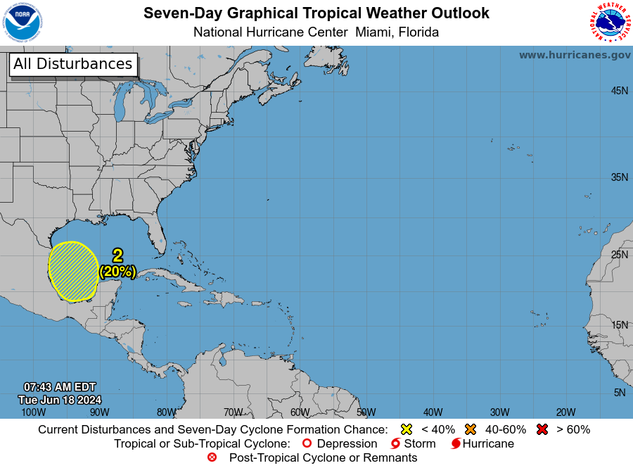
Closer to the U.S. is Invest 94L, a tropical wave with a low chance for development as it moves west in the west-central Caribbean Sea.
The next storm of the season will be Beryl.
Early July typically quiet in tropics. When could activity increase?
While Saharan dust moving west over the Atlantic makes it difficult for storms to develop and strengthen, there's still a chance for development of the system closer to the United States.
"A vast area of dry air, wind shear and an expanding shield of dust from the Sahara Desert in Africa will be the main deterrents for tropical development into the first part of July," AccuWeather Lead Tropical Meteorologist Alex DaSilva said.
"The historical average for named tropical systems through mid-July is only two, with the first during mid to late June," DaSilva said, "so historically you only get one more named system over the next two to three weeks, and we don't see much out there to differentiate against that at this time."
Tropical waves of low pressure will continue to roll west from Africa in the coming weeks and on through the heart of the Atlantic hurricane season into the early autumn, according to AccuWeather.
"Around the July Fourth holiday, some information suggests one of those tropical waves may become a little more robust as it approaches the Lesser Antilles in the eastern Caribbean," DaSilva said.
Busy hurricane season expected in 2024
Every forecast for the 2024 Atlantic hurricane season is predicting an above-normal season. The average number of named storms in a season is 14. AccuWeather forecasters have gone as far as saying 2024 could break the record of 30 named storms.
The presence of La Niña is a big factor in why every forecasting agency has been predicting a very active Atlantic hurricane season this year.
It doesn't help we're seeing record warm water temperatures in the Atlantic, which also provide fuel for tropical cyclones.
NOAA said May 2024 was the 14th consecutive month of record-warm global ocean temperatures.
Here's the latest update from the NHC as of 8 a.m. June 27:
Where is Invest 95L? Will it become Tropical Storm Beryl?
Invest 95L: A tropical wave located several hundred miles west-southwest of the Cabo Verde Islands continues to produce disorganized shower and thunderstorm activity.
Environmental conditions are forecast to be conducive, and development of this system is anticipated.
A tropical depression or tropical storm is likely to form this weekend several hundred miles east of the Windward Islands while the system moves westward at 15 to 20 mph.
Formation chance through 48 hours: medium, 40 percent.
Formation chance through 7 days: high, 70 percent.
Spaghetti models for Invest 95L
Can't see the map? Open in a new browser.
Special note about spaghetti models: Spaghetti model illustrations include an array of forecast tools and models, and not all are created equal. The hurricane center uses only the top four or five highest performing models to help make its forecasts.
Jim Cantore describes Invest 95L as 'very unusual tropical wave'
Meanwhile in the tropics... Very unusual tropical wave to move across the Main Development Region (MDR) potentially unscathed and potentially becoming an issue for the Windward Islands on Monday. Now invest #95L( lower right side of satellite loop) sitting down around 10N33W,… pic.twitter.com/o721lqFvAx
— Jim Cantore (@JimCantore) June 27, 2024
"Meanwhile in the tropics ... Very unusual tropical wave to move across the Main Development Region (MDR) potentially unscathed and potentially becoming an issue for the Windward Islands on Monday, The Weather Channel meteorologist Jim Cantore tweeted.
"Now invest #95L (lower right side of satellite loop) sitting down around 10N33W, its moving along steered by the Atlantic subtropical ridge. The positions of the subtropical ridge and any weakness in them is a low confidence forecast beyond early next week. The intensity of 95L will also be a key to where it eventually goes next week. Keep an eye on it."
Where is Invest 94L? Will it become tropical storm?

Invest 94L: A tropical wave over the western Caribbean Sea is producing widespread but disorganized shower and thunderstorm activity while it moves westward at around 20 mph.
Some development of this system is possible over the northwestern Caribbean Sea or over the southwestern Gulf of Mexico during the next several days.
Formation chance through 48 hours: low, low 10 percent.
Formation chance through 7 days: low, 30 percent.
Spaghetti models for Invest 94L
Can't see the map? Open in a new browser.
Special note about spaghetti models: Spaghetti model illustrations include an array of forecast tools and models, and not all are created equal. The hurricane center uses only the top four or five highest performing models to help make its forecasts.
What else is out there and how likely is it to strengthen?
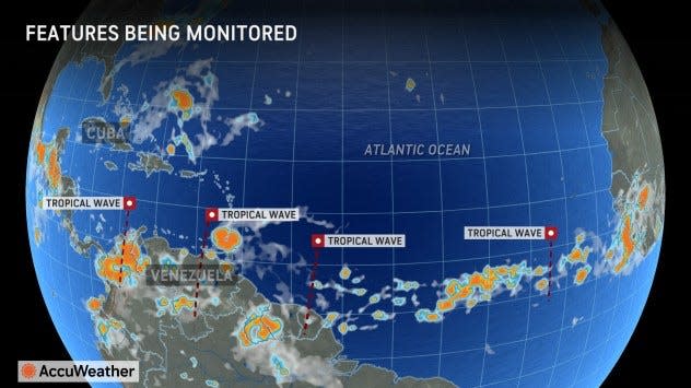
The National Hurricane Center is keeping an eye on three tropical waves, which includes Invests 94L and 95L. Here's where the third tropical wave is located:
Central Atlantic tropical wave: This tropical wave is moving west at 6 to 11 mph.
Who is likely to be impacted?
It's too early at this time to determine if there will be any impact to Florida or the U.S. from the tropical waves.
Forecasters urge all residents to continue monitoring the tropics and to always be prepared. That advice is particularly important for what is expected to be a very active hurricane season.
Weather watches and warnings issued in Florida
When is the Atlantic hurricane season?
The Atlantic hurricane season runs from June 1 through Nov. 30.
When is the peak of hurricane season?
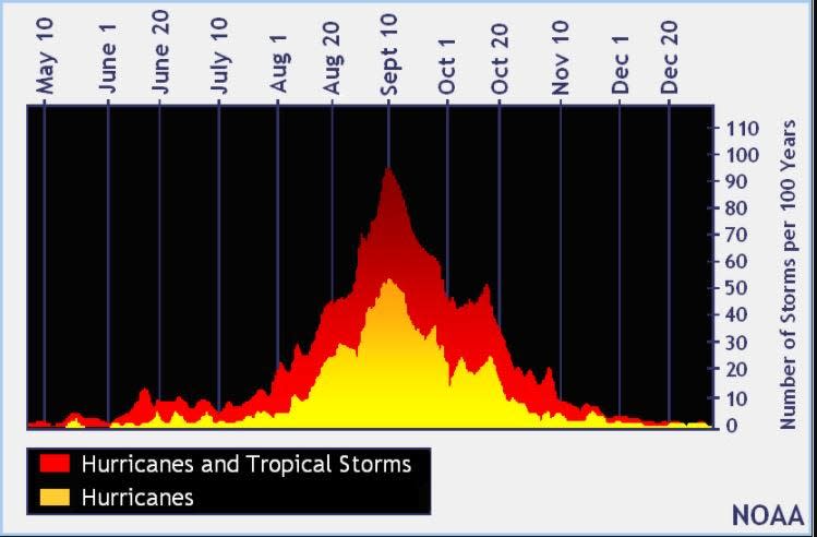
The peak of the season is Sept. 10, with the most activity happening between mid-August and mid-October, according to the Hurricane Center.
National Hurricane Center map: What are forecasters watching now?
Systems currently being monitored by the National Hurricane Center include:

Interactive map: Hurricanes, tropical storms that have passed near your city
Excessive rainfall forecast
What's next?
We will continue to update our tropical weather coverage daily. Download your local site's app to ensure you're always connected to the news. And look for our special subscription offers here.
This article originally appeared on Treasure Coast Newspapers: NHC tracking 3 tropical waves. Invest 95L Tropical Storm Beryl

