Beryl strengthens to become first hurricane of the season. It could be Category 3 soon
Hurricane Beryl formed on Saturday afternoon — breaking a storm record — and is forecast to intensify quickly as it continues to approach the Windward Islands. It may strengthen into a “dangerous” major hurricane.
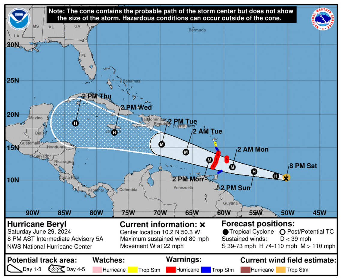
Here’s the latest from the National Hurricane Center’s Saturday 8 p.m. advisory.
Beryl’s wind speed: Beryl’s packing 80 mph sustained winds, shooting up from 65 mph in Saturday’s 2 p.m. advisory, with higher gusts. Hurricane force winds blow up to 10 miles from Beryl’s center, with tropical storm force winds extending 60 miles.
“Rapid strengthening is now forecast, and Beryl is expected to become a major hurricane before it reaches the Windward Islands,” the hurricane center said.
Where Beryl is and where Beryl is going: The storm is about 660 miles east-southeast of Barbados and moving west at 22 mph, swift for a storm.
“Continued steady to rapid strengthening is forecast, and Beryl is expected to become a dangerous major hurricane before it reaches the Windward Islands,” the hurricane center said.
Alerts: Barbados, St. Lucia, Grenada, St. Vincent and the Grenadine Islands are under a hurricane warning. Martinique and Tobago are under a tropical storm warning. There’s a tropical storm watch in effect for Dominica.
The rest of the Lesser Antilles “should closely monitor the progress of Beryl. Additional watches and warnings will likely be required for portions of this area later today.
Hazards: A “life-threatening storm surge” of 5 to 7 feet could hit the hurricane watch areas. Barbados and the Windward Islands could deal with 3 to 6 inches of rain Sunday and Monday with accompanying flooding. Puerto Rico may also see 1 to 4 inches of rain over its southeastern region. Deadly surf and rip current conditions could preclude water activities in the Windward and southern Leeward Islands.
Next Advisory: There will be a full advisory at 11 p.m. and an intermediate advisory at 2 a.m.
More on Beryl
Where Hurricane Beryl formed Saturday is the farthest east for a June hurricane in historical record. Only one other hurricane has formed anywhere nearby in June, and that was in 1933.
#Beryl is now a #hurricane - the farthest east that a hurricane has formed in the tropical Atlantic (<=23.5°N) in June on record, breaking the old record set in 1933. pic.twitter.com/ah9pow2G9a
— Philip Klotzbach (@philklotzbach) June 29, 2024
By Tuesday, the hurricane center noted that conditions could shift, and a strong subtropical ridge that is expected to keep the storm at lower latitudes could lighten, allowing Beryl to inch up into higher latitudes. While forecasters say it may strengthen to a Category 3, additional wind shear could help batter it back down a category or two.
Right behind Beryl, forecasters also are watching another system. This one, a tropical wave hundreds of miles southwest of the Cabo Verde Islands, had a growing shot at forming into a tropical depression or storm within the week.
As of the 8 p.m. update, forecasters gave it a 30% chance of strengthening into a depression over the next two days and a 70% chance in the next seven days.

