A tropical storm will likely form in the gulf. Here's what it may mean for Corpus Christi.
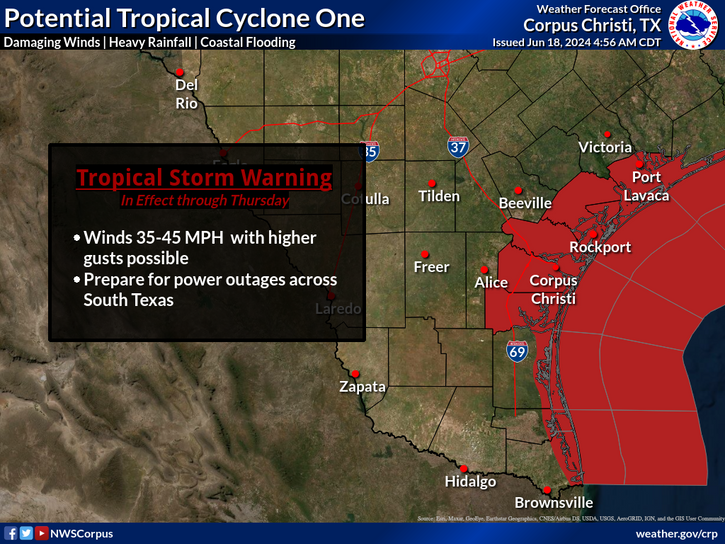
A tropical storm warning has been issued for Corpus Christi, as well as a large swath of coastal South Texas counties as a disturbance in the Gulf of Mexico reaches an 80% chance of formation by Wednesday, according to the National Hurricane Center.
Increased predicted rainfall | Updated 5:40 p.m.
The local office of the National Weather Service has bumped up predicted rain amounts along the coast.
It was initially forecast to be an estimated six- to eight inches.
A new forecast issued Tuesday evening on social media has increased it to a predicted eight- to 10 inches of rain through Thursday.
North Beach flooding | Updated 4:50 p.m.
Water has begun to make its way onto multiple streets on North Beach.
Located off the Corpus Christi Bay, the area frequently floods with high tides.
In an email, city of Corpus Christi officials listed the following roads as closed:
North Shoreline Boulevard, from Coastal Avenue to Bridgeport Avenue
Coastal Avenue, from North Shoreline Boulevard to Surfside Boulevard
Bridgeport Avenue, from North Shoreline Boulevard to Surfside Boulevard
Breakwater Avenue, North Shoreline Boulevard to Surfside Boulevard
Traffic on some of the other roads on North Beach have been temporarily reconfigured for traffic.
According to the email, those that have been converted from one-way to two-way include:
Surfside Boulevard, from Coastal Avenue to Pearl Avenue
Pearl Avenue, from Pearl Avenue to North Shoreline Boulevard
North Shoreline Boulevard, from Pearl Avenue to Bridgeport Avenue
NWS elaborates on threats faced in tropical storm warning | Updated 4:30 p.m.
In posts on the local National Weather Service social media, officials broke down some of the more specific threats that could be faced by much of the South Texas coast, including Corpus Christi, under the tropical storm warning.
They are intended to alert residents to prepare for the possibilities associated with the weather conditions.
According to NWS’ fact sheets on X:
Wind: 35 to 45 miles per hour, with potentially stronger gusts
Speeds may be strong enough to damage weaker structures – such as sheds and awnings – while travel may become hazardous due to debris blown into streets and from strong winds on more elevated roadways.
There is also a 2% chance of tornadoes when rain bands move on shore, said Cory Mottice, warning coordination meteorologist, in a Facebook live.
Water: Six to eight inches generally, with potential of 15 inches of rain in some places
Flooding water may rise enough to potentially enter some buildings, according to one of the NWS’ posts.
“Rivers and streams may quickly overflow in multiple places,” it states. “Streams, canals and ditches may become dangerous rivers.”
Oso Creek is projected to rise beginning Wednesday and reach a moderate flood stage of about 23 feet Thursday, according to an NWS graphic. It is currently less than seven feet.
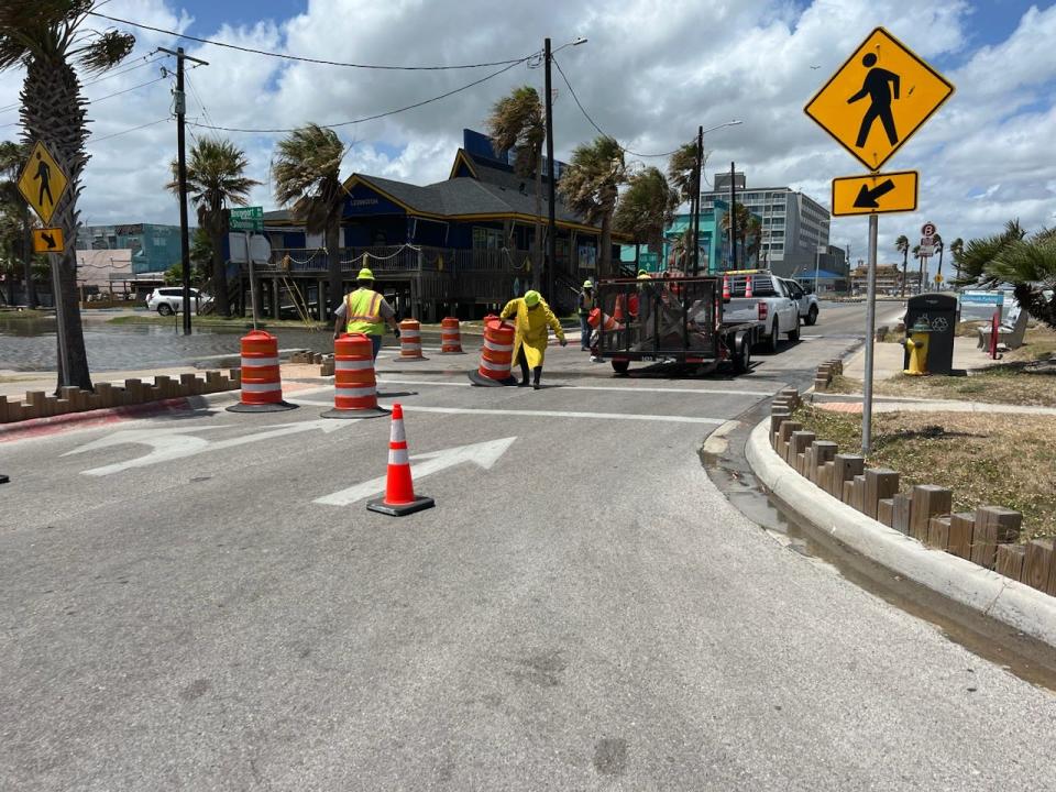
North Beach roads, gulf beach roads and jetty closures | Updated 2:30 p.m.
City of Corpus Christi beach access roads remain open with the exception of Access Road 3A where “a hole that has formed at the entrance of beach,” according to a memo sent by City Manager Peter Zanoni to the City Council.
Also closing is the gate to the Packery Channel Jetty walkway, where “conditions are deteriorating,” he wrote.
On North Beach, city crews are placing "traffic control devices to close roads already inundated with water surges from the Bay," Zanoni wrote.
In a Facebook message reposted by the local NWS, officials with Padre Island National Seashore wrote that closures were also underway at the national park.
“We have temporarily closed South Beach to vehicle traffic," reads the message. "Minor coastal flooding has already begun and is expected to increase with up to 3 feet of beach inundation expected through Thursday.”
City of Corpus Christi increases emergency level | Updated 10:30 a.m.
The city of Corpus Christi has elevated its emergency level from a level 4 to level 3, according to a Tuesday morning message from City Manager Peter Zanoni to the City Council.
The following are the city's emergency levels, according to his message.
"Level 1: an emergency is imminent or has occurred.
Level 2: an emergency exists which is very likely to occur.
Level 3: existence of a situation that may develop into an emergency but not an imminent threat.
Level 4: readiness to respond to any emergency that mat develop or occur."
City preparing for potential flooding
Residents within a broad area, including inland, should monitor the storm, meteorologists have said – and prepare for the potential of power outages, flooding and high winds.
A series of fact sheets on its website show that should a tropical depression or tropical storm develop out of what is presently a disturbance, it is likely to move westward into Mexico.
However, it is anticipated tropical storm conditions will likely reach far into Texas, from about Port O’Conner down to the U.S.-Mexico border.
“The disturbance is quite large with tropical-storm-force winds extending outward up to 290 miles (465 km) to the northeast of the center,” states an NHC fact sheet.
Should it reach full development, it would be the first tropical storm of the hurricane season. Its name would be Tropical Storm Alberto.
Corpus Christi
Coastal flooding
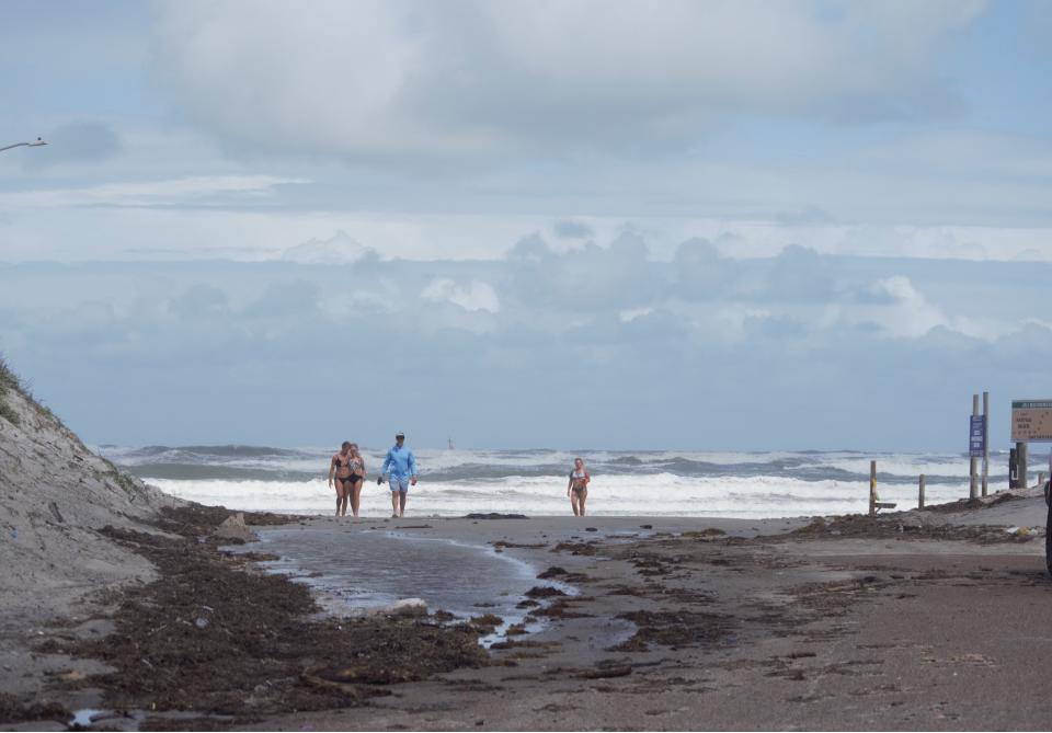
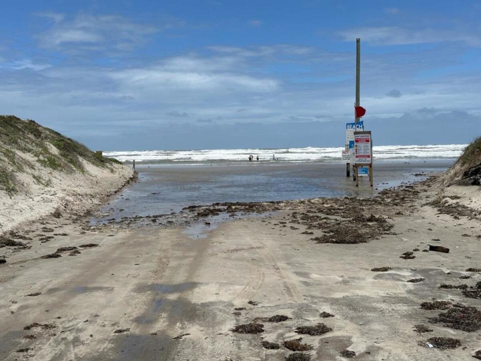
A coastal flood warning predicting beach inundation levels as high as three feet is in effect and will continue through Thursday morning, according to messages posted on the local NWS’ social media site, X.
Early images posted on the local NWS’ social media show video attributed to Sea Gulf Condominiums on Mike Ellis, North Padre Island, with waves touching the dunes.
As the sun comes up this morning, we can see how high tides have been overnight. Water is at the dunes along much of the coast. We're coming out of high tide, but waves will likely keep water high on the beach all the day. Even higher levels are expected tonight into tomorrow. pic.twitter.com/iKD4nQjjuZ
— NWS Corpus Christi (@NWSCorpus) June 18, 2024
The water is expected to close local beach access roads and likely cause some beach erosion, according to the local NWS.
City officials may also close the walkway on Packery Channel jetty, according to a memo sent by City Manager Peter Zanoni in a memo to the City Council on Monday afternoon.
Street, creek and river flooding
Between six- and eight inches of rain is predicted to fall within the next few days, with the heaviest from Tuesday afternoon or evening into the duration of Wednesday.
That is enough water to cause flooding in different areas of the city – aside from coastal flooding, flooding of roads and creeks.
Please see here for a list of roads prone to flooding.
Another area well-known to flood is Oso Creek, although flooding in that area often occurs after heavy rain instead of during.
There is at least a 40% chance of flash flooding in Corpus Christi and surrounding areas starting Tuesday and extending into Thursday, according to an NHC fact sheet.
Water tends to be a greater danger than wind in tropical storm events, according to the NWS.
City and state officials have frequently warned drivers not to drive around barricades.
More water-related deaths “occur due to flooding than from any other thunderstorm related hazard,” according to weather.gov, in part because “people underestimate the force and power of water.”
Vehicles driving into flood waters pose the highest mortality rate, followed by walking into flood water, according to a Centers for Disease Control and Prevention report cited by weather.gov.
“Never drive around the barriers blocking a flooded road. The road may have collapsed under that water,” the site states. “ A mere 6 inches of fast-moving flood water can knock over an adult. It takes just 12 inches of rushing water to carry away most cars and just 2 feet of rushing water can carry away SUVs and trucks.”
Wind
Between 35 to 45 mile per hour winds may accompany conditions in the Corpus Christi area, according to a local NWS map graphic, which warns that residents should “prepare for power outage across South Texas.”
How is the city responding?
City officials have created an action plan in anticipation of flooding.
City Manager Peter Zanoni, in a Monday afternoon memo to the City Council, wrote that North Beach may begin to see some coastal flooding by noon Tuesday.
Although Wednesday is Juneteenth – and while most of the city’s services are planned to be closed – “we will be requiring a number of employees to report to work including the majority of Public Works,” Zanoni wrote in his memo to the council.
The 3-1-1 call center – which takes nonemergency calls – and the emergency operations center are planned to be open Wednesday, as well, he wrote.
The Padre Island beaches will remain open, however the Packery Channel jetty walkway and nearby roads “may be closed following established safety protocols,” Zanoni added.
Elsewhere in the city, officials plan to pre-position barricades at roads known to flood, he told the Caller-Times late Monday afternoon.
It is also planned heavy vehicles will also be pre-positioned in the event of needed rescue, Zanoni added.
In a subsequent news release, city officials wrote that personnel were in process of maintenance on storm drains to keep them clear, while crews had already relocated city-owned items on the beach, such as lifeguard stands and trash cans.
The drought
As of Monday, combined levels of Lake Corpus Christi and Choke Canyon Reservoir – the primary water resources for Corpus Christi and the Coastal Bend region – stood at about 25.1%, according to city of Corpus Christi data.
It is considered Stage 2 drought.
The city has been in drought for about two years.
Between two and four inches of precipitation may reach the recharge areas, Zanoni wrote in his memo to the City Council on Monday.
Should the recharge zones receive between three and five inches of rain, it could raise the combined lake levels to 30%, he told the Caller-Times. However, Stage 2 drought restrictions remain in effect until the combined lake levels rise to about 40%.
This is a developing story. Check back to caller.com for updates.
This article originally appeared on Corpus Christi Caller Times: A tropical storm warning has been issued for Corpus Christi

