Tropical tracker: Timeline of storms in the 2024 Atlantic hurricane season
This story is part of the KXAN Data Hub, where numbers help tell the whole story.
We’ve created several data-driven stories and databases on topics including weather and climate, politics, education, sports and growth in Texas. Each story in the KXAN Data Hub is updated as new data becomes available.

Editor’s Note: The video above shows the latest from the KXAN First Warning Weather team.

AUSTIN (KXAN) — Each year, the Atlantic hurricane season officially runs from June 1 through Nov. 30. This year is expected to be very active, with the National Oceanic and Atmospheric Administration (NOAA) predicting an 85% chance of an above-average season.

Hurricane history: How many storms have made landfall in Texas?

Follow along as we track each storm throughout hurricane season.

Current storms

Hurricane Francine

1 p.m. update for Hurricane Francine

The latest National Hurricane Center forecast shows Francine remaining a Category 1 hurricane with maximum sustained winds at 90 mph. Earlier forecasts of the hurricane strengthening to a Category 2 will not be realized as the storm remains a Category 1 when it makes landfall tonight or very early Thursday. Regardless, the storm is still expected to be a strong storm bringing heavy rain, storm surge and strong winds to coastal areas, especially in Louisiana.

The upper Texas coast is no longer under a Tropical Storm Warning. The Hurricane Warning continues from the Cameron/Vermilion Line east to Grand Isle. The Storm Surge Warning extends from Cameron to the Mississippi/Alabama border and includes Vermilion Bay, Lake Maurepas and Lake Pontchartrain.

<em>The Texas coast no longer under any warnings</em>
The Texas coast no longer under any warnings

Heavy rain, gusty winds and coastal flooding will be possible along the entire Texas coastline beginning later on Tuesday through Thursday. The brunt of the impacts look to strike Louisiana where storm surge up to 10 feet is possible in some areas.

Storm Surge Potential (NHC)

At this time, impacts to Central Texas will be limited to a few showers and cloud cover Tuesday into Wednesday. Eastern counties will have the best odds at picking up a quick 0.1″-0.25″.

Infrared view of Hurricane Francine in the Gulf of Mexico on Sept. 11, 2024. (Courtesy NOAA)
  • Sept. 11, 1 p.m.: Francine remained a Category 1 hurricane about 95 miles southwest of Morgan City, Louisiana. The storm had maximum sustained winds of 90 mph and was moving northeast at 16 mph.

  • Sept. 11, 1 a.m.: Hurricane Francine reached its maximum intensity, with 90 mph winds.

  • Sept. 10, 7 p.m.: Tropical Storm Francine strengthened into a Category 1 hurricane about 150 miles east of the mouth of the Rio Grande River. Francine had maximum sustained winds of 75 mph and was moving northeast at 10 mph.

  • Sept. 10, 7 a.m.: A Hurricane Warning was issued for the Louisiana coast from Morgan City to Grand Isle.

  • Sept. 9, 4 p.m.: A Hurricane Warning was issued for the Louisiana coast from Sabine Pass to Morgan City.

  • Sept. 9, 10 a.m.: Tropical Storm Francine formed about 245 miles southeast of the mouth of the Rio Grande River. The storm had maximum sustained winds of 50 mph and was moving north-northwest at 5 mph.

Tropical Depression Seven

Tropical Depression Seven forecast track
Infrared view of Tropical Depression Seven after formation in the Atlantic Ocean on Sept. 11, 2024. (Courtesy NOAA)
  • Sept. 11, 10 a.m.: Tropical Depression Seven formed about 310 miles west of the Cabo Verde islands. The depression had maximum sustained winds of 35 mph and was moving west-northwest at 18 mph.


Previous storms

Hurricane Ernesto

Infrared view of Hurricane Ernesto on Aug. 15, 2024. (Courtesy NOAA)
  • Aug. 12, 4 p.m.: Tropical Storm Ernesto formed about 295 miles east-southeast of Antigua. The storm had maximum sustained winds of 40 mph and was moving west-northwest at 28 mph.

  • Aug. 14, 10 a.m.: Tropical Storm Ernesto strengthened into a Category 1 hurricane about 175 miles northwest of San Juan, Puerto Rico. Ernesto had maximum sustained winds of 75 mph and was moving northwest at 16 mph.

  • Aug. 15, 4 a.m.: A Hurricane Warning was issued for Bermuda.

  • Aug. 15, 10 p.m.: Ernesto strengthened into a Category 2 hurricane about 410 miles south-southwest of Bermuda. The storm had maximum sustained winds of 100 mph and was moving north-northeast at 14 mph.

  • Aug. 16, 10 p.m.: Ernesto was downgraded to a Category 1 hurricane, with maximum sustained winds of 90 mph. The storm was located about 65 miles south-southwest of Bermuda, and was moving north-northeast at 13 mph.

  • Aug. 17, 4 a.m.: Category 1 Hurricane Ernesto made landfall on Bermuda, with maximum sustained winds of 85 mph. The storm was moving north-northeast at 9 mph.

  • Aug. 17, 10 p.m.: Ernesto was downgraded to a tropical storm, with maximum sustained winds of 70 mph. The storm was located about 140 miles northeast of Bermuda and was moving north-northeast at 8 mph.

  • Aug. 18, 4 p.m.: Tropical Storm Ernesto strengthened into a Category 1 hurricane about 520 miles south of Halifax, Nova Scotia. Ernesto had maximum sustained winds of 75 mph and was moving north-northeast at 17 mph.

  • Aug. 19, 10 p.m.: Hurricane Ernesto became a post-tropical cyclone about 420 miles east-northeast of Cape Race, Newfoundland.

Hurricane Debby

Tropical Storm Debby forecast from NHC
  • Aug. 2, 10 p.m.: Tropical Depression Four formed in the Caribbean Sea, about 75 miles south of Caibarién, Cuba. The depression had maximum sustained winds of 30 mph and was moving west-northwest at 17 mph.

  • Aug. 3, 4 p.m.: Tropical Depression Four strengthened into Tropical Storm Debby about 70 miles northwest of Havana, Cuba. Debby had maximum sustained winds of 40 mph and was moving northwest at 15 mph. A Hurricane Warning was issued for the Florida coast from the Suwannee River to the Ochlockonee River.

  • Aug. 4, 4 p.m.: A Hurricane Warning was issued for the Florida coast between the Ochlockonee River and Indian Pass.

  • Aug. 4, 10 p.m.: Tropical Storm Debby strengthened into a Category 1 hurricane about 65 miles west-southwest of Cedar Key, Florida. Debby had maximum sustained winds of 75 mph and was moving north at 12 mph. A Hurricane Warning was issued for the Florida coast between the Suwannee River and Yankeetown.

  • Aug. 5, 1 a.m.: Hurricane Debby reached its maximum intensity, with 80 mph winds.

  • Aug. 5, 6 a.m.: Category 1 Hurricane Debby made landfall near Steinhatchee, Florida, with maximum sustained winds of 80 mph. The storm was moving north-northeast at 10 mph.

  • Aug. 5, 10 a.m.: Debby was downgraded to a tropical storm, with maximum sustained winds of 70 mph. The storm was located about 35 miles west of Lake City, Florida, and was moving north-northeast at 8 mph.

  • Aug. 8, 1 a.m.: Tropical Storm Debby made landfall near Bulls Bay, South Carolina, with maximum sustained winds of 50 mph. The storm was moving northwest at 5 mph.

  • Aug. 8, 4 p.m.: Tropical Storm Debby was downgraded to a tropical depression about 45 miles east of Charlotte, North Carolina, with maximum sustained winds of 35 mph.

  • Aug. 9, 5 a.m.: Tropical Depression Debby became a post-tropical cyclone about 110 miles north of Danville, Virginia.

Tropical Storm Chris

Tropical Storm Chris shortly before landfall on June 30, 2024.
  • June 30, 4 p.m.: Tropical Depression Three formed in the Gulf of Mexico, about 185 miles east-southeast of Tuxpan, Mexico. The depression had maximum sustained winds of 35 mph and was moving west at 12 mph.

  • June 30, 10 p.m.: Tropical Depression Three strengthened into Tropical Storm Chris about 105 miles east-southeast of Tuxpan, Mexico. Chris had maximum sustained winds of 40 mph and was moving west at 13 mph.

  • June 30, 11:50 p.m.: Tropical Storm Chris made landfall near Lechuguillas, Mexico, with maximum sustained winds of 40 mph.

  • July 1, 7 a.m.: Tropical Storm Chris was downgraded to a tropical depression about 60 miles south-southwest of Tuxpan, Mexico, with maximum sustained winds of 35 mph.

  • July 1, 10 a.m.: Tropical Depression Chris dissipated about 60 miles south-southwest of Tuxpan, Mexico.

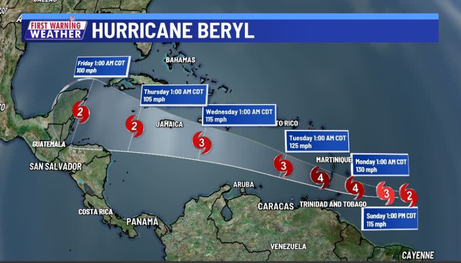
Hurricane Beryl

Infrared view of Hurricane Beryl making landfall on Carriacou Island, Grenada, as a Cat. 4 hurricane on July 1, 2024. (Courtesy NOAA)
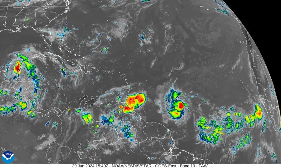
  • June 28, 4 p.m.: Tropical Depression Two formed about 1,225 miles east-southeast of Barbados. The storm had maximum sustained winds of 35 mph and was moving west at 21 mph.

  • June 28, 10 p.m.: Tropical Depression Two strengthened into Tropical Storm Beryl about 1,110 miles east-southeast of Barbados. Beryl had maximum sustained winds of 40 mph and was moving west at 18 mph.

  • June 29, 4 p.m.: Tropical Storm Beryl strengthened into a Category 1 hurricane about 720 miles east-southeast of Barbados. Beryl had maximum sustained winds of 75 mph and was moving west at 22 mph.

  • June 30, 4 a.m.: Beryl strengthened into a Category 2 hurricane about 465 miles east-southeast of Barbados. The storm had maximum sustained winds of 100 mph and was moving west at 21 mph. Hurricane Warnings were issued for Barbados, Grenada, St. Lucia and St. Vincent and the Grenadines.

  • June 30, 7 a.m.: Beryl strengthened further into a major Category 3 hurricane about 420 miles east-southeast of Barbados. The storm has maximum sustained winds of 115 mph and was moving west at 21 mph. A Hurricane Warning was also issued for Tobago.

  • June 30, 10:35 a.m.: Beryl strengthened into a Category 4 hurricane about 350 miles east-southeast of Barbados. The storm had maximum sustained winds of 130 mph and was moving west at 21 mph. Beryl became the first Category 4 hurricane on record in the Atlantic Basin in June.

  • July 1, 1 a.m.: Beryl is downgraded to a Category 3 hurricane about 110 miles south-southeast of Barbados. The storm had maximum sustained winds of 120 mph and was moving west at 20 mph.

  • July 1, 7 a.m.: Beryl re-strengthened into a Category 4 hurricane about 70 miles east of Grenada. The storm had maximum sustained winds of 130 mph and was moving west-northwest at 20 mph.

  • July 1, 10:10 a.m.: Category 4 Hurricane Beryl made landfall on Carriacou Island, in the island nation of Grenada, with maximum sustained winds of 150 mph. The storm was moving west-northwest at 20 mph.

  • July 1, 10 p.m.: Beryl strengthened into a Category 5 hurricane, making it the earliest hurricane on record to do so in the Atlantic Basin. The storm was located about 510 miles east-southeast of Isla Beata, Dominican Republic, and was moving to the west-northwest at 22 mph. Beryl had maximum sustained winds of 160 mph. A Hurricane Warning was issued for Jamaica.

  • July 2, 1 a.m.: Hurricane Beryl reached its maximum intensity, with 165 mph maximum sustained winds, making it the strongest July storm on record in the Atlantic Basin.

  • July 2, 1 p.m.: Beryl was downgraded to a Category 4 hurricane, with maximum sustained winds of 155 mph. The storm was located about 175 miles southeast of Isla Beata, Dominican Republic, and was moving west-northwest at 22 mph. A Hurricane Warning was issued for Grand Cayman, Little Cayman and Cayman Brac.

  • July 3, 10 a.m.: A Hurricane Warning was issued for the Yucatán Peninsula in Mexico, from Puerto Costa Maya to Cancun.

  • July 3, 10 p.m.: A Hurricane Warning was issued for Cozumel, Mexico.

  • July 4, 1 a.m.: Beryl was downgraded to a Category 3 hurricane, with maximum sustained winds of 125 mph. The storm was located about 110 miles southeast of Grand Cayman, and was moving west-northwest at 21 mph.

  • July 4, 1 p.m.: Beryl was downgraded to a Category 2 hurricane, with maximum sustained winds of 110 mph. The storm was located about 135 miles west of Grand Cayman, and was moving west-northwest at 18 mph.

  • July 4, 8:30 p.m.: Beryl re-strengthened into a Category 3 hurricane, with maximum sustained winds of 115 mph. The storm was located about 160 miles east-southeast of Tulum, Mexico, and was moving west at 16 mph.

  • July 5, 4 a.m.: Beryl was downgraded to a Category 2 hurricane, with maximum sustained winds of 110 mph. The storm was located about 40 miles east of Tulum, Mexico, moving west-northwest at 15 mph.

  • July 5, 5:05 a.m.: Category 2 Hurricane Beryl made landfall just northeast of Tulum, Mexico, with maximum sustained winds of 110 mph. The storm was moving west-northwest at 15 mph.

  • July 5, 10 a.m.: Beryl was downgraded to a Category 1 hurricane, with maximum sustained winds of 85 mph. The storm was located about 100 miles east-southwest of Progreso, Mexico, and was moving west-northwest at 16 mph.

  • July 5, 1 p.m.: Beryl was downgraded to a tropical storm, with maximum sustained winds of 70 mph. The storm was located about 65 miles east-southeast of Progreso, Mexico, and was moving west-northwest at 15 mph.

  • July 6, 4 p.m.: A Hurricane Warning was issued for the Texas coast from Baffin Bay to Sargent.

  • July 7, 4 a.m.: A Hurricane Warning was issued for the Texas coast from Sargent to San Luis Pass.

  • July 7, 10 p.m.: A Hurricane Warning was issued for the Texas coast from San Luis Pass to Port Bolivar.

  • July 7, 11 p.m.: Beryl strengthened into a Category 1 hurricane, with maximum sustained winds of 75 mph. The storm was located about 65 miles south-southeast of Matagorda, Texas, and was moving north-northwest at 10 mph.

  • July 8, 4 a.m.: Category 1 Hurricane Beryl made landfall near Matagorda, Texas, with maximum sustained winds of 80 mph. The storm was moving north at 12 mph. Prior to 7 a.m., wind gusts were reported of 111 mph at Houston Hobby Airport, 107 mph at Houston Bush Intercontinental Airport, 106 mph at Galveston Scholes Field and 94 mph in Freeport.

  • July 8, 10 a.m.: Beryl was downgraded to a tropical storm, with maximum sustained winds of 70 mph. The storm was located about 20 miles west-northwest of Houston, Texas, and was moving north-northeast at 13 mph.

  • July 8, 7 p.m.: Beryl was downgraded to a tropical depression, with maximum sustained winds of 35 mph. The storm was located about 30 miles east-southeast of Tyler, Texas, and was moving north-northeast at 16 mph.

  • July 9, 10 a.m.: Tropical Depression Beryl became a post-tropical cyclone about 160 miles west-southwest of Paducah, Kentucky.

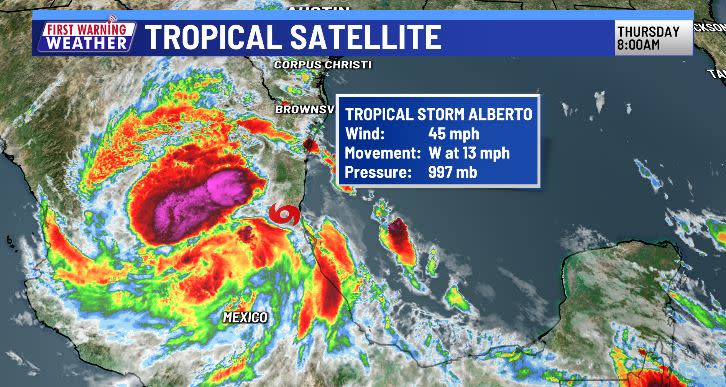
Tropical Storm Alberto

Tropical Storm Alberto shortly after landfall near Tampico, Mexico, on June 20, 2024.
  • June 19, 10 a.m.: Tropical Storm Alberto formed in the western Gulf of Mexico, about 185 miles east of Tampico, Mexico, or 295 miles south-southeast of Brownsville, Texas. Alberto had maximum sustained winds of 40 mph. The storm was moving west at 9 mph.

  • June 19, 10 p.m.: Tropical Storm Alberto reached its maximum intensity, with 50 mph winds.

  • June 20, 7 a.m.: Tropical Storm Alberto made landfall near Tampico, Mexico.

  • June 20, 10 a.m.: Tropical Storm Alberto was downgraded to a tropical depression with maximum sustained winds of 35 mph. The storm was located 95 miles west of Tampico, Mexico, moving west at 18 mph.

  • June 20, 4 p.m.: Tropical Depression Alberto dissipated about 260 miles west of Tampico, Mexico.

Copyright 2024 Nexstar Media, Inc. All rights reserved. This material may not be published, broadcast, rewritten, or redistributed.

For the latest news, weather, sports, and streaming video, head to KXAN Austin.