National Hurricane Center tracking disturbance. Will it become season's next tropical cyclone?
The tropics remained quiet early Friday morning, but by the afternoon, the National Hurricane Center was tracking a system in the central Atlantic showing potential for development as it approaches the Caribbean.
The "area of disturbed weather" currently has a low chance for development and is expected to approach the Lesser Antilles during the early to middle part of next week.
The National Hurricane Center is tracking three tropical waves in the Atlantic basin — which consists of the northern Atlantic Ocean, Caribbean Sea and Gulf of Mexico.
AccuWeather forecasters said earlier today the tropical wave that moved off the coast of Africa has a potential for development in August, although it faces a swath of dry air and Saharan dust. Both conditions make it difficult for tropical cyclones to develop and strengthen.
No tropical disturbances are expected to overcome those conditions over the next several days, according to the latest advisory from the National Hurricane Center.
When can we expect more tropical storms or hurricanes?
Activity is expected to pick up toward the end of July or first part of August as dry air, Saharan dust and wind shear diminish and ocean temperatures get even warmer.
"A lonesome tropical wave will be plowing westward through the dust this week; that system may be worth watching in the southwestern Atlantic or Gulf starting at end of next week, if anything is left of it after its trek," according to Dr. Ryan Truchelut, chief meteorologist at WeatherTiger. Truchelut works with the USA TODAY Network-Florida to provide the latest storm information Florida residents need.
Twisters meet hurricanes: The facts on tropical tornado threats | WeatherTiger
"We are approaching the point of the season (August) where we tend to see more of these systems take hold and organize into tropical depressions, storms, and even hurricanes under the right conditions," AccuWeather Lead Hurricane Expert Alex DaSilva said.
If that system is able to survive the hostile conditions as it continues westward, it may encounter more favorable conditions for tropical development near the Caribbean around the start of August," said AccuWeather Chief On-Air Meteorologist Bernie Rayno.
The tropical wave could be near the northern islands of the Caribbean, from the Leeward Islands to some of the Greater Antilles, in early August, according to AccuWeather.
Despite this period of quiet, forecasters are warning the 2024 Atlantic hurricane season is still expected to be extremely active and everyone should be prepared before a storm is on the horizon.
The peak of hurricane season runs from mid-August through mid-October. If your hurricane supplies are running low, or you haven't started an emergency kit, Florida's next sales tax holiday the end of August can help you save money.
National Hurricane Center: Don't focus only on the cone
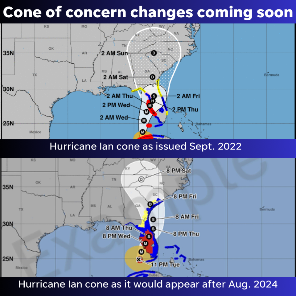
The National Hurricane Center's new experimental tropical cyclone forecast cone graphic will be coming out in mid-August, just in time for the peak period of hurricane season.
The new cone will add tropical storm and hurricane watches and warnings for interior counties in the path of the storm. The current cone displays watches and warnings only for coastal counties.
Watches and warnings for interior counties have been provided by local National Weather Service offices. The new graphic will combine tropical storm and hurricane watches and warnings into a single graphic.
"We hope it gets people to stop fixating on less reliable tools like the Saffir-Simpson Scale. There are more accurate ways to convey actual wind impacts in your community and at your home," said National Hurricane Center Deputy Director Jamie Rhome.
"The Saffir-Simpson Scale doesn't allow you to understand what the actual impact may be where you live. The Saffir-Simpson scale tells you peak wind (associated with a tropical storm or hurricane) but it may not be that over your community.
"A Category 5 hurricane over Vero Beach doesn't mean Category 5 winds everywhere in Vero Beach. That doesn't allow you to deduce impact or threats" where you live. "People misinterpret local impacts, with some overestimating the threat and some underestimating the threat."
"Explicit watches and warnings for high winds (in your county) allows you to prepare for tropical storms or hurricanes based on where you are."
The next storm of the season will be Debby.
Temperatures and forecast expected today across Florida
Pensacola: A 50 percent chance of showers and thunderstorms, mainly after 1 p.m. Mostly sunny, with a high near 88. Northeast wind around 5 mph becoming south in the afternoon. New rainfall amounts of less than a tenth of an inch, except higher amounts possible in thunderstorms.
Tallahassee: Showers and thunderstorms likely, mainly after 4 p.m. Mostly sunny, with a high near 93. Heat index values as high as 107. Calm wind. Chance of precipitation is 60%. New rainfall amounts of less than a tenth of an inch, except higher amounts possible in thunderstorms.
Jacksonville: Showers and thunderstorms, mainly after 3 p.m. High near 90. Heat index values as high as 103. Calm wind becoming southwest around 6 mph in the morning. Chance of precipitation is 80%. New rainfall amounts between a tenth and quarter of an inch, except higher amounts possible in thunderstorms.
Daytona Beach: 40 percent chance of showers and thunderstorms, mainly after 1 p.m. Mostly sunny, with a high near 89. Light and variable wind becoming east 5 to 10 mph in the morning.
Melbourne: A 20 percent chance of showers and thunderstorms after noon. Mostly sunny, with a high near 90. Heat index values as high as 103. South wind 5 to 10 mph becoming east southeast in the afternoon.
Port St. Lucie: A 30 percent chance of showers and thunderstorms, mainly between 2 p.m. and 3 p.m. Mostly sunny, with a high near 91. Heat index values as high as 102. Light southeast wind becoming east southeast 5 to 10 mph in the afternoon.
West Palm Beach: A slight chance of showers and thunderstorms before 2 p.m., then a slight chance of showers after 5 p.m. Mostly sunny, with a high near 87. Heat index values as high as 100. Southeast wind 7 to 13 mph. Chance of precipitation is 20%.
Naples: A slight chance of showers, then a chance of showers and thunderstorms after 2 p.m. Mostly sunny, with a high near 91. Heat index values as high as 105. East wind around 7 mph becoming southwest in the afternoon. Chance of precipitation is 30%.
Fort Myers: A 30 percent chance of showers and thunderstorms, mainly after 4 p.m. Sunny, with a high near 93. Heat index values as high as 105. Light and variable wind becoming east southeast around 6 mph in the morning.
Sarasota: A chance of showers and thunderstorms, then showers likely and possibly a thunderstorm after 3 p.m. Mostly sunny, with a high near 91. Heat index values as high as 110. East wind 6 to 9 mph becoming west southwest in the afternoon. Chance of precipitation is 60%. New rainfall amounts between a tenth and quarter of an inch, except higher amounts possible in thunderstorms.
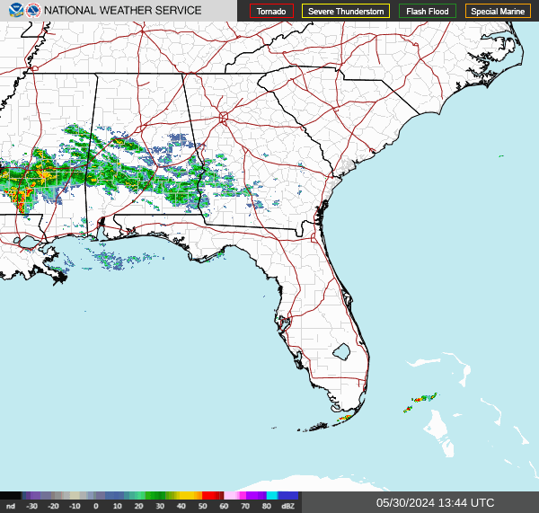
Florida weather radar: Track storms as they move across state
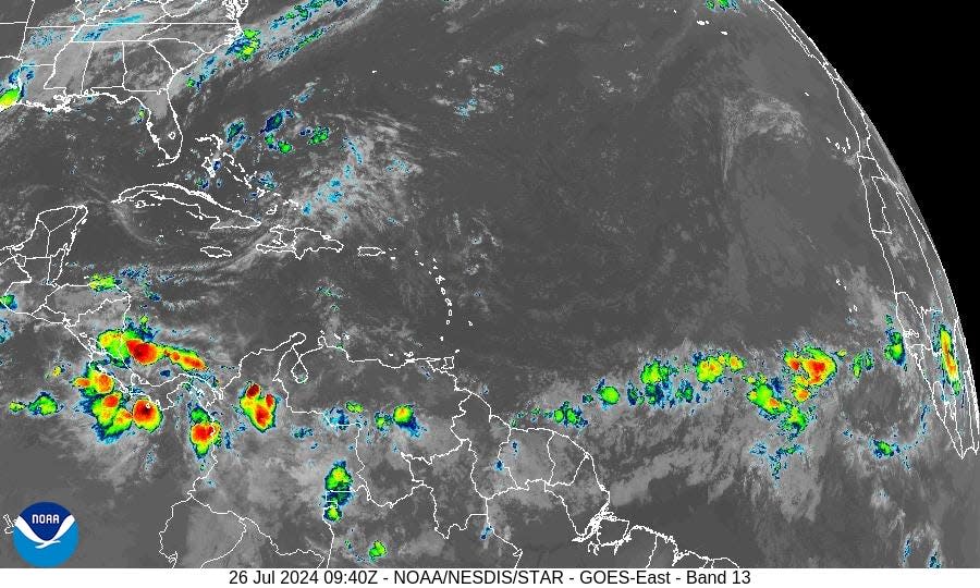
What is NOAA tracking in Atlantic basin?
Tropical disturbance: An area of disturbed weather over the central tropical Atlantic Ocean is expected to interact with an approaching tropical wave during the next several days.
Some development of this system will be possible while it approaches the Lesser Antilles during the early to middle part of next week and moves generally west-northwest near the Greater Antilles toward the latter part of the week.
Formation chance through 48 hours: low, near 0 percent.
Formation chance through 7 days: low, 20 percent.
What does the colored area on the NOAA map mean?
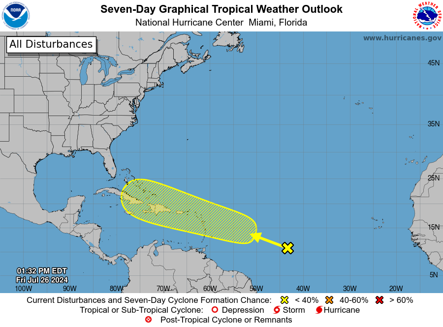
The hatched areas on tropical outlook maps indicate "areas where a tropical cyclone — which could be a tropical depression, tropical storm or hurricane — could develop," said National Hurricane Center Deputy Director Jamie Rhome.
The colors make it visibly clear how likely a system could develop, with yellow being a low chance, orange a medium chance and red a high chance.
The National Hurricane Center generally doesn't issue tropical advisories until a there is a named storm, but there is an exception.
"If a system is near land and there is potential for development, the National Hurricane Center won't wait before it issues advisories, even if the system hasn't become an actual storm. This gives residents time to prepare," Rhome said.
What else is NOAA tracking?
The National Hurricane Center is monitoring three tropical waves. Here's the latest update from the NHC as of 2 p.m. July 26:
Tropical wave 1: A tropical wave in the eastern Atlantic is moving west at 11 to 17 mph.
Tropical wave 2: Another tropical wave in the eastern Atlantic is also moving west at the same speed, 11 to 17 mph.
Tropical wave 3: A tropical wave in the central Caribbean is moving west at 17 to 23 mph.
Who is likely to be impacted?
It's too early to tell whether the disturbance moving across the central Atlantic will impact Florida or the U.S.
Forecasters urge all residents to continue monitoring the tropics and to always be prepared. That advice is particularly important for what is expected to be a very active hurricane season.
When is next Florida hurricane tax-free supplies holiday?
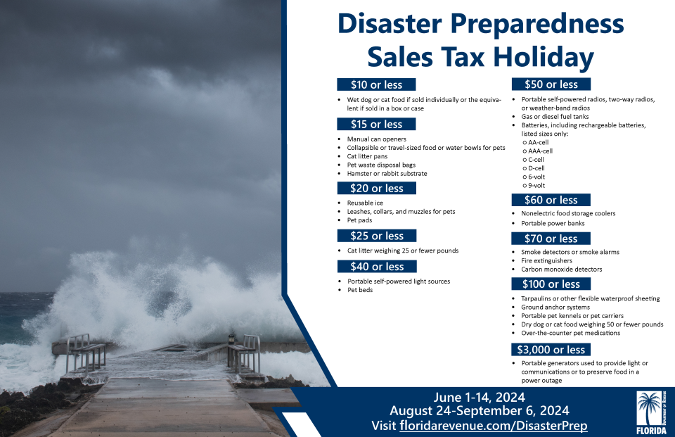
Save on hurricane supplies between Aug. 24 and Sept. 6. This will be the final tax-free holiday for 2024 when it comes to emergency supplies and it comes during the busiest period of the hurricane season.
Can't afford a generator or weeks of food? Here are the basics you should have on hand.
Eligible items included in the tax-free holiday include:
A portable generator used to provide light or communications or preserve food in the event of a power outage with a sales price of $3,000 or less.
A tarp or other flexible waterproof sheeting with a sales price of $100 or less.
An item normally sold as, or generally advertised as, a ground anchor system or tie-down kit with a sales price of $100 or less.
A smoke detector or smoke alarm with a sales price of $70 or less.
A fire extinguisher with a sales price of $70 or less.
A carbon monoxide detector with a sales price of $70 or less.
A nonelectric food storage cooler with a sales price of $60 or less.
A portable power bank with a sales price of $60 or less.
A gas or diesel fuel tank with a sales price of $50 or less.
A portable self-powered radio, two-way radio, or weather-band radio with a sales price of $50 or less.
A package of AA-cell, AAA-cell, C-cell, D-cell, 6-volt, or 9-volt batteries, excluding automobile and boat batteries, with a sales price of $50 or less.
A portable self-powered light source (powered by battery, solar, hand-crank, or gas) with a sales price of $40 or less, including: flashlights, lanterns and candles.
Eligible light sources and radios qualify for the exemption, even if electrical cords are included in the purchase.
Reusable ice (ice packs) with a sales price of $20 or less.
➤ See full list of items, including pet and cleaning supplies, exempt from sales tax
When is the Atlantic hurricane season?
The Atlantic hurricane season runs from June 1 through Nov. 30.
When is the peak of hurricane season?
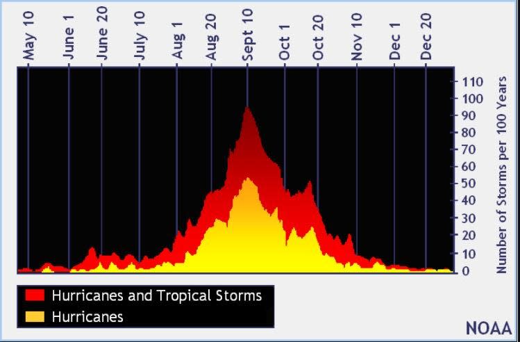
The peak of the season is Sept. 10, with the most activity happening between mid-August and mid-October, according to the Hurricane Center.
National Hurricane Center map: What are forecasters watching now?
Systems currently being monitored by the National Hurricane Center include:
Interactive map: Hurricanes, tropical storms that have passed near your city
Excessive rainfall forecast
What's next?
We will continue to update our tropical weather coverage daily. Download your local site's app to ensure you're always connected to the news. And look for our special subscription offers here.
This article originally appeared on Treasure Coast Newspapers: NHC tracking tropical disturbance. See possible impact, development

