We’ve never seen a storm like Beryl. What the Cat 5 hurricane says about a warmer future
Earliest Category 5 in the Atlantic. Earliest Category 4. Strongest June hurricane. Easternmost June hurricane. First system to undergo rapid intensification in the Atlantic in June. All fresh rewrites of a hurricane record book began in 1851.
Beryl, only the second named storm of 2024, is an eye-opening start to what forecasters had predicted could be one of the busiest — and scariest — hurricane seasons ever. The next few months are historically more active. And, for the second year in a row, the hurricane breeding grounds of the Atlantic Ocean, Caribbean Sea and Gulf of Mexico all contain the super fuel of hurricane engines — extremely hot ocean water.
For hurricane experts, Beryl’s historic rapid-fire development is both an extreme example of the sort of monster storms that can be produced under current climate conditions — and a signal of what may be more often in store if global and ocean warming trends continue.
“This is an outlier by any stretch,” said David Zierdan, Florida’s state climatologist. “And that doesn’t mean it’s the new normal, that it’s going to happen every year. But is climate change playing a role? I’m sure it is.”
Climate connection
Scientists are still sussing out all the complicated ways that climate change affects hurricanes and they stress that no one storm, even a record-breaker like Beryl, can be blamed on the ongoing climate shift alone. There have been even more powerful storms in the past, of course — just not so early in the season.
But they are most confident in a few specific changes already being observed in hurricanes: Higher sea levels lead to more storm surge and rain with hurricanes, hotter ocean water means storms have the opportunity to get stronger and warmer seas also increase the chances a storm will rapidly intensify.
And, right now, the Atlantic, and the Caribbean, are hotter than any other time in the record books for the second year in a row. Scientists say that’s likely due to a number of factors, including a volcanic explosion that shot water vapor into the atmosphere, weaker trade winds across the Atlantic and — bizarrely — a successful effort to reduce air pollution by ships crossing the Atlantic.
But the biggest slice of the pie, Zierdan said, is the well-documented impacts of climate change.
The other inputs are “very minor compared to the main culprit, which is greenhouse gases and the general warming of the planet,” he said.
READ MORE: What we know — and don’t — about how climate change impacts hurricanes
Whatever combination of factors were at work, Beryl met — and surpassed — the official benchmark for rapid intensification over the weekend when the hurricane gained 65 mph in sustained wind speeds in 24 hours.
It became the earliest storm on record to achieve that level of intensification, and in a spot in the Caribbean that doesn’t often see rapid intensification until far later in the season, said Kieran Bhatia, senior vice president at insurance broker Guy Carpenter and author of several academic papers on rapid intensification.
“Zero storms before Beryl achieved 65 mph of intensification before July. Forget about the location in the Atlantic, this is anywhere in the Atlantic,” he said. “It’s like redefining what is typical behavior. It’s really eye-opening.”
Animation of Hurricane Beryl's intensity evolution alongside storm-following GOES-East infrared satellite imagery from 18 UTC 28 June to 12 UTC 2 July.
The brief weakening period shown in this graphic was associated with an eyewall replacement cycle (ERC). pic.twitter.com/5DI5TCNzMb— Dr. Kim Wood (@DrKimWood) July 2, 2024
Bhatia’s research has found that rapid intensification has become more common for storms in the Atlantic basin, and climate change could be the reason why. Specifically, through water temperatures heated up by global warming.
“On average, a storm that forms in areas that have higher ocean heat content and sea surface temperatures has increased probability of intensification,” he said.
However, he noted, it’s very difficult to cross the line and say with certainty that climate change “caused” any one event. Not without running thousands of years of weather data in global computer models, he said.
That’s why scientists wait for the results of what’s known as climate attribution studies that do exactly that. So it may be some time before we have a scientific answer to the question of how climate change affected a powerful storm like Beryl.
“Would I say this is something that’s going to happen the rest of the year? I don’t know. The odds are increasing,” Bhatia said.
There are trends that argue increasing ocean temperatures are already influencing storm development. Ten of the 15 most active seasons for named storms, for instance, have occurred since 2000 — but so has the ability to spot and measure them with satellites and other technology. For major storms of Category 3 or above, the impact is not profound. Only 2005 ranked in the top eight years for major hurricane production, with 7 storms. The No. 1 years for major storms was 1950, with eight. Six other years tied with 6 major storms, all before 2000, including 1926.
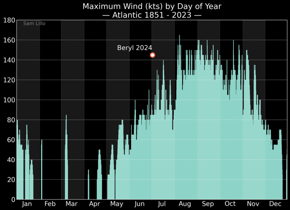
Beryl, the record-buster
Beryl certainly has been a storm for the books. Its explosion from tropical depression to Category 5 monster happened in just three days, far earlier in the season than meteorological records suggest it should have. It beat out Hurricane Emily, in 2005, for the top spot as earliest July hurricane on record by a solid two weeks.
It took only 48 hours to get from tropical depression to a Category 4 storm, a feat only three other storms have pulled off: Hurricane Keith in 2000, Hurricane Wilma in 2005 and Hurricane Delta in 2020.
Sam Lillo, a meteorologist tracking Beryl, said it was the earliest storm to speed run that transition. The other three storms didn’t do it until September and October, closer to the peak of the season.
“Beryl is doing this a full two months in advance of when these other extremes happened,” said Lillo, a senior software engineer at private forecast firm DTN Weather.
Beryl also joins a rare crowd of powerful storms that have hit the southern end of the east Caribbean, including Grenada and St. Vincent and the Grenadines. According to NOAA’s historical hurricane track database, the only other major storms on record to cross within 80 miles of the islands were Hurricane Ivan in 2004 and Hurricane Allen in 1980, both of which passed as Category 3 storms.
“Putting aside the time of year, this is already unique for its intensity in this area,” Lillo said.
Hurricane Beryl formed in a patch of ocean perfectly suited for strong storms. Besides the abnormally hot water, there was little storm shear around to topple the hurricane’s tall, straight core. And the Saharan Dust sweeping across the Atlantic, which normally sneaks hot, dry air into storms and slows them down, had formed a little eddy around the spot where Beryl formed, giving it a hot, moist home to grow with few interruptions.
“To reach or maintain Category 5 strength requires the perfect combination of factors. That’s what we’re seeing now,” Zierdan said.
Dust to the left, dust to the right, there in the middle, Beryl, a benchmark storm. pic.twitter.com/Pe2cOG641z
— Noah Bergren (@NbergWX) July 2, 2024
For those reasons, Zierdan and Lillo said, Beryl was an anomaly of a storm. Yet it wasn’t surprising to meteorologists watching the signs for this hurricane season. Lillo called Beryl “a highly-probable historic event.”
While a storm like Beryl needs multiple things in line to strengthen to the rare echelon of Category 5, experts said one of the most important ingredients in the mix is hot water. And there’s plenty of it in the Atlantic right now.
Water temperatures for the last month have been consistently running at levels usually seen in September, the peak of the season. And that’s not just sea surface temperatures, it’s the top 2,000 meters of the water as well, known as ocean heat content.

Hot water provides moisture for the hot, wet storm clouds hurricanes wrap around their core. The hotter the water, the more potential for very strong storms.
“It’s really the warm ocean temperatures that are running 2 or 3 degrees Fahrenheit above normal,” Lillo said. “That little bit is enough to make a huge difference in how strong a storm gets.”
Last year, forecasters said the main ingredients that made the hurricane season so active were the record-breaking water temperatures speeding things up, and a global weather phenomenon called El Niño that sparked up extra wind shear, somewhat slowing down storm action.
This year, El Niño is gone. And NOAA scientists said there’s a 65% chance it will replaced by the opposite phenomenon, La Niña, in the peak of hurricane season — July through September. La Niña is associated with low wind shear in the Atlantic, making it easier for storms to form and strengthen.
In 2023, Lillo said, storms mostly formed in the rare windows when wind shear lowered enough to allow storms to take advantage of all that hot water.
“This year we’re expecting those windows to be a lot larger and more frequent,” he said.

