Video shows a vortex of smoke amid wildfire. Was it a fire tornado?
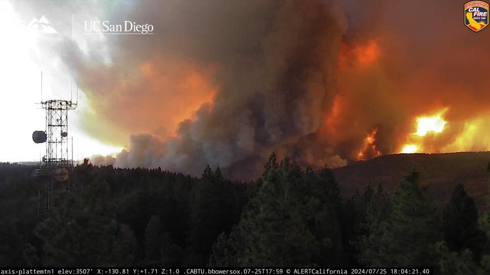
A whirling vortex of smoke seen on camera as the "Park Fire" in California exploded Thursday looked just like a tornado, but scientists are investigating whether it was a rare fire tornado or just a striking example of the extreme fire behavior they're seeing more often.
The massive rotating column moved past a remote live camera in the mountains northeast of Chico, California and quickly caught the attention of a cadre of weather and fire scientists on social media.
"Wildfire plumes rotate, especially with the ones that are growing quite rapidly and the ones that are very intense," said Nick Nauslar, fire weather science and operations officer for the Storm Prediction Center, based at the National Interagency Fire Center in Boise, Idaho. "However we don't always get the really strong rotation."
Saturday news: Park Fire quickly becomes one of the biggest wildfires in California history
The rotating pillar of smoke shown on the video is not the fire tornado, Nauslar said. In this case, scientists think a fire tornado could have been inside the swirling pillar, similar to the way regular tornadoes can be camouflaged by intense rainfall wrapped around them.
All the ingredients were there for a fire tornado, said Daniel Swain, a climate scientist with the UCLA Institute of the Environment and Sustainability.
In addition to the stunning video, scientists are looking at the radar and remote sensing data, which showed even stronger evidence for a possible fire tornado with strong winds, Swain said. Reports from nearby firefighters of "strong winds from different directions at the same time" are further evidence, he said. He called it a "strikingly clear indication of a potentially tornado-strength 'pyrovortex.'"
Mapping the Park Fire: California's largest wildfire has burned 307,368 acres in less than 3 days
A close look at the video shows a pair of rotating vortices, one rotating clockwise and the other rotating counterclockwise, and that's a behavior seen in strong updrafts or fire plumes in other fires that produced fire tornadoes, such as the Carr Fire in Northern California in 2018, Nauslar said.
Rotating columns also produce smaller rotating vortices out ahead of the plume, and those can be seen in the video, he said. The fire follows the heat and the plume moves with it.
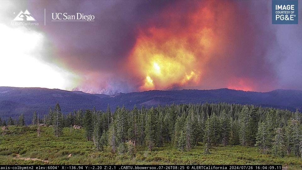
The intensity of the Park Fire has proven itself in the fire's shocking and rapid spread. Ignited on Wednesday afternoon, the fire had grown to more than 348,000 acres by Saturday morning. Coming in the midst of weeks of record-breaking temperatures, the fire is taking advantage of dried grasses and other vegetation and hilly terrain.
What is a fire tornado?
This can be confusing because several terms are used broadly and interchangeably by many to describe the whirling vortexes big and small that occur in and around wildfires.
The rare fire tornadoes studied by fire weather experts and meteorologists are large vortexes with strong winds generated when an intense wildfire's rotating plume of smoke interacts with the heat beneath it and the environment around it, Swain said.
The more technical term is fire-generated tornadic vortexes, but people also call them pyrotornadoes, Nauslar said.
Both Nauslar and Swain said the video depicts the classic fire behavior that generates thunderstorm-like clouds called pyrocumulonimbus clouds as plumes build into the atmosphere.
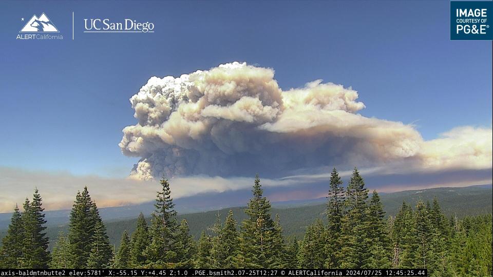
"When you think about a big fire plume, it can oftentimes grow to be a pyrocumulonimbus," Nauslar said, "essentially a fire thunderstorm, a deep convective cloud generated by intense large wildfires."
Scientists long have known that fires create their own weather because of the intense heat they generate.
Intense wildfires can reach temperatures of as high as 1,400 degrees, according to the Royal Meteorological Society in the United Kingdom.
What are fire whirls?
Fire whirls are small rotating tendrils of flames or smoke that occur along the edges of fires. Almost every firefighter has encountered these, Swain said. They could be 6 - 30 feet tall and last for a few seconds to maybe a minute.
"They look like tornadoes, but aren't. Even a house fire or a camp fire can produce little whirls," he said. They can still be problematic but not hugely consequential."
A fire tornado is like a supercharged fire whirl.
Have there been other fire tornadoes?
Yes.
The tornado in the Carr fire occurred almost six years ago to the day, and was one of the most extreme examples of a fire tornado, Swain said. The tornado's winds reached 143 mph winds, the equivalent of an EF-3 tornado on the five-level Enhanced Fujita Scale.
A fire tornado was confirmed in the Loyalton Fire in California in 2020.
A tornado was photographed inside a plume in Langdon, North Dakota on Oct. 24, 2011.
A fire tornado occurred during a devastating wildfire in Canberra, Australia in 2003.
Are fire tornadoes occurring more often?
Scientists aren't sure.
Part of the reason why these events seem to be occurring more often is because of the number of people walking around with cameras on their phones, Swain said.
The camera that caught Thursday's event is operated by the ALERTCalifornia network, affiliated with the Scripps Institution of Oceanography at the University of California. The network's proliferation of live cameras is giving researchers an unprecedented look at this summer's wildfire activity.
Because fire tornadoes are so rare, scientists don't have enough data to say how they've changed over time.
However, it's plausible they could be increasing, because several recent studies presented direct evidence that fires are intensifying, Swain said. "You do tend to see these exotic events during more intense fires."
“Large and potentially dangerous pyrocumulonimbus events are more common,” Swain said.
How could the fire tornado be confirmed?
Typically the National Weather Service confirms tornadoes through surveying wind damage. If there was damage in the path of the plume on Thursday that didn't get burned over by the fire, the weather service could confirm a fire tornado. So far, the weather service field office in Sacramento hasn't received any reports of wind damage on the active fire scene, said meteorologist Dakari Anderson.
It's possible some firefighters might have seen the fire tornado, but so far they've all been kind of busy, Swain said.
Even if no one confirms a fire tornado, that doesn't mean there wasn't one, Swain said. "It's kind of like a tree falling in the forest. If no one was there to see it happen, that doesn't mean it didn't happen."
Contributing: Elizabeth Weise, USA TODAY
Dinah Voyles Pulver covers climate change and the environment for USA TODAY. She's been writing about wildfires since the Florida firestorm of 1998. Reach her at dpulver@gannett.com or @dinahvp.
This article originally appeared on USA TODAY: Video shows possible fire tornado amid California wildfires

