Weather alert: Severe storms possible Friday with damaging winds and torrential rain
A cold front is expected to cross Ohio on Friday.
The passage of the front is expected to bring slightly cooler temperatures and a chance of rain.
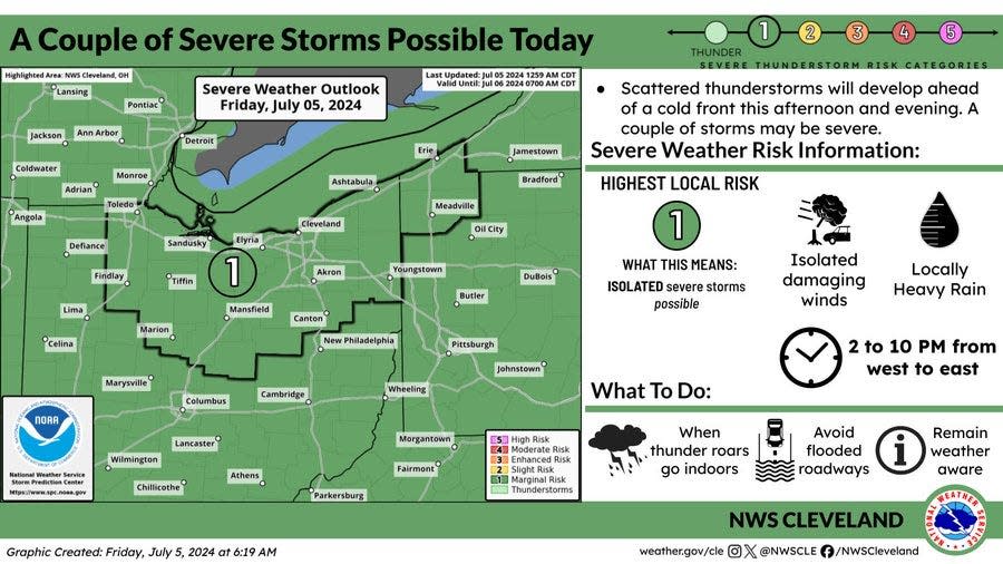
The National Weather Service says some of these isolated storms on Friday could be severe across northern Ohio.
"A couple storms could be strong to severe with the main hazard of damaging wind gusts," the weather service says.
When are the storms expected on Friday?
The weather service says the best chance for rain and severe storms across northern Ohio will be between 2 p.m. and 10 p.m. Friday.
The storms are expected to be scattered and will clear from west to east.
Things are expected to dry out on Saturday with a chance of showers returning after 2 p.m.
Will it get hot again?
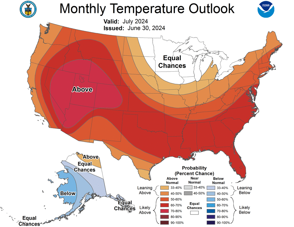
The weather service says the heat will return to northern Ohio by Monday.
Temperatures in the 90s are expected on Monday with highs in the upper 80s through Thursday.
The Climate Prediction Center says it is likely that northern Ohio will experience above average temperatures.
While it might be hot, the prediction center says average precipitation is expected in July.
Is northern Ohio still in a drought?
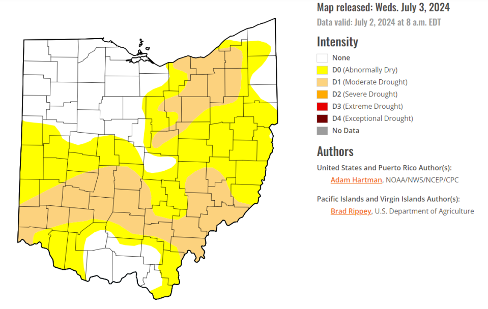
The Fourth of July rains across northern Ohio will help with the drought.
But things leading up to the fireworks in the sky were still pretty parched.
The latest assessment by the U.S. Drought Monitor says much of northern Ohio including Greater Akron is still considered to be in a moderate drought.
About 70% of Ohio is now under some type of drought conditions.
The lack of rainfall could mean some damage to crops and pastures.
It also increases the risk of fires along with drying up local ponds, streams and reservoirs.
What's the weather forecast?
Friday: A chance of showers and thunderstorms, mainly after 3 p.m. Increasing clouds, with a high near 86. Calm wind becoming southwest 5 to 7 mph in the afternoon. Chance of precipitation is 30%. New rainfall amounts of less than a tenth of an inch, except higher amounts possible in thunderstorms.
Friday night: A chance of showers and thunderstorms before 2 a.m., then a slight chance of showers between 2am and 3am. Mostly cloudy, with a low around 68. Southwest wind around 7 mph. Chance of precipitation is 50%. New rainfall amounts of less than a tenth of an inch, except higher amounts possible in thunderstorms.
Saturday: A slight chance of showers after 2 p.m. Mostly sunny, with a high near 82. Southwest wind 8 to 13 mph. Chance of precipitation is 20%.
Saturday night: Partly cloudy, with a low around 63. West wind 5 to 8 mph becoming calm after midnight.
Sunday: Sunny, with a high near 87. Calm wind becoming west around 6 mph in the afternoon.
Sunday night: Mostly clear, with a low around 64.
Monday: Sunny, with a high near 92.
Monday night: Partly cloudy, with a low around 69.
Tuesday: A chance of showers, then showers likely and possibly a thunderstorm after 2 p.m. Partly sunny, with a high near 87. Chance of precipitation is 60%.
Tuesday night: Showers likely and possibly a thunderstorm before 8 p.m., then a chance of showers and thunderstorms between 8 p.m. and 2 a.m. Mostly cloudy, with a low around 66. Chance of precipitation is 60%.
Wednesday: Mostly sunny, with a high near 84.
Wednesday night: Partly cloudy, with a low around 65.
Thursday: Mostly sunny, with a high near 85.
This article originally appeared on Akron Beacon Journal: Akron weather forecast calls for possible severe storms Friday

