Weather Permitting: Heat in Fayetteville shows no sign of stopping, but rain is on the way
If you went outside early this morning and were immediately immersed in "air you can chew," you weren't alone.
For the third time this week, Fayetteville either broke or tied the date's "high-low" temperature record — this time at 78 degrees. The city didn't hit 100 degrees, but both Simmons Air Field and Pope did. Clinton led the way with back-to-back heat index readings of 108, while Lumberton wasn't far behind at 106.
The heat will continue through the weekend. The good news is that the Cape Fear region will see its first opportunity for widespread rainfall in weeks.
Oh, and the Fourth of July outlook? No surprise — hot.
Here's the setup
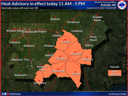
A heat advisory remains in place across the Cape Fear region. Temperatures this afternoon will actually be a bit less oppressive than Wednesday, but elevated dew points will make Fayetteville feel like 105 or so. It could be worse: Heat index readings should top 110 to the south.
It's another day to limit outdoor activity, especially for those with breathing problems. Pets need a cool place to rest, and everyone should be drinking water.
Finally, the region should see some rain later today. A developing front will push into North Carolina, sparking scattered, strong storms.
Fayetteville will still climb into the mid-90s, so any showers will make things steamy. Some storms ahead of the front sould group, forming squall lines in the later afternoon and early evening.
On Friday, a few showers may linger to the south, then slide north as the front returns. Rain chances are lower the further north you go, with highs of about 95 for Fayetteville. The best chance of rain is with late afternoon heat. Lows will again hold in the mid-70s.
The weekend
Hot and muggy with a chance of afternoon showers Saturday. The dew point will stay in the mid-70s, pushing the heat index both days into triple digits. Another heat advisory is likely on Sunday with highs of about 97 and a heat index above 105.
More: Looking for Fourth of July events? Here's what's happening in the Fayetteville area
Later on Sunday, the best chance for widespread rain should develop ahead of another front. Totals won't break the drought, but after weeks of grass crunching and corn fading, any solid rainfall will be welcome. Best chances for heavier totals will be east and south of I-95.
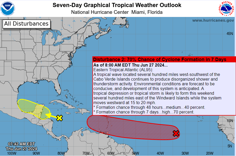
In the tropics
Activity deep in the Gulf should be of interest to Mexico and southern Texas. The Carolinas can watch a string of disturbances blossoming off the African coast. It's early for such activity, and conditions in the Central Atlantic are hostile currently. Development is expected but will take several days. Stay tuned!
Got a weather question? Chick Jacobs can be reached at ncweatherhound@gmail.com or NCWeatherhound on X/Twitter.
This article originally appeared on The Fayetteville Observer: Weekend weather forecast for Fayetteville

