A month's worth of rain could hit the Los Angeles area over 2 days, AccuWeather forecasts
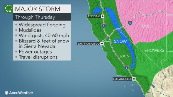
Following one round of rain and mountain snow on Tuesday, an even larger storm system will further raise the risk of flooding, mudslides and avalanches from through Thursday.
Los Angeles received over 1.75 inches of rain on Monday and Tuesday, and San Diego picked up just over 0.55 of an inch of rain.
AccuWeather meteorologists are forecasting that the Los Angeles basin could receive 2-4 more inches of rain beginning Wednesday night and lasting into Thursday night. This would bring the rainfall total for the week to 5 or more inches. The average rainfall for downtown L.A. during the entire month of January is 3.12 inches. Nearly that much rain fell through Jan. 15.
Areas north of L.A. could get 4 to 8 inches of rain, while less populated areas around Paradise - hard hit by the wildfires - could receive more than 8 inches of rain.
#Encino; Debris flow into a home causing significant damage. 14 additional homes under evacuation warning. Fortunately, no injury. Continual assessment of hillside taking place due to increased #LARain expected. #LAFD #LADBS #LAPD pic.twitter.com/9pIi1NH0Wt
— Erik Scott (@PIOErikScott) January 15, 2019
"San Diego will likely receive between 1 and 3 inches of rain by week's end," said AccuWeather Meteorologist Brian Thompson. "The city averages 1.98 inches for the entire month of January."
"Burn-scar areas will be most susceptible to devastating debris flows, and residents living in these areas should heed all evacuation orders by officials. Flooding and mudslides may not be limited to these communities," AccuWeather Senior Meteorologist Kristina Pydynowski said.
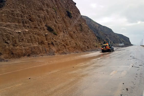
A skiploader clearing a river of mud that has flowed onto Pacific Coast Highway in Malibu, Calif., Monday, Jan. 14, 2019. (CalTrans via AP)
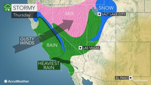
Central and Northern California will face major impacts from the last storm of the week as well with 1-4 inches of rain likely around the San Francisco Bay Area.
"That storm has the potential to drop several more inches of rain in the foothills east of the Sacramento Valley," Thompson said. "That includes the area devastated by the Camp Fire, which will enhance the risk for flooding and mudslides."
In addition, wind gusts of 40-60 mph will batter the Sacramento Valley and coastal areas from Santa Barbara to the Monterrey Peninsula and Northern California.
With how saturated the soil will become, it will take less wind than usual to down trees and power lines and trigger power outages. Residents should have a flashlight and backup generator on hand this week as the slew of storms pounds the state.
Motorists traveling along the I-5 corridor should be prepared for travel disruptions, delays and dangerous crosswinds this week, making sure never to travel through flooded roadways.
Excessive rainfall is predicted over western foothills of the Sierra Nevada and the northern Coast ranges, as well as the south- and southwest-facing slopes of the mountains surrounding Los Angeles and Santa Barbara.
In areas hit by the heaviest downpours, there can be an AccuWeather Local StormMax™ of 15 inches for the week.
The storm may also generate a couple of waterspouts and brief tornadoes along the California coast.
With several inches of additional rainfall expected and many more feet of snow on tap across the Sierra Nevada Wednesday afternoon through Thursday, the threat of flooding, mudslides and avalanches will continue to ramp up through the end of the week.
Major winter storm approaches California
AP Photo/Garret Fischer


First, at vero eos et accusamus et iusto odio dignissimos ducimus qui blanditiis praesentium et accusamus et iusto odio dignissimos ducimus qui voluptatum.


(KGET-TV via AP)
In this photo provided by KGET-TV, a line of big rigs are stalled on Interstate 5 where it has been closed due to snow at Tejon Pass, an area known as the Grapevine, at Gorman in the Tehachapi Mountains of Southern California Monday, Jan. 14, 2019.

(Twitter/vnesscp)
Interstate 5 at Grapevine in California.

(Twitter/Deemo55)
Stuck on Interstate 5 at Grapevine in California.

(Twitter/vnesscp)
Interstate 5 at Grapevine in California.

(CalTrans via AP)
This photo provided by the California Department of Transportation (CalTrans) shows a skiploader clearing a river of mud that has flowed onto Pacific Coast Highway in Malibu, Calif., Monday, Jan. 14, 2019.

(Twitter/CaltransDist7)
All lanes were close in both directions on Interstate 5 in the Gorman and Lebec area due to heavy snow, accidents and vehicles stopped.

(CalTrans via AP)
This photo provided by the California Department of Transportation shows traffic stopped on Interstate 5 where it has been closed due to snow at Tejon Pass, an area known as the Grapevine, at Gorman in the Tehachapi Mountains of Southern California, Monday, Jan. 14, 2019.

(Twitter/Deemo55)
Stuck on Interstate 5 at Grapevine in California.
As much as 3 or 4 feet of additional snow will bury Interstate-80's Donner Summit through Thursday night, making chains and traction devices necessary for those without four-wheel drive. Motorists should be prepared for potential restrictions and closures.
"Over the high country of the Sierra Nevada, the latest train of storms may have deposited 7-8 feet of snow by Thursday night," according to AccuWeather Senior Meteorologist Alex Sosnowski.
Perhaps similar to what happened over the Grapevine on Monday afternoon, another quick burst of snow may visit Tejon Pass with the storm into early Thursday.
While the heavy snow will be a boon for ski resorts, the howling winds accompanying it will make skiing and hiking extremely difficult or even impossible.
The gusty winds during and milder air after the storm can also lead to a heightened risk of avalanches in the mountains. Skiers and hikers should heed avalanche watches and warnings and make sure not to venture out without a companion.
Download the free AccuWeather app to see how much rain or snow is expected in your community this week.
An area of high pressure will build into the state behind the system, allowing drier and milder conditions to return from Friday into the weekend.
One last storm may move through Northern California later Sunday into Sunday night before an extended period of dry and warm weather begins early next week and potentially lasts through the end of January.

TradeWx provides access to the CX weather market to allow you to trade the results of different weather events. Learn more on TradeWx.com.

