Development possible off Florida coast this weekend, NHC says
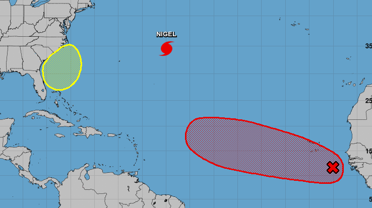
TAMPA, Fla. (WFLA) — The National Hurricane Center is tracking Hurricane Nigel and two disturbances, including one that is likely to form off Florida’s coast this weekend.
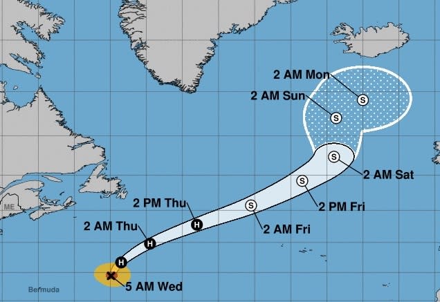
The NHC said Hurricane Nigel is holding steady as a Category 2 storm.
Nigel’s winds are near 100 mph, with higher gusts. The storm has likely reached its peak intensity and is expected to start gradually weakening late Wednesday.
Bear that prompted closures at Disney’s Magic Kingdom relocated, video shows
Meteorologists said the storm is forecast to become a post-tropical cyclone by Friday.
Nigel is located about 590 miles east-northeast of Bermuda and moving north at 16 mph. Swells from Nigel will affect Bermuda over the next few days and are likely to cause life-threatening surf and rip current conditions.
“We still have quite a bit of available ocean energy out there especially close to home,” WFLA Meteorologist Amanda Holly said. “As we go into October, yes, we typically see a decline in tropical activity but we have a lot of available ocean energy for any of those storms that do form.”
The NHC is also monitoring a tropical wave that is located just off Africa’s West Coast.
A tropical depression is likely to form late this week or this weekend while the system moves westward across the eastern and tropical Atlantic, the NHC said.
It has a 70 percent chance of development over the next seven days.
“Most of the longer range forecast models have this curving out, but there have been a few outliers that do bring it a little closer to home,” Holly said. “If it were going to impact the United States, yes, it would be in that 10-14 day timeframe,” she added. “We will have to watch a few more days to tell where this one is going to go.”
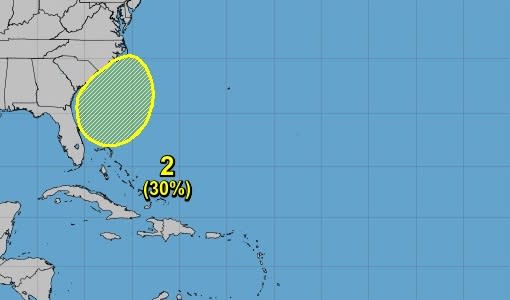
Lastly, the NHC is also monitoring a non-tropical area of low pressure expected to form east of the Florida peninsula late this week.
Forecasters said the system could acquire some subtropical characteristics this weekend as it moves northward.
“Regardless of development, this low is likely to bring gusty winds, heavy rain, and high surf to portions of the Southeast and Mid-Atlantic United States late this week and into this weekend,” the NHC said.
The system has a 30 percent chance of development over the next seven days.
“What’s coming from Florida is probably not going to get a name, probably not going to be a tropical system that we can show you a cone for, but it’s going to bring some messy weather,” WNCN Chief Meteorologist Wes Hohenstein said.
“Coming into this season, we were all excited because of upper-level wind shear and El Nino and now we’ve had 10 named storms in the last month, we’ve lived through the hottest summer on record,” he added. “All of these historical moments we’re passing because of hot temperatures and we’re seeing how that’s kind of feeding the tropical season beast.”
“What we’ve seen in the past 2.5 decades — we just hope we’re in an active cycle, and that at some point, the cycle will end,” WFLA Chief Meteorologist Jeff Berardelli said. “But I tend to have my doubts that we’re in any cycle at all. I think that as long as we continue to see warm water temperatures, we’re going to continue to see this play out in the Atlantic Ocean.”
For the latest news, weather, sports, and streaming video, head to WKRN News 2.

