National Hurricane Center tracking Hurricanes Lee, Margot. See who could be impacted
The National Hurricane Center is tracking two hurricanes and a system expected to become the season's next tropical depression, according to the latest advisory.
Hurricane Lee lost a little strength overnight, with maximum sustained winds dropping to 115 mph. As of 11 a.m., it is maintaining its strength as a Category 3 storm.
Farther east in the Atlantic, Margot has strengthened into a hurricane.
Highlights from 11 a.m. advisory
Hurricane Lee remains a large and powerful hurricane.
Tropical storm watch has been issued for Bermuda.
Dangerous surf and life-threatening rip currents will affect most of the U.S. east coast through much of the week.
It is still too early to know if any leftward bend will occur as Lee approaches North America.
Lee is huge, with hurricane-force winds extending 90 miles from the center, and tropical-storm-force winds 205 miles from the center. That will bring impacts well away from the eye.
Cooler waters churned up by Hurricanes Franklin and Idalia is expected to weaken Lee in 4-5 days.
Lee holds the title of the strongest hurricane to churn in the Atlantic during the 2023 season. Winds hit 165 mph Friday morning. Just 24 hours earlier, Lee was a Category 1 hurricane with 80 mph winds before it underwent rapid intensification.
Rapid intensification occurs when a tropical system's sustained winds increase by 35 mph or more in 24 hours. Lee more than doubled down that criteria, which is extremely rare, according to AccuWeather.
Here's the latest update from the NHC as of 2 p.m.:
Forecast path: Where is Hurricane Lee going?
AccuWeather meteorologists expect a high risk to lives and property from damaging winds and flooding in Nova Scotia this weekend as New England faces some direct impacts from Hurricane Lee.
Hurricane Lee projected path: Lee expected to bring big surf, dangerous currents to US East Coast
"Landfall is most likely in Nova Scotia, Canada, this weekend, but any waver in the track caused by non-tropical weather systems such as the high pressure to the east and the approaching jet stream could pull the hurricane westward toward New England or push it farther east toward Newfoundland and Labrador," said AccuWeather Chief On-Air Meteorologist Bernie Rayno.
How could Hurricane Lee impact Florida?
Hurricane Lee is expected to produce widespread heavy surf and rip currents along the entire U.S. East Coast this week, according to Dr. Ryan Truchelut, chief meteorologist at WeatherTiger.
"With gales already covering an extent of open ocean greater than the distance between Jacksonville and Miami, be grateful Lee will pass over 700 miles east of Florida.
"This massive windfield will expand further even as maximum winds decline, and that will drive heavy surf, rip current, and beach erosion impacts along the Florida East Coast north of Palm Beach between today and Sunday," Truchelut said.
AccuWeather meteorologists sounded the all-clear for landfall by Lee from Florida to North Carolina late last week.
On Tuesday, forecasters expanded that all-clear to include areas as far to the north as Delaware.
However, these same areas will experience frequent and strong rip currents that could be life-threatening. Rough surf will lead to beach erosion.
Florida impact: Hurricane Lee could cause Florida erosion, follow FSU football to Boston | Forecast
Sea and surf conditions will become even more dangerous from mid week into early this weekend, according to the National Weather Service Melbourne.
A high risk of deadly rip currents will continue at the beaches, while building swells from distant Hurricane Lee produce large breaking waves of 5 to 7 feet from Wednesday afternoon through late Friday or Saturday.
Minor beach and dune erosion will be possible during several high tide cycles Thursday through Friday.
Small craft operation over the local Atlantic will become increasingly dangerous, especially over the open waters well offshore and near inlets.
Coastal flooding at times of high tide is likely along portions of North Carolina's Outer Banks and southeastern Virginia this week, with a peak possible Friday, according to AccuWeather.
The severity of conditions from eastern New England to Nova Scotia and the island of Newfoundland in terms of wind, rain, and coastal problems will depend on the exact track and strength of Lee late this week and this weekend.
As Lee moves over cooler waters it will lose some wind intensity, Rayno said. However, as this happens, the storm's rain and winds will tend to spread out.
Some risk from direct impacts from Hurricane Lee extends as far to the west as Rhode Island and includes all of eastern Massachusetts, southeastern New Hampshire, and central and coastal Maine.
How to escape rip current: Graphics show how rip currents endanger swimmers
Hurricane Lee: Forecast path and how strong is it?
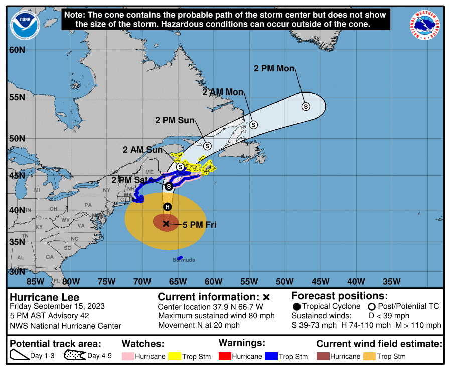
Special note on the NHC cone: The forecast track shows the most likely path of the center of the storm. It does not illustrate the full width of the storm or its impacts, and the center of the storm is likely to travel outside the cone up to 33% of the time.
Location: 555 miles south of Bermuda; 897 miles east of West Palm Beach
Maximum wind speed: 115 mph
Direction: west-northwest at 6 mph
At 11 a.m., the center of Hurricane Lee was located 555 miles south of Bermuda or near latitude 24.3 North, longitude 65.9 West.
Lee is moving toward the west-northwest near 6 mph. A slow west-northwest to northwest motion is expected during the next day or two, followed by a turn toward the north by midweek. On the forecast track, Lee is expected to pass near but to the west of Bermuda in a few days.
NOAA Hurricane Hunter data indicate that the maximum sustained winds remain near 115 mph, with higher gusts. Lee is a category 3 hurricane on the Saffir-Simpson Hurricane Wind Scale.Some slow weakening is forecast during the next 48 hours, but Lee is expected to remain a large and powerful hurricane.
Hurricane-force winds extend outward up to 90 miles from the center and tropical-storm-force winds extend outward up to 205 miles.
The estimated minimum central pressure is 951 mb based on dropsonde data.
How large is Hurricane Lee?
Hurricane-force winds extend outward up to 90 miles from the center and tropical-storm-force winds extend outward up to 205 miles.
If the center of Hurricane Lee was over Washington, D.C., and the storm was pretty much circular, tropical-storm-force winds would be felt as far north as New York City; to Pittsburgh, Pennsylvania; Roanoke, Virginia; and Kitty Hawk, North Carolina.
Wind fields are fluid and can shift and move depending on what's happening within the storm and how close it is to land, where there's greater friction than over the water.
Calculating wind speeds is complicated, since hurricanes aren't exactly circular. The distance hurricane and tropical-storm-force winds extend out from the center varies in each quadrant. The estimated diameter of Lee's hurricane force winds this morning is 143.75 miles and the diameter of tropical-storm-force winds is 374 miles.
Estimating wind fields: 'Every hurricane is different': Why experts are still estimating Idalia's impact
Hurricane Lee maximum sustained winds forecast
Prediction and timing of winds:
12 hours: 115 mph
24 hours: 115 mph
36 hours: 110 mph
48 hours: 105 mph
60 hours: 100 mph
72 hours: 90 mph
96 hours: 75 mph
120 hours: 50 mph
A Category 5 hurricane has maximum sustained winds of at least 157 mph.
Spaghetti models for Hurricane Lee
Special note about spaghetti models: Illustrations include an array of forecast tools and models, and not all are created equal. The hurricane center uses only the top four or five highest performing models to help make its forecasts.
Hurricane Margot strengthening

Location: 890 miles southwest of the Azores
Maximum sustained winds: 85 mph
Movement: north at 12 mph
At 11 a.m, the center of Hurricane Margot was located 890 miles southwest of the Azores or near latitude 30.2 North, longitude 39.4 West.
Margot is moving toward the north near 12 mph. A turn toward the north-northwest at a slower forward speed is expected beginning tomorrow, followed by a turn back generally toward the north at an even slower speed on Thursday and Friday.
Maximum sustained winds are near 85 mph, with higher gusts. Little change in strength is expected for the next several days, but short term flucuations, up or down, are possible.
Hurricane-force winds extend outward up to 35 miles from the center and tropical-storm-force winds extend outward up to 255 miles.
The estimated minimum central pressure is 975 mb.
Spaghetti models for Hurricane Margot
What else is out there and how likely are they to strengthen?

A broad area of low pressure over the eastern tropical Atlantic continues to produce disorganized showers and thunderstorms. This system is expected to consolidate, with a low on the western sidebecoming dominant over the next day or two.
Gradual development of the low is expected after that, and a tropical depression is likely to form by this weekend while the system moves west-northwestward or northwestward at about 15 mph across the central tropical Atlantic.
Formation chance through 48 hours: near 20 percent.
Formation chance through seven days: high, 80 percent.
Who is likely to be impacted?
Hurricane Margot poses no threat to land.
It's too early at this time to determine if there will be any impact to the U.S. from the tropical wave.
Forecasters urge all residents to continue monitoring the tropics and to always be prepared.
Weather watches and warnings issued in Florida
When is the Atlantic hurricane season?
The Atlantic hurricane season runs from June 1 through Nov. 30.
When is the peak of hurricane season?
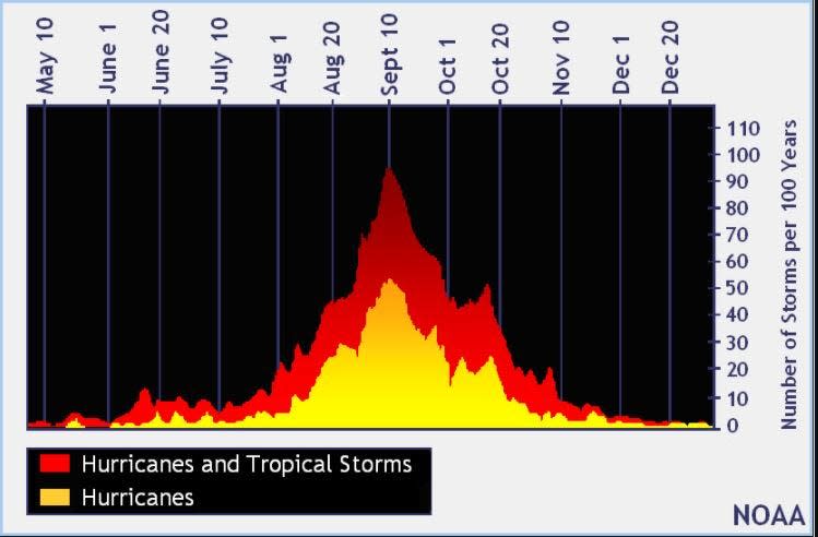
The peak of the season is Sept. 10, with the most activity happening between mid-August and mid-October, according to the Hurricane Center.
Tropical forecast over the next seven days
Excessive rainfall forecast
What's out there?
Systems currently being monitored by the National Hurricane Center.

Noaa
Embedded content: https://www.nhc.noaa.gov/xgtwo/two_atl_0d0.png?052051
What's next?
We will continue to update our tropical weather coverage daily. Download your local site's app to ensure you're always connected to the news. And look at our special subscription offers here.
This article originally appeared on Treasure Coast Newspapers: NHC tracking Hurricanes Lee, Margot. Spaghetti models, forecast path
