Tropical Storm Franklin could become Category 2 hurricane. See latest spaghetti models
The latest forecast predicts Tropical Storm Franklin will become a strong Category 2 storm with 105-mph winds by Sunday, according to the latest advisory from the National Hurricane Center.
Tropical Storm Franklin made landfall about 7:30 a.m. today along the southern coast of the Dominican Republic near Barahona.
By 2 p.m., the tropical storm was moving over the mountainous terrain of the Dominican Republic.
Franklin is bringing very heavy rain and "potentially life-threatening flash flooding" over Hispaniola as it moves from the Caribbean Sea into the Atlantic.
Winds are expected to reach hurricane strength by Saturday morning and continue to strengthen, reaching, 105 mph by Sunday, making Franklin a strong Category 2 storm but still below major hurricane strength. A major hurricane is one that has maximum sustained winds of at least 111 mph.
As the sun rises this morning, @NOAA's #GOESEast 🛰️ is monitoring Tropical Storm #Franklin as it makes landfall. This GeoColor imagery also shows frequent lightning within the storm.
Latest: https://t.co/ScLdyBac9D https://t.co/aB4JwfmrYw pic.twitter.com/sFq2lNrTKk— NOAA Satellites (@NOAASatellites) August 23, 2023
Tropical Depression Harold is weakening but was bringing heavy rain to portions of Texas and northern Mexico early Wednesday. Harold made landfall as a tropical storm at Padre Island, Texas, about 11 a.m. Aug. 22.
Elsewhere in the Atlantic basin, forecasters are tracking two other disturbances.
Invest 92L in the eastern Atlantic has a low chance for tropical cyclone development.
In the central Atlantic, Invest 7, which is the remnant of what was Tropical Storm Emily, is likely to regenerate into a tropical depression or tropical storm late this week or this weekend
Florida and August hurricanes: As the tropics boil, a cautiously optimistic August hurricane forecast for Florida
Will Florida get a hurricane?
All current models keep Tropical Storm Franklin well east of Florida.
"Franklin poses no direct threat to Florida," said the Florida Division of Emergency Management.
While Franklin is expected to become a Category 1 hurricane over the weekend, "the track and intensity remain uncertain afterwards, no direct impacts are expected along the U.S. East Coast," said the Florida Public Radio Emergency Network.
How quickly Franklin strengthens will determine its exact path, which remains uncertain since it's poorly organized, according to AccuWeather.
One possibility is that Franklin could turn toward the northwest and wander within a few hundred miles of Bermuda this weekend.
Here's the latest update from the NHC as of 2 p.m.:
Tropical Storm Franklin could become Category 2 hurricane

Location: 40 miles south of Puerto Plata, Dominican Republic; 160 miles south of Grand Turk Island; 788 miles southeast of West Palm Beach
Latitude/longitude: near latitude 19.2 North, longitude 70.7 West
Maximum wind speed: 40 mph
Direction: north-northeast at 13 mph
On the forecast track, the center of Franklin will move off the north coast of the Dominican Republic later this afternoon and then move over the southwestern Atlantic into the weekend.
Maximum sustained winds remain near 40 mph, with higher gusts. Little change in strength is expected through tonight, but gradual strengthening could begin by Thursday.
Franklin is expected to become a hurricane Saturday over the southwestern Atlantic by Saturday, with winds reaching 105 mph by Sunday, making it a strong Category 2 hurricane.
The estimated minimum central pressure is 1004 mb.
Franklin is expected to bring 6 to 12 inches of rain to Hispaniola. Some areas across the central portion of the island could see 16 inches.
Spaghetti models for Tropical Storm Franklin
Tropical Depression Harold continues to weaken
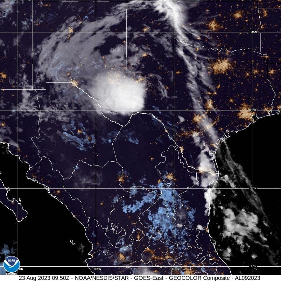
Location: 235 miles south of Midland, Texas
Latitude/longitude: 28.6N 102.1W
Maximum sustained winds: 30 mph
Movement: west-northwest at 14 mph
At 5 a.m., Tropical Depression Harold was moving west-northwest at 14 mph and expected to pick up speed into Thursday morning.
Harold is expected to dissipate as a tropical cyclone as its surface center devolves while tracking across far northern Mexico.
Harold is expected to bring 1 to 2 inches of rain across the Big Bend and Trans Pecos regions of Texas as well as southern New Mexico through tonight. Some areas could receive 4 inches. Isolated to widely scattered instances of flash flooding are possible.
No further public advisories will be issued by the National Hurricane Center.
What else is out there and how likely are they to strengthen?

Invest 7: An area of low pressure more than 1,000 miles miles northeast of the Leeward Islands (the remnants of former Tropical Storm Emily) continues to produce a large area of disorganized showers and thunderstorms northeast of its center.
Upper-level winds are forecast to become more conducive for development by tomorrow, and this system is likely to regenerate into a tropical depression or tropical storm late this week or this weekend when the system moves northward over the subtropical central Atlantic.
➤ Spaghetti models for former Tropical Storm Emily
Formation chance through 48 hours: medium, 60 percent.
Formation chance through 7 days: high, 70 percent.

Invest 92L: Disorganized showers and thunderstorms continue in association with an area of low pressure located several hundred miles west of the Cabo Verde Islands.
Environmental conditions appear only marginally favorable for some slow development through early next week while the system moves west-northwestward to northwestward into the central tropical Atlantic.
➤ Spaghetti models for Invest 92L
Formation chance through 48 hours: low, 10 percent.
Formation chance through 7 days: low, 30 percent.
Weather watches and warnings issued in Florida
When is the Atlantic hurricane season?
The Atlantic hurricane season runs from June 1 through Nov. 30.
When is the peak of hurricane season?
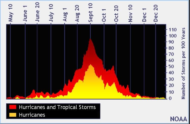
The peak of the season is Sept. 10, with the most activity happening between mid-August and mid-October, according to the Hurricane Center.
Tropical forecast over the next seven days
Excessive rainfall forecast
What's out there?
Systems currently being monitored by the National Hurricane Center.

What's next?
We will continue to update our tropical weather coverage daily. Download your local site's app to ensure you're always connected to the news. And look at our special subscription offers here.
This article originally appeared on Treasure Coast Newspapers: NHC tracking Tropical Storm Franklin, Harold, 2 tropical waves. Impact

