Tropical Storm Harold makes landfall. See spaghetti models for Tropical Storm Franklin
Tropical Storm Harold formed early this morning in the Gulf of Mexico and moved quickly west, making landfall at 11 a.m. on Padre Island, Texas, according to the latest advisory from the National Hurricane Center.
Heavy rains and tropical-storm-force winds are expected in the area over the next several hours and several tornado warnings have been issued as the storm moves farther inland.
Harold is the latest addition to a string of tropical systems being tracked by the National Hurricane Center.
Tropical Storm Franklin is drifting in the Caribbean Sea and expected to strengthen before reaching Hispaniola. Forecasters are predicting "significant and potentially life-threatening flash flooding" over the island through Wednesday.
Forecasters are predicting Franklin will be a strong tropical storm Saturday and become a hurricane Sunday with 80 mph winds, making it a Category 1 storm.
What was Tropical Storm Gert weakened into a tropical depression early Tuesday and became a post-tropical cyclone by 11 a.m.
Farther east in the Atlantic, what was Tropical Storm Emily may restrengthen as it moves north.
Another disturbance west of Cabo Verde — Invest 92L — has a medium chance of becoming a tropical depression later this week.
The next named storms of the Atlantic hurricane season will be Idalia and Jose.
Tropical Storm Harold path: Live updates as Harold targets Texas
Hilary live updates: 'Unlike anything our community has faced': Hilary triggers floods, rescues
'Above-normal hurricane activity' expected last half of August
Colorado State University forecasters are predicting above-normal hurricane activity over the next two weeks, according to their latest two-week forecast issued Aug. 17.
The last half of August "typically marks the real ramp-up for Atlantic TC (tropical cyclone) activity. The primary threat formation area for major hurricanes in late August is in the eastern and central tropical Atlantic," CSU said.
Is Florida getting a hurricane?
While Tropical Storm Franklin is expected to strengthen into a hurricane sometime during the week, the system "poses no threat to Florida over the next five to seven days, at least," according to the Florida Division of Emergency Management.
Franklin is expected to turn north later today. After moving into the Atlantic, Franklin should turn toward the northeast but conditions later in the week could allow the storm to start moving north again.
Costly natural disasters: Florida ranks high on these lists of most affected by natural disasters, climate change
While conditions in the tropics do look quite busy, "no direct effects are expected at the moment from the systems out there," said John Pendergrast, meteorologist with the National Weather Service Melbourne.
Swells along the east central Florida coast are possible as the week progresses, Pendergrast added.
"Tropical Storm Franklin doesn't look to have much impact to South Florida or Florida in general, although it may bring an enhanced risk for rip currents," said Robert Garcia, senior meteorologist with the National Weather Service, Miami.
"Franklin's impact depends on the movement it takes and how strong it is. The Bahamas will disrupt some of its energy. If it survives north of the islands into the open Atlantic, there is some potential for more swells" along beaches. "It's too early to tell yet."
"We're heading into the peak of the season," Garcia said. "Be prepared and watch the forecasts."
Here's the latest update from the NHC as of 2 p.m.:
Tropical Storm Franklin expected to become hurricane

Location: 230 miles south-southwest of Santo Domingo, Dominican Republic; 953 miles southeast of West Palm Beach.
Maximum wind speed: 50 mph
Direction: northwest at 7 mph
Maximum sustained winds for Tropical Storm Franklin are near 50 mph, with higher gusts. Winds are forecast to reach 70 mph Saturday and 80 mph by Sunday, making Franklin a Category 1 hurricane.
Satellite images indicate a new center may be forming farther west, and a NOAA Hurricane Hunter aircraft is current investigating Franklin's wind field to determine if that is the case.
Maximum sustained winds are near 50 mph, with higher gusts. Little change in strength is forecast before Franklin reaches Hispaniola. Some weakening is likely while the storm moves acrossHispaniola.
A turn toward the north is expected later today, followed by a turn toward the northeast by Thursday. On the forecast track, the center of Franklin is expected to approach the southern coast of Hispaniola today, cross the island on Wednesday, and then emerge over the southwestern Atlantic waters late Wednesday.
Tropical-storm-force winds extend outward up to 70 miles from the center. The estimated minimum central pressure is 1002 mb.
Little change in strength is forecast before Franklin reaches Hispaniola. Some weakening is likely while the storm moves across Hispaniola.
Franklin is expected to bring 1-3 inches of rain to Puerto Rico and Vieques into Thursday, with some locations getting up to 6 inches. Across portions of Hispaniola, rainfall amounts of 5 to 10 inches, with isolated higher amounts up to 15 inches, are expected through Wednesday.
Tropical storm conditions are expected to begin within the warning area tonight and into Wednesday.
Storm surge could raise water levels by as much as 1 to 3 feet above ground level along the immediate coast near and to the east of where the center makes landfall in Hispaniola.
Tropical Storm Harold makes landfall at Padre Island, Texas

Location: 20 miles east-southeast of Hebbronville, Texas
Maximum wind speed: 50 mph
Direction: west-northwest at 21 mph
Radar from Brownsville, Texas, indicated the center of Harold made landfall on Padre Island around 11 a.m. Aug. 22.
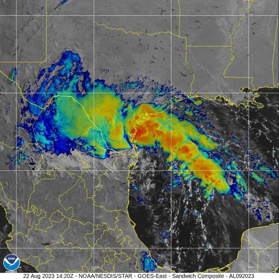
Harold is moving toward the west-northwest near 21 mph and this motion is expected to continue, taking the system farther inland over southern Texas and northern Mexico.
Maximum sustained winds are near 45 mph, with higher gusts. Steady weakening is forecast, and Harold is expected to become a tropical depression later today.
Tropical-storm-force winds extend outward up to 115 miles from the center. An observation in Falfurrias, Texas, recently reported sustained winds of 35 mph with a gust to 60 mph.
The estimated minimum central pressure is 996 mb.
A couple of tornadoes are possible across South Texas through the afternoon.
Tropical Storm Harold is expected to produce rainfall amounts of 2 to 4 inches, with isolated higher amounts of 6 inches, across South Texas through early Wednesday. Scattered instances of flash flooding will be possible.
The combination of storm surge and the tide will cause normally dry areas near the coast to be flooded.
Gert weakens into post-tropical cyclone

Location: 230 miles east-southeast of the northern Leeward Islands
Maximum wind speed: 30 mph
Direction: west-northwest at 5 mph
Maximum sustained winds for Tropical Depression Gert are near 30 mph, with higher gusts. Gert should continue to gradually weaken until the circulation opens up into a trough in a couple of days. The estimated minimum central pressure is 1008 mb.
There will no more public advisories issued on Gert.
What else is out there and where are they?

Invest 92L: Disorganized showers and thunderstorms located a few hundred miles west of the Cabo Verde Islands are associated with a tropical wave.
Formation chance through 48 hours: low, 10 percent.
Formation chance through 7 days: medium, 40 percent.

Environmental conditions now appear only marginally conducive for gradual development of this system, but a tropical depression could still form later this week or over the weekend while it moves west-northwestward to northwestward across the eastern and central Atlantic.
Disturbance 2: The remnants of former Tropical Storm Emily are located over the central tropical Atlantic several hundred miles east-northeast of the Leeward Islands.
Formation chance through 48 hours: low, 10 percent.
Formation chance through 7 days: low, 30 percent.

Although development is unlikely in the next day or so due to unfavorable environmental conditions, some development is possible by Friday or Saturday when the system movesnorthward over the subtropical central Atlantic. The system should move north of the Gulf Stream on Sunday where further development is not expected.
Spaghetti models for Tropical Storm Franklin
Spaghetti models for Tropical Storm Harold
Spaghetti models for Tropical Depression Gert
Weather watches and warnings issued in Florida
When is the Atlantic hurricane season?
The Atlantic hurricane season runs from June 1 through Nov. 30.
When is the peak of hurricane season?

The peak of the season is Sept. 10, with the most activity happening between mid-August and mid-October, according to the Hurricane Center.
Tropical forecast over the next seven days
Excessive rainfall forecast
What's out there?
Systems currently being monitored by the National Hurricane Center.

What's next?
We will continue to update our tropical weather coverage daily. Download your local site's app to ensure you're always connected to the news. And look at our special subscription offers here.
This article originally appeared on Treasure Coast Newspapers: NHC tracking Tropical Storm Harold, Franklin. Spaghetti models, impact

