NHC tracking new system off southeastern US coast that could affect holiday plans
A new disturbance has popped up close to the U.S., and it's one forecasters are watching closely.
The National Hurricane Center said a non-tropical area of low pressure is expected to form offshore the southeastern United States.
While chances currently are low for development in the coming days, it is likely to affect weather in some areas going into the Memorial Day weekend.
AccuWeather forecasters said the system stretches from northern Florida to North Carolina and could bring drenching rain, severe thunderstorms and dangerous surf over much of the Memorial Day weekend.
The National Hurricane Center also continues to track two tropical waves, one in the central Atlantic and the other in the eastern Atlantic.
Super Typhoon Mawar: 'We are at the crosshairs': Guam braces for direct hit from Super Typhoon Mawar
Florida may not catch a break: AccuWeather issues 2023 hurricane season forecast, predicting 11-15 named storms
WMO officially retires Ian name: There will never be another hurricane named Ian
Could a tropical system develop off US before official start of hurricane season?
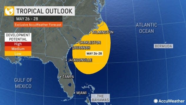
A cluster of thunderstorms will try to develop this week over the warm waters of the Gulf Stream along the southern Atlantic coast, according to AccuWeather.
If the center manages to stay offshore for more than a couple of days, there is a better chance of it evolving into a tropical depression or storm. The best chance of something forming would be from Friday to Sunday.
"It sometimes takes two to three days for a complex of thunderstorms to develop into a tropical system," AccuWeather Hurricane Expert Dan Kottlowski said.
Should the system spiral inland quickly, which is the most likely scenario, tropical development would not occur.
The first named storm of the 2023 Atlantic hurricane season will be Arlene.
What's out there and where are they?
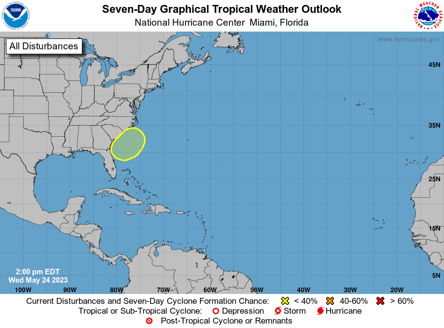
Area off Southeast US coast: A non-tropical area of low pressure is expected to form along a front offshore of the southeastern United States coast during the next day or two. The system appears unlikely to become a subtropical or tropical cyclone as it moves generally north and inland over the Carolinas this weekend.
Tropical wave 1: The first tropical wave is located southwest of Cabo Verde. It's moving west at 11 mph.
Tropical wave 2: The second tropical wave is located east of Grenada. It's moving west at 11 mph.
What are the chances for development?
Formation chance through 48 hours: low, near 0 percent.
Formation chance through 7 days: low, 10 percent.
Who is likely to be impacted?
Regardless of development, the system is likely to produce gusty winds and dangerous surf and rip current conditions along portions of the southeastern United States coast late this week and into the holiday weekend.
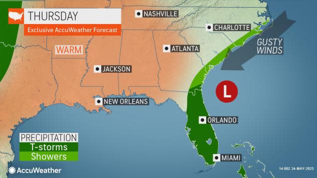
Initially, most of the rain and thunderstorms will be focused on parts of Florida and just offshore Georgia and the Carolinas through Thursday and into Friday, according to AccuWeather.
The worst conditions will occur where the circulation spirals ashore, which is expected from Georgia to the Carolinas. Sporadic power outages and urban flooding are possible, and some of the thunderstorms may bring strong wind gusts and even a waterspout near the coastal waters, according to AccuWeather.
Heavy rainfall is expected in portions of the Carolinas, and hazardous marine conditions are expected over the coastal and offshore waters where gale watches and warnings are in effect.
Cars, jellyfish and rip currents: How to stay safe on the beach for Memorial Day weekend
Forecasters urge all residents to continue monitoring the tropics and to always be prepared since conditions can and do change rapidly.
What's the forecast for the Gulf of Mexico, Caribbean Sea, tropical Atlantic?
Gulf of Mexico: For the forecast, a stalled front across the northern Gulf will move south through the eastern Gulf this afternoon through Friday, bringing north to northeast winds through Saturday morning. A weak system of high pressure will generally dominate the Gulf through the week, with gentle to moderate winds starting Thursday. Seas are will build with the increasing winds behind the front.
Caribbean Sea: A system of low pressure will will move into the northwestern Caribbean Thursday night, where it's expected to stall and linger through the end of the week, bringing a slight increase in winds and seas.
Atlantic: A system of low pressure moving across the southeastern U.S. is forecast to move into the Florida Peninsula over the next couple of days before moving into the Atlantic Thursday. This could bring strong northeast winds and large swells across the Northeast Florida coast beginning Thursday night and spreading southward to near Daytona Beach Friday through Saturday. Northeast gale winds are possible offshore Jacksonville Friday night.
Typhoon Mawar hits Guam
#Mawar is now a super #typhoon with max winds of 155 mph - the strongest western North Pacific typhoon in May since Dolphin (2015). Mawar is looking likely to make a direct hit on Guam. pic.twitter.com/iHt78TgI9C
— Philip Klotzbach (@philklotzbach) May 23, 2023
Typhoon Mawar could strengthen into a Category 5 storm by the time it passes over Guam.
There are about 170,000 residents in the U.S. territory in the western Pacific that could be affected by the strongest typhoon in decades. Meteorologists said Mawar could bring life-threatening flooding, storm surge and the potential for damaging winds over the next few days.
President Joe Biden Tuesday approved an emergency declaration for Guam as the storm approached.
What's the difference between hurricane, typhoon and cyclone?
Hurricanes, typhoons and cyclones are the same thing, with the only difference being where they are, according to NOAA.
In the North Atlantic, central North Pacific and eastern Pacific, the term hurricane is used.
In the Northwest Pacific, the word typhoon is used, and in the South Pacific and Indian Ocean, it's called a tropical cyclone.
Weather watches and warnings issued for your area
If you can't see any local weather warnings here, you'll need to open this story in a web browser.
When is the Atlantic hurricane season?
The Atlantic hurricane season runs from June 1 through Nov. 30.
When is the peak of hurricane season?
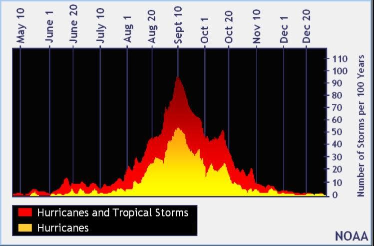
The peak of the season is Sept. 10, with the most activity happening between mid-August and mid-October, according to the Hurricane Center.
Tropical forecast over the next seven days
Excessive rainfall forecast
What's out there?
Systems currently being monitored by the National Hurricane Center.
What's next?
We will continue to update our tropical weather coverage daily. Download your local site's app to ensure you're always connected to the news. And look at our special subscription offers here.
This article originally appeared on Fort Myers News-Press: NHC tracking system off US coast, 2 tropical waves

