NHC watching 3 tropical waves, including 1 showing low chance for development
Almost 30 years after Hurricane Andrew hit Florida as a Category 5 hurricane, the tropics remain fairly quiet.
The National Hurricane Center is watching three tropical waves in the Atlantic basin. One of the systems is approaching the Caribbean and currently has a 20 percent chance of development over the next five days.
► Your guide to preparing for the 2022 hurricane season in Florida
Andrew formed Aug. 16, 1992, the first named storm of the year. It made landfall on Elliott Key, about 23 miles south of Miami. Winds were estimated at 166 mph, according to the Hurricane Center.
Hurricane Andrew: Category 5 Hurricane Andrew broke 42-year lucky streak, shattered illusions of safety for Florida
At the time, it was the third Category 5 hurricane to make landfall in the U.S. since 1935.
Since then, Hurricane Michael hit the Florida Panhandle at Mexico Beach in October 2018 as a Category 5 storm, which estimated winds at 161 mph.
Atlantic hurricane season: The calm before the storms: Why 2022's hurricane season won't stay quiet much longer
WeatherTiger: Shockingly quiet in the tropics as study confirms hurricane season is starting sooner
Here's the latest update from the NHC as of 8 a.m. Aug. 22:
What's out there and where are they?
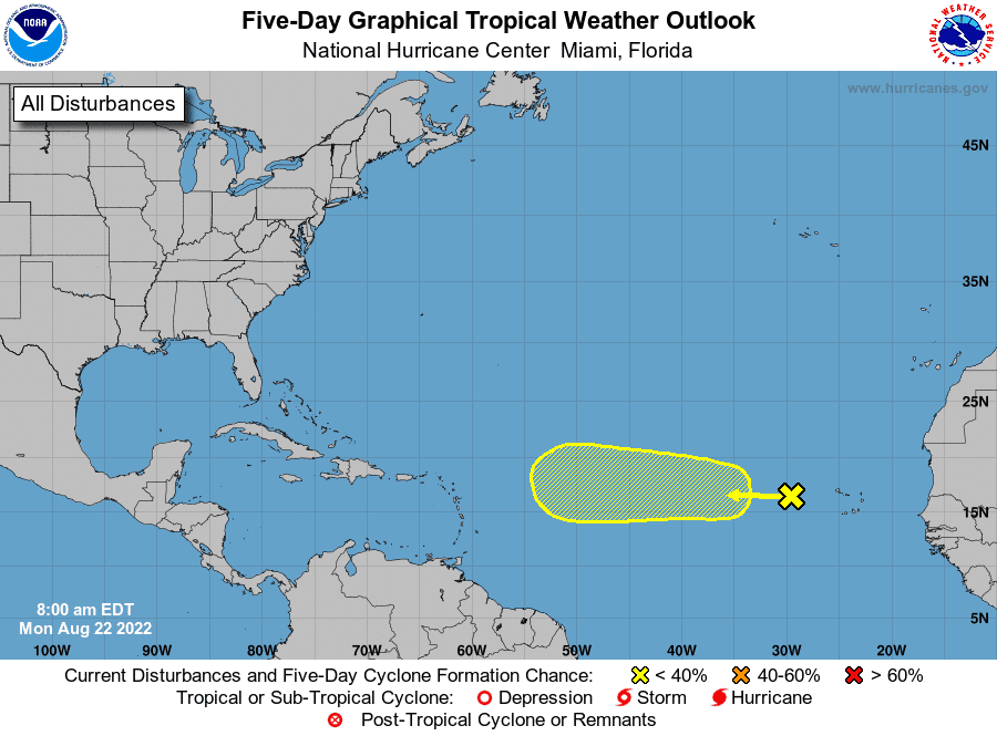
Tropical wave 1: A tropical wave located a few hundred miles west of the Cabo Verde Islands continues to produce disorganized showers and thunderstorms.
Tropical wave 2: A tropical wave in the central Atlantic is located east of Barbados. It's moving west at 17 mph.
Tropical wave 3: A tropical wave in the central Caribbean is located between Panama and Jamaica. It's moving to the west at 17 mph.
How likely are they to strengthen?
Tropical wave 1: Environmental conditions could support some slow development of this system while it moves west to west-northwest at around 10 to 15 mph across the tropical Atlantic during the next several days.
Formation chance through 48 hours: low, near 0 percent.
Formation chance through 5 days: low, 20 percent.
Who is likely to be impacted?
It's too early at this time to determine if there will be any impact to the U.S. from the tropical waves.
Forecasters urge all residents to continue monitoring the tropics and to always be prepared during what's expected to be an active hurricane season.
Early predictions: CSU, AccuWeather forecasters agree: Active hurricane season ahead. Here's what you need to know
WeatherTiger prediction: Since 2017, a ludicrous 101 named storms have formed. Expect more this hurricane season
Colorado State University's 2-week forecast for Aug. 18-31
CSU has issued 2-week Atlantic #hurricane forecast (Aug. 18-31) and gives highest odds for near-normal activity (70%) with below-normal & above-normal both given 15% chances. Tropical cyclone activity is likely to increase later in the period:https://t.co/8GXmlarsze pic.twitter.com/ID9ZEHYIfG
— Philip Klotzbach (@philklotzbach) August 18, 2022
Meteorologists forecast normal hurricane activity over the next two weeks, with a 15% chance of above-normal activity and a 15% chance of below-normal activity.
Tropical cyclone activity is likely to increase later in the period.
When is the Atlantic hurricane season?
The Atlantic hurricane season runs from June 1 through Nov. 30.
When is the peak of hurricane season?

Although the season has gotten off to a quiet start, the peak of the season is Sept. 10, with the most activity happening between mid-August and mid-October, according to the Hurricane Center.
WeatherTiger: Ominous steering currents for Florida may be on horizon as quiet hurricane season persists |
Revised seasonal forecast: Atlantic hurricane season off to slow start. But top forecasters still expect above-normal activity
Weather watches and warnings issued for your area
If you can't see any local weather warnings here, you'll need to open this story in a web browser.
The next five days
See the National Hurricane Center's five-day graphical tropical weather outlook below.
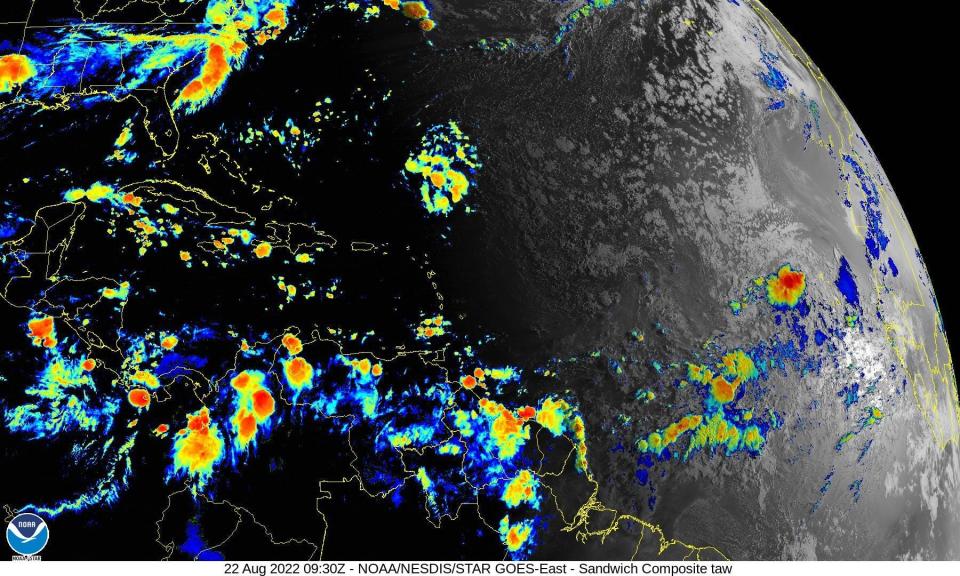
Excessive rainfall forecast
What's out there?
Systems currently being monitored by the National Hurricane Center.
What's next?
We will continue to update our tropical weather coverage daily. Download your local site's app to ensure you're always connected to the news. And look at our special subscription offers here.
This article originally appeared on Palm Beach Post: Tropics watch: Tropical wave approaching Caribbean, 2 others watched

