Nicole could bring tropical storm force winds to Sarasota-Manatee after Atlantic landfall
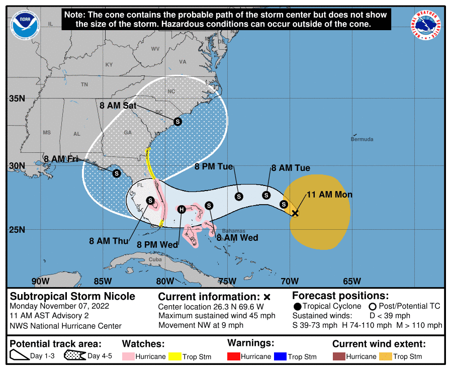
Subtropical Storm Nicole, the center of which was still more than 800 miles east-southeast of Tampa late Monday morning, is projected to make landfall on the Atlantic coast of Florida near Palm Beach County Wednesday night as a Category 1 Hurricane.
The National Hurricane Center has issued hurricane and storm surge watches for most of Florida's East Coast.
Gov. Ron DeSantis on Monday declared a state of emergency for 34 counties in the storm's potential path, including Charlotte, Manatee and Sarasota.
“While this storm does not, at this time, appear that it will become much stronger, I urge all Floridians to be prepared and to listen to announcements from local emergency management officials,” said DeSantis. “We will continue to monitor the trajectory and strength of this storm as it moves towards Florida.”
What are the Florida counties under a state of emergency?
The counties under a state of emergency: Brevard, Broward, Charlotte, Citrus, Clay, Collier, DeSoto, Duval, Flagler, Glades, Hardee, Hendry, Highlands, Hillsborough, Indian River, Lake, Lee, Manatee, Martin, Miami-Dade, Nassau, Okeechobee, Orange, Osceola, Palm Beach, Pasco, Polk, Putnam, Sarasota, Seminole, St. Johns, St. Lucie, Sumter, and Volusia.
Tropical storm force winds, which are winds greater than 39 mph, are projected to reach Charlotte County as early as 3 p.m. Wednesday but likely by 1 a.m. Thursday, followed by arrival in Sarasota and Manatee counties as soon as 5 p.m. Wednesday and likely by 2 a.m. Thursday in Sarasota and 3 a.m. Thursday in Manatee.
The estimates were provided by the National Weather Service in Ruskin as it monitored the system. Forecasters said strong tropical storm winds between 58 and 73 mph were possible in neighboring Highlands County Wednesday night and Thursday.
Related: Hurricane watch issued for much of Florida's East Coast
The storm currently had sustained winds of 45 mph in the Atlantic and was moving northwest at 9 mph, with a broad center of rotation.
A large wind field is anticipated on the northern part of the storm because of high pressure to the north, according to the National Weather Service.
Paul Close, a meteorologist with the National Weather Service in Ruskin, said that, based on the storm’s current track, while the wind from the system may extend out toward the Gulf of Mexico, most of the rainfall in this region should occur in the central part of the state.
“It’s not going to be a 10- to 15-inch rain; it's two to four (inches) mostly, maybe some higher in spots,” Close said. “Not outrageous amounts like we had with Hurricane Ian.”
Once that rain arrives, it could persist through Friday, according to the weather service.
Close noted that since named storm rain forecasts typically start at a 48-hour window, Monday morning was too soon for an accurate prediction. Forecasters said Thursday has the best potential for flooding rain on urban streets, rivers, and creeks
By the numbers: One month has passed since Hurricane Ian
By midday Monday, Nicole was a large, messy system with the strongest winds more than 60 miles from the storm center and not along the storm center, as would be expected with a more tropical system.
Area residents still recovering from Hurricane Ian who have taken part in the U.S. Army Corps of Engineers Operation Blue Roof program can expect the covering to withstand tropical storm force winds but that's not an ironclad guarantee.
“Each home is individually installed and there are too many variables to come up with a specific windspeed that they will withstand," U.S. Army Corps of Engineers spokesperson Shannon Bauer wrote in a Monday email. "That being said, they are resilient.
"As an example, 88% of the Blue Roofs that were installed after Hurricane Laura withstood winds from Hurricane Delta (CAT 1) in Louisiana in 2020.”
Meanwhile tides could be three to four feet above normal, with the Nature Coast and Cedar Key, north of Tampa Bay, at risk for a storm surge if Nicole makes it into the Gulf of Mexico.
There is a marginal risk of excessive rainfall in Central Florida from north of Punta Gorda to Lake Okeechobee.
The Little Manatee River at Wimauma has a small chance of moderate flooding Friday and the Peace River and Horse Creek may rise back to minor flood stages Friday or Saturday.
Close noted that the Myakka River at Myakka State Park is currently at 5 feet, so there is a possibility that it could reach a minor flood stage of 7 feet, depending on the path of the storm.
Earle Kimel primarily covers south Sarasota County for the Herald-Tribune and can be reached at earle.kimel@heraldtribune.com.
USA TODAY Network-Florida government accountability reporter Douglas Soule contributed to this report.
Support local journalism with a digital subscription to the Herald-Tribune.
This article originally appeared on Sarasota Herald-Tribune: Subtropical Storm Nicole may bring tropical storm force winds to Sarasota, Manatee

