Nicole: Tropical storm is expected to become a hurricane Wednesday as evacuations ordered
An advancing Tropical Storm Nicole consolidated its most potent winds Tuesday, circling its core with a burst of energy in a move that designated it a true tropical cyclone, set off hurricane warnings from Boca Raton to Daytona Beach and triggered the evacuations of tens of thousands of Palm Beach County residents.
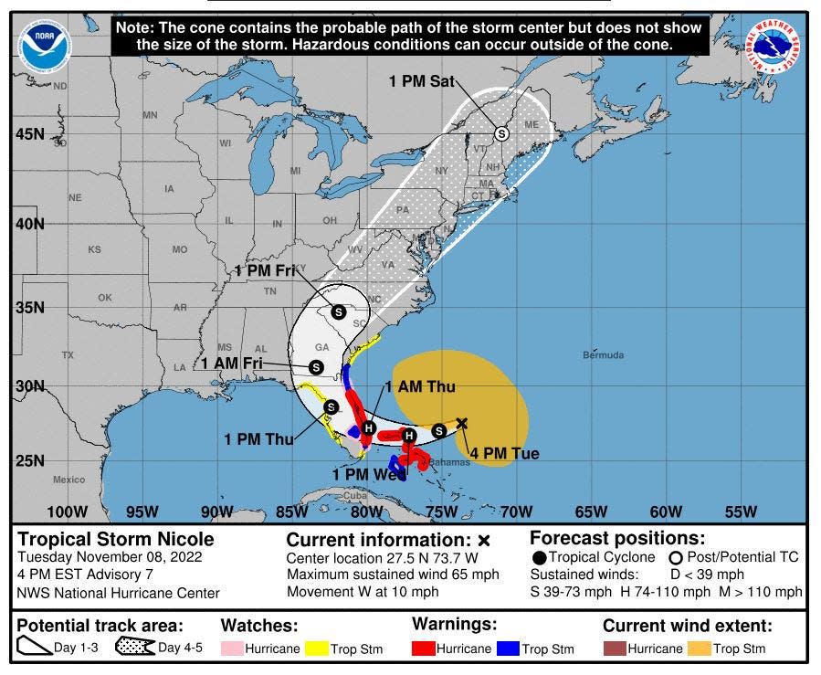
The deepening system, which is expected to make landfall along Florida’s east coast as a Category 1 hurricane late Wednesday into early Thursday, also maintained an astounding 380-mile sweep of tropical storm-force winds.
CLOSURES: Tropical Storm Nicole: Palm Beach County schools, some colleges to close Wednesday, Thursday
LIVE UPDATES: Palm Beach County evacuations issued for zones A and B
►BE PREPARED: The complete Hurricane Preparation Guide
It’s a turbulent spread that guarantees far-flung strafing from damaging gales, flooding from heaving storm surge and a deluge of prodigious rainfall.
And it’s one element in Palm Beach County’s decision to evacuate its most vulnerable areas in zones A and B, which includes an estimated 52,000 residents in mobile homes and 67,000 residents on barrier islands. Mandatory evacuations begin Wednesday at 7 a.m. with shelters opening at the same time.
“Please take these mandatory evacuations seriously,” said Palm Beach County Administrator Verdenia Baker. “If you want to evacuate and leave the area or the state, now is the time to do it. Tomorrow is too late.”
Nicole’s center is forecast to breach Florida's coast somewhere between Boca Raton and Cape Canaveral. Sustained wind speeds are expected to top out at 75 mph with 90 mph gusts before it weakens to a tropical storm inland and makes a sharp turn north.
The last time Palm Beach County issued evacuation orders was during 2019’s Hurricane Dorian.
County asks people not to evacuate too far away to avoid creating traffic
Baker asked that people evacuate tens of miles not hundreds of miles, which can lead to a mass exodus and Peninsula-long traffic snarls as the storm is approaching. Shelters include Palm Beach Gardens High School, Independence Middle School, Palm Beach Central High School, Dr. Mary McLeod Bethune Elementary, Park Vista High School, Lake Shore Middle School and Pahokee Middle School. A pet-friendly shelter will open at West Boynton Recreation Center.
Palm Beach County schools are closed Wednesday and Thursday. Palm Tran will suspend service at noon Wednesday.
Don't panic, be prepared: Hurricane preparation: What supplies do you need for a storm? Here's a list
Hurricane prep myths: Taping windows before a storm? Don't fall for these hurricane myths
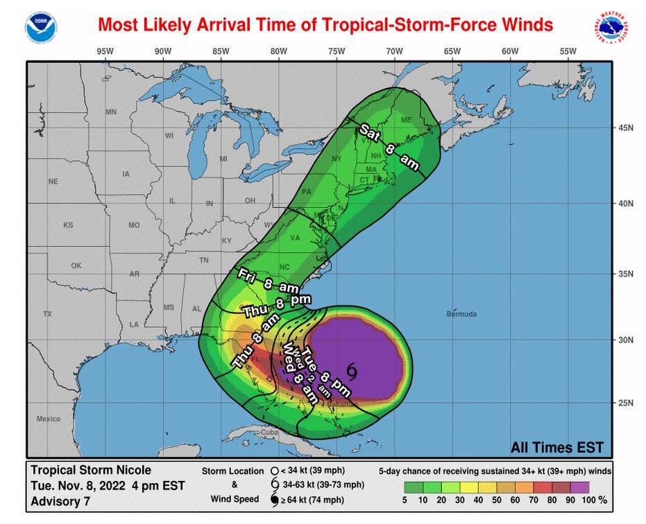
Sustained tropical storm-force winds are expected to reach Palm Beach County early Wednesday evening. Nicole’s track shifted slightly north throughout the day Tuesday but then went south again, keeping all of Palm Beach County and the Treasure Coast in the track cone.
National Hurricane Center experts emphasized the tremendous size of the storm will mean impacts well outside the cone, which solely maps where the center of the cyclone may go. The storm tracks outside of the cone about 33% of the time.
“This is not just a wind event. We have a lot of water coming at us with Nicole,” said Michael Brennan, acting deputy director of the National Hurricane Center. “We are expecting Nicole to take advantage of the warm waters and intensify to a hurricane.”
A generous portion of the Peninsula from Palm Beach County through Gainesville and into the Big Bend region was in Nicole’s forecast cone Tuesday.

Hurricane warnings were issued early Tuesday for Palm Beach County to the Flagler / Volusia County line. A storm surge warning from North Palm Beach to Altamaha Sound Georgia was also issued. Up to 4 feet of storm surge is forecast for North Palm Beach to Hallandale Beach. Areas north of North Palm Beach, including Jupiter, could experience 3 to 5 feet of surge.
With higher than normal tides because of November’s full moon and days of heavy waves, the Town of Palm Beach used cranes to lift its lifeguard stands off Midtown beach Tuesday morning to protect them from encroaching seas.
Chief lifeguard Craig Pollock said he hasn't had to remove the stands in years.
"It's better to be safe than sorry," Pollock said. "We don't have a lot of real estate here in front of the main tower so we need to get them off the beach."
Pollock said a strong northerly current was sweeping south along the coast.
"It's not super friendly out there," he said.
Tropical Storm Nicole 7 p.m. update: 65 mph sustained winds
Tropical Storm Nicole was about 360 miles east of West Palm Beach, moving west-southwest at about 10 mph and carrying maximum sustained winds of 65 mph, the National Hurricane Center said in its 7 p.m. update Tuesday.
Meteorologists projected Nicole would become a hurricane by Wednesday.
A hurricane warning remained in effect for all of Palm Beach County and a storm surge warning from North Palm Beach to the Georgia line.
The hurricane center said Nicole's center will approach the northwestern Bahamas overnight, move near or over those islands Wednesday and then approach Florida's east coast. Meteorologists projected landfall early Thursday.
The storm was expected to continue to head west-southwest before shifting to the west-northwest sometime Wednesday, according to the hurricane center's forecast.
As of 4 p.m. Nicole had sustained winds of 65 mph and was 395 miles east of West Palm Beach.
Meteorologists were confident Nicole would not strengthen above a Category 1 storm despite being emboldened by favorable upper-level winds and feeding on broth-warm waters of 82 degrees.
“To be clear, there is zero chance that Nicole could blow up into a Hurricane Ian or Dorian,” said Fox Weather hurricane expert Bryan Norcross, who is based in Miami. “I don’t see any likelihood of it being more than a Category 1.”
Most of Palm Beach County had between a 5 and 10% chance of getting hurricane-force winds as of Tuesday afternoon. But there was a 50 to 90% chance for tropical storm-force winds, with the highest winds being in the northern part of the county.
Water managers said community lakes likely will rise and there may be street flooding with the 4 to 6 inches of rain predicted along the coast, but any flooding should be short-lived.
"It's not devastating," said Lake Worth Drainage District Executive Director Tommy Strowd about the rainfall forecast.
In fact, the district has been pumping in water from South Florida Water Management District canals to keep levels high enough to avoid saltwater intrusion. Strowd said Nicole's rains may help with water supply through the dry season.
"We are in this unusual time of year where this typically is the dry season and it has been very dry," Strowd said. "It’s fortunate in a way that after this rain we may have some added water stored in the canals and lake systems."
While Palm Beach County and the Treasure Coast didn’t suffer extensive beach erosion from Hurricane Ian, a recent spat of onshore winds has forced the closure of at least one popular Martin County beach. Vincent Encomio, University of Florida Sea Grant Extension Agent, said Bathtub Beach in Stuart was recently closed because of erosion.
Nicole's triple bad combination could create a worst-case scenario
The combination of Nicole’s storm surge, days of high waves and a higher-than-normal tide is a worst-case scenario for the coast, he said.
“When we get into full tropical storm conditions by Wednesday night, seas 20 nautical miles out will be over 25 feet with the occasional 36 feet,” said Encomio, who has lived in Stuart since 2008. “I personally have never seen that since I’ve lived here.”
Nicole, which formed as a subtropical storm early Monday, has been called an “oddball” and “bizarre” and “unusual.”
It's not because the storm formed in November, but because of the westerly track it's taking toward the state. Most November tropical cyclones that approach Florida form in the warm waters of the Caribbean Sea or Gulf of Mexico, get picked up by a dip in the jet stream and then are hurled at the state from the south or southwest.
Nicole formed after a very deep dip in the jet stream interacted with a weak disturbance in the Caribbean, starting out as subtropical then turning tropical. It’s now riding under the clockwise flow of an area of high pressure toward Florida and should get pulled north on Thursday by another dip in the jet stream.
“Nicole still has a lot of story left to tell,” said Robert Garcia, a National Weather Service meteorologist embedded with Palm Beach County’s emergency operations center.
This article originally appeared on Palm Beach Post: Tropical Storm Nicole expected to reach hurricane strength before landfall

