NJ experienced a record warm January. What's the outlook for the rest of winter?
New Jerseyans who wait all year in anticipation for snow bluffs, crisp air and all things winter have so far been denied the things they love.
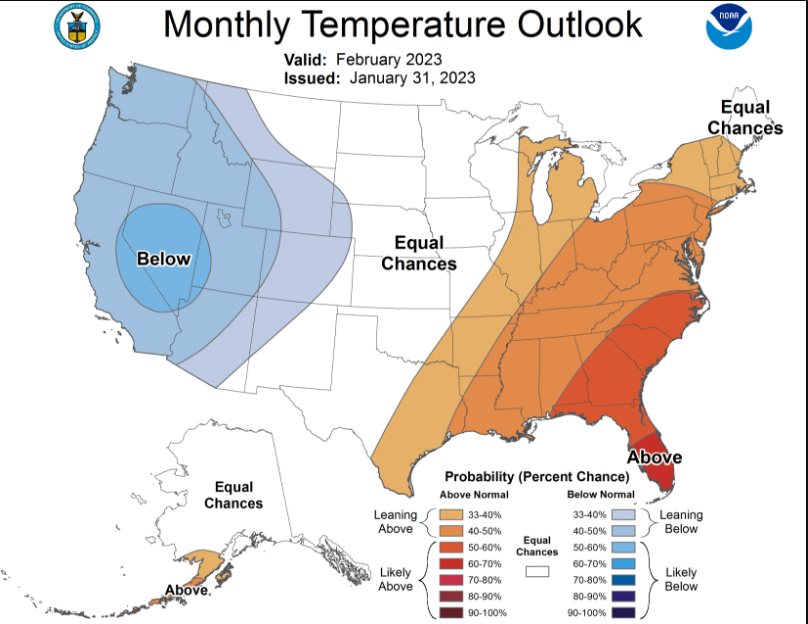
And it doesn't look like it's going to change soon.
New Jersey tied a record for the warmest January in more than a century of record-keeping with snowfall that ranged from "meager in the north to non-existent further south," according to a report released Thursday by Rutgers University.
The state's weather "was more like that of the piedmont of North and South Carolina at this time of year," wrote David Robinson, the state climatologist.
The statewide average temperature of 41 degrees was 9.3 degrees above the normal average for 1991 to 2020. It tied with 1932 as the mildest January since 1895. The weather was so reminiscent of March that Robinson titled his report "Does Anybody Really Know What Month It Is?"
While there is enough time for significant snowstorms and bone-chilling temperatures this winter, the National Weather Service is predicting higher-than-normal temperatures for the Northeast for the rest of winter into April. Forecasts for North Jersey call for highs in the mid-40s to mid-50s over the next 10 days.
January may be the start of a record warm year — continuing a trend seen in New Jersey recently.
Last year was tied with 2019 and 2022 for the 12th warmest on record with a statewide average of 54.3 degrees.
All but one of the top 20 warmest years in New Jersey history have come since 1990, according to Robinson's data analysis.
The overwhelming majority of scientists, peer-reviewed studies and government agencies have shown that the planet is warming due in large part to human activity. Burning fossil fuels such as coal, natural gas and gasoline has increased the concentration of carbon dioxide in the atmosphere, preventing heat from escaping into space.
Story continues below gallery
January's average snowfall of half an inch was ranked third lowest in New Jersey since records have been kept. Most areas south of Interstate 78 did not see measurable snowfall until Feb. 1 - the latest ever in New Brunswick whose prior record for late snowfall was Jan. 31, 1921.
"Now we'll see if seasonal records will be in jeopardy," Robinson said. "It's a long way to go this season before that becomes a topic of discussion."
This article originally appeared on NorthJersey.com: NJ had warmest January on record. What will rest of winter bring?

