NJ homeowners are using old flood data to protect their homes, putting 'lives at risk'
It was when fish swam through the air conditioning vents in the floor that Tony Kono knew he had a problem.
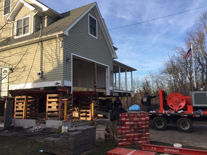
Kono’s house in Brick, near the mouth of the Metedeconk River, had been elevated 7-feet above sea level before Superstorm Sandy hit. The height wasn’t enough. On that Oct. 29 day, 10 years ago, water and other uninvited guests poured into his three-story, four-bedroom home.
"It was built to the old flood standard," Kono said.
After Sandy, Kono, now 61, and his wife elevated their home an additional four feet, at a cost of $150,000. FEMA covered the expense, he said.
Like Kono, Jersey Shore homeowners will find their homes — built based on old flood records — will be insufficiently protected from future storms as sea levels rise and storms grow in intensity, say flood hazard experts.
And while promised new state rules could force new construction to build higher and outside of the flood zones, they remain mired in thorny disputes between homeowners, business groups and government, delaying their release indefinitely.
Left to sort through it all are New Jersey homeowners, who have been ping-ponged between state and local battles over flood rules. What they are working with is not good enough, experts say.
Federal flood insurance rate maps are often the tools used to guide storm- and flood-resistant construction along the Jersey Shore. Yet numerous experts, and even New Jersey's Department of Environmental Protection, say the data used in the maps is in many cases out of date and fails to consider rising water levels along the coast.
And the National Flood Insurance Program, which the maps support, pays out far more than it collects in premiums. As of June, it owed more than $20 billion to the U.S. Treasury. Some of New Jersey's near 200,000 policyholders have seen their rates increase by as much as 25% in recent years, with the average policy nearing $1,000 a year.
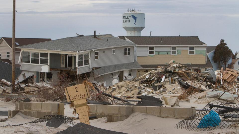
Superstorm Sandy resulted in $8.9 billion in payouts nationally, according to FEMA, more than a third of which — $3.8 billion — went to New Jersey.
"Because of our past and existing emissions, the climate risks facing New Jersey will only worsen in the years ahead, with devastating impacts to our communities, economy, public health, and the daily lives of our residents if we are not prepared," said Shawn LaTourette, the commissioner of New Jersey's Department of Environmental Protection during testimony in August before a meeting of the state Senate Environment and Energy Committee.

Detailed regulation proposals focused on where to restrict new construction and how high the new building codes in flood zones will be in the future remain in discussion.
Jennifer Coffey, executive director of the New Jersey Association of Environmental Commissions, a group that educates appointees who advise municipal officials on local environmental decisions, said she worked with the DEP to draft the proposed regulations and expressed frustration when they were not released earlier this summer. Without action, people will continue to live in harm's way, she said.
"We can't keep allowing this. It is putting people's lives at risk," she said.
In the absence of the state rules governing new building heights in flood zones and where people can build, the federal flood insurance rate maps remain a primary tool for construction and land use decisions around the Jersey Shore.
Across New Jersey, 549 out of 566 municipalities participate in flood prevention efforts so their residents can buy insurance through the National Flood Insurance Program. By participating in the state's Community Rating System — establishing dams, stormwater management systems and other hazard mitigation programs — New Jersey communities can receive up to a 45% premium reduction on their flood insurance bills. Yet experts say the program's maps fail to consider the science on rising ocean levels and increasingly intense trends in rainfall across New Jersey, powerful forces that are reshaping local communities year by year.
Regulations need to reflect changing climate conditions and new construction needs to be moved out of flood-prone areas, Coffey said.
Powerful storms that are predicted to happen only once in a 100-year period or once in a 500-year period are now happening routinely, she said.
"Since 1999, New Jersey has had seven 100-year storms and three 500-year storms," she said. "To me, that says our math is off. (The) 100-year storm is no longer the same as it used to be. They're bigger now. So, the whole probability analysis needs to change."
Changing conditions
Around New Jersey, sea levels are rising faster than across the globe due to the sinking of the Mid-Atlantic coast, a process called subsidence. As a result, between 1979 and 2019, sea level rose along the Jersey Shore by 8.2 inches, compared to 4.3 inches in coastal communities around other parts of the world, according to Rutgers University's 2019 Rising Seas and Changing Coastal Storms report.
At the same time, the Federal Emergency Management Agency's flood insurance rate maps do not factor this sea level rise and other elements of climate change into their risk calculations for homeowners.
"In our flood maps and our flood insurance rate maps, we do not map future conditions," said Michael Foley, chief of the risk analysis branch of FEMA's Region 2, which includes New Jersey.
Trends in sea level over the past century show levels are rising and are likely to continue for decades to come. Yet flood insurance rates and the resulting building standards are backward looking in time.
Knowing that homeowners and municipalities need better risk assessment tools, a group of Rutgers researchers launched a mapping system that illustrates rising sea levels and storm surges across the Shore. The tool, called NJ Flood Mapper, enables users to see their neighborhoods under different greenhouse gas emissions scenarios, through various sea level rise projections, and in several types of storm conditions.
Marjorie B. Kaplan, associate director of the Rutgers Climate Institute and co-director of the New Jersey Climate Change Resource Center, says NJ Flood Mapper is a guidance and preparation tool, but has no effect on regulations or building codes.
Remembering Sandy:Barnegat Lighthouse to go back into service on Oct. 29, DEP says
Changing such regulations and flood risk zone boundaries are "a really thorny, difficult issue, because you're dealing with where people live," said Kaplan.
Superstorm Sandy in 2012 highlighted many problems with the FEMA maps. At the time, FEMA was in the process of updating its maps, but the storm struck before the process was complete, said Foley, of the federal agency.
Without accounting for sea level rise and climate change, the FEMA maps will continue to inaccurately reflect flood risks, said James Shope, a Rutgers University climatologist who specializes in flooding and erosion risk from changing ocean levels. Maps that look to the past will underestimate the future flood levels, he said.
Rutgers experts estimate sea level has a 50% likelihood of rising nearly 10 inches along the Jersey Shore by 2030 over its 2000 levels. By 2050, Shore communities have a 50% likelihood of seeing the ocean nearly 17 inches higher than it was in the year 2000, according to the university's climatologists. Such an increase would inundate low-lying streets on Long Beach Island and the northern barrier island, Point Pleasant Beach and Tuckerton, to name just a few of the affected neighborhoods around the Jersey Shore, according to NJ Flood Mapper.
Since 1992, global sea levels have already risen nearly 4 inches, according to NASA. Rutgers University scientists say sea levels along New Jersey are 18 inches higher today than they were in the early 1900s. The rising water, and repeated battering from storms, destroyed the town of South Cape May, much of which now lies within the Atlantic Ocean. What is left above water is preserved as a bird sanctuary.
Farther north, more than 24,000 Ocean County residents and more than 11,000 Monmouth County residents live in homes within 2 feet of current sea levels, according to the National Oceanic and Atmospheric Administration.
Lisa Auermuller, assistant manager at the Jacques Cousteau National Estuarine Research Reserve in Tuckerton who studies coastal resilience, said because FEMA maps do not consider rising water levels, they are not the best tools to guide future planning.
"We're trying to use an insurance-based tool… to make decisions about safety," she said. "They weren't ever intended to be used like this."
Sandy recovery: 10 years after Sandy, church-based group still delivers free furniture, no questions asked
Auermuller is helping to run another flood mapping project, called MyCoast. Through a web portal, contributors upload photos of flooding around New Jersey. Using the photo's background data, scientists then trace information about the location's weather and tide information. Afterward, that data is also shared to NJ Flood Mapper, she said.
"It's that kind of crowdsourcing tool where we let residents become part of that resilience discussion, by adding what they see every day in their own backyard to the data collection," she said.
The pushback on maps
At the federal level, FEMA remains in the process of issuing new flood risk maps for New Jersey, a process that started before Superstorm Sandy. Their release has been delayed by an appeal from New York City, which fought the flood insurance rate maps released in 2015. At the time, lawyers for the city argued that FEMA overestimated the size of the city's 100-year storm floodplain and the base flood elevation. As a result, the flood maps would have forced more property owners to purchase flood insurance.
In 2016, the city won its appeal and FEMA was forced to redraw its insurance rate maps.
The preliminary insurance rate maps should be released sometime in 2024 and begin their review process, said Foley, of FEMA. If they are not appealed, they should be adopted by 2025, he added.
Across much of New Jersey, many homeowners remain unsure about their flood risks. Although the state requires flood risk disclosure, its rules are weak compared to states with more stringent disclosure laws, such as Louisiana and Texas, according to FEMA.
"Most people don't understand where the flood zones even are and where homes might be in flood zones," said Lucas Marxen, associate director of Rutgers University's Office of Research Analytics, which helped construct the software for NJ Flood Mapper.
Within New Jersey's property tax system "there is actually a designation for whether a property is in a flood zone, and of the 3 million plus properties in New Jersey, zero of them are marked off," he said.
That uncertainty about flood risk has led to costly consequences. In recent years, the National Flood Insurance Program has paid out more than it has collected in premiums. In October 2017, Congress canceled $16 billion in debt to keep the program afloat.
When FEMA changed flood insurance rates for homeowners across the nation last year, the agency faced fierce pushbacks in many communities. Some homeowners saw price hikes of between 5% to 18% a year — or 25% a year for vacation homes. New Jersey homeowners with flood insurance pay on average $960 a year for coverage, according to an analysis of flood insurance rates by Forbes.
Some politicians insisted the rate hikes would drive homeowners out of the insurance program and, as a result, expose more people to significant financial risks from flood damage.
Interactive:Rising seas, shrinking coasts
Despite the increase, about 198,000 National Flood Insurance Program policies are active in New Jersey, according to FEMA. Of those, nearly 9% of New Jersey flood insurance policyholders saw their policy premiums drop $100 or more per month under the new calculation, according to FEMA data. However, nearly 80% of New Jersey policyholders saw their monthly premium increase under the new rates. Of those, 63% saw monthly premiums rise by less than $10, 10% saw monthly rates increase between $10 and $20, and 5% saw their payments increase more than $20 per month.
Congress remains under pressure to keep those insurance premiums affordable, despite the financial losses. Shore homeowners, too, want to continue to affordably live in some of New Jersey's move beautiful places, despite the risks.
"It's so much more complicated than 'what can we just do to fix it?'" said Auermuller, of the Jacques Cousteau reserve. "It's a social science problem. It's a mapping problem. It's a climate science problem… It's going to take a shared vision and understanding a dynamic place."
Demands for action
Already around New Jersey's waterfront communities, a crisis has emerged. Municipalities are finding their stormwater systems and pump stations are not equipped to respond to increasing rainfall and rising tides.
"The problem is we have climate change, and our climate is changing rapidly," said Coffey, of the New Jersey Association of Environmental Commissions. "We have significantly more rainfall now than we did in 1999 alone, and certainly more than we did in 1899."
Rainfall amounts in New Jersey are 2.5% to 10% higher than precipitation guidelines established in 1999 estimated, according to the Department of Environmental Protection. Those guidelines are used in development and construction planning.
In addition, rainfall amounts are likely to increase more than 20% from 1999 levels over the course of the century, according to the DEP. The agency is proposing rules that would require all new construction and redevelopment in inland and river flood risk areas to be elevated two feet above the current state requirements and three feet above the FEMA requirements.
On Wednesday and Thursday, the department will hold two virtual public meetings about the implications of the proposed rules.
Coffey said New Jersey must move beyond its patchwork-style regulations to deal with water problems that flow across regions and watersheds, she said.
"You can't fix New Jersey's flooding problems by working on one square mile of a community at a time," she said. "We need a larger regional and statewide approach."
The Department of Environmental Protection said Murphy's administration is "committed to building the state's resilience to extreme weather, including flood risks exacerbated by our changing climate," but noted that the proposed rules were undergoing "ongoing deliberations."
Rebuilding after Sandy:Camp Osborn prepares to rebuild, a full 10 years after Sandy
The business community remains worried about the proposed flood hazard rules and what they could mean for the state's future.
"The devil is always in the details," said Raymond Cantor, vice president of government affairs for the New Jersey Business and Industry Association and a former assistant commissioner at the state Department of Environmental Protection. "We largely agree that we need to take more proactive actions to both make the coasts more resilient, and also to change our regulations to take into account future sea level rise."
But Cantor questioned some earlier discussions with Department of Environmental Protection officials about raising flood elevation standards by multiple feet.
"We think the DEP should be proposing a two-foot sea level rise and flood hazard standard now, and let's see what happens over the coming decade," he said. "If we need to adjust, we have decades to adjust."
In the meantime, Foley, of FEMA, said his office is working with LaTourette's team to create an overlay map for flood risk, one that includes climate change science that could be used by homeowners, municipalities and businesses to better prepare for the future.
"That way, there's… one product out there that will have FEMA's special flood hazard areas identified on the maps and then also show the potential risk with sea level rise in the future," said Foley. "From a standpoint of a citizen or business or someone making a decision, they have all this information in front of them to make some smart decisions moving forward, based on risk."
However, mandatory insurance purchases and community-wide floodplain management programs, used to lower insurance rates for groups of homeowners, will remain tied to the FEMA maps, which "do not account for future conditions," Foley said.
New Jersey remains, for now, without a statewide, comprehensive flood management program, said Kaplan, of the Rutgers Climate Institute.
"You need a whole-of-government approach and you need resources," she said. "Until that time, we're just chipping away at it."
Amanda Oglesby is an Ocean County native who covers Brick, Barnegat and Lacey townships as well as the environment. She has worked for the Press for more than a decade. Reach her at @OglesbyAPP, aoglesby@gannettnj.com or 732-557-5701.
This article originally appeared on Asbury Park Press: FEMA flood zone maps for NJ are inaccurate, say experts. Why

