NJ snow forecast: Winter storm watch issued for Monday. How much could we get?
UPDATE: Winter storm watch upgraded to a winter storm warning for North Jersey. See details here.
It could be a difficult commute Tuesday morning, the National Weather Service's office in Upton, New York said with a winter storm watch in effect for North Jersey from Monday night into Tuesday.
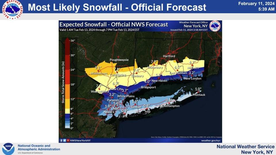
"The storm will bring a period of moderate to heavy snow inland, and rain transitioning to a rain/snow mix down to the coast," the agency said, predicting 2-4 inches for portions of Northeast New Jersey closer to the coast, 5-9 inches for interior Northeast areas.
The service's expected snowfall amounts lowered between 1-2 inches from Saturday late afternoon into the Sunday morning forecast. Paramus looks to be charting to get a little over 3 inches (3.2) compared to Saturday's forecast of 4.2 inches. West Milford still is expecting a healthy amount: nearly 8 inches (7.7) compared to the predicted 9.
"Subtle shifts in track north or south will impact the location of heaviest precipitation and where the rain/snow line sets up," the agency cautioned Saturday. "This will be key in determining forecast snowfall amounts, particularly for the city/coast, in an air mass only marginally cold enough to support snow."
Here's what we know as of Sunday morning. Check back with us as the forecast develops.
Today
Sunday will be mostly cloudy with the high temperatures in the 40s to around 50. But temperatures are expected to dip back to around 30 degrees by nighttime.
Monday and Tuesday
The Weather Service expects Monday to be partly sunny, with temperatures in the high 40s. Then, temperatures are expected to drop to the low 30s, with rain expected into early Tuesday morning before turning to snow.
The path of the storm will be telling, the New York bureau said Sunday. The more north it travels, the snowfall totals will be less. If it sticks to the south, inland snow totals might drop but there could be a greater chance for accumulation near the coast.
And winds could factor in. "Gusty winds and minor to moderate coastal flooding impacts are also possible," the agency's New York office said.
This article originally appeared on NorthJersey.com: North Jersey forecast: Major snowstorm could follow mild weekend

