Potential tropical storm could bring more rain, wind than Hurricane Lee. What to know.
For the most recent coverage of Tropical Storm Ophelia and its potential impacts on Rhode Island, go here: https://www.providencejournal.com/story/weather/hurricane/2023/09/22/ri-weather-tropical-storm-ophelia-forms-what-the-storm-means-for-rhode-island/70933277007/
Enjoy one more day of beautiful weather, because the weekend will bring cooler temperatures and potentially a lot of rain from a system moving up the East Coast that could develop into a tropical storm, forecasters say.
A week after Hurricane Lee mostly fizzled in Southern New England, an as-yet nameless storm "is likely to bring gusty winds and rounds of heavy rain to much of the East Coast," AccuWeather quotes Senior Meteorologist Tyler Roys saying.
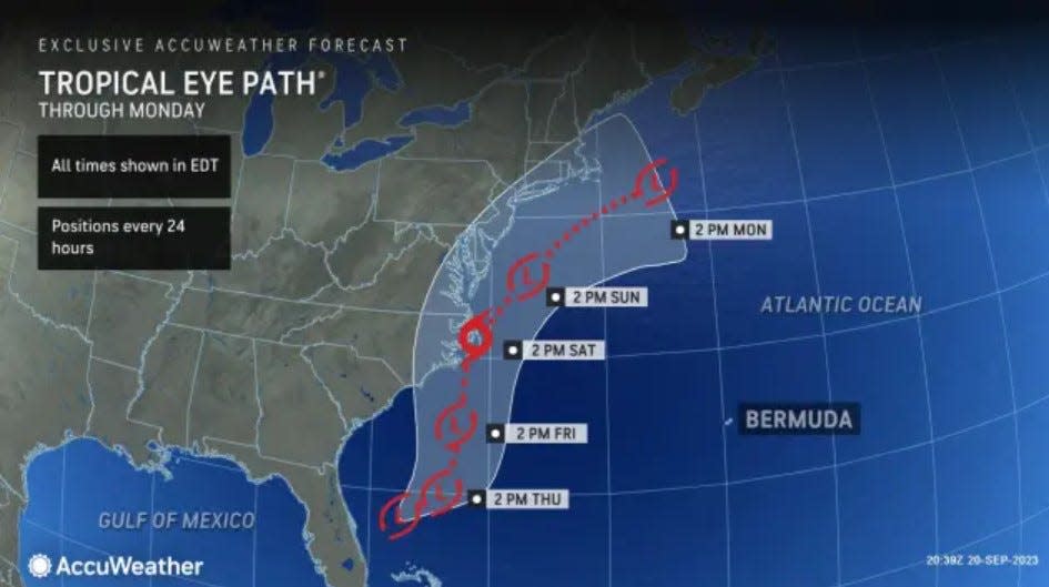
As of Friday morning, it looks like the worst impacts from the storm will stay south of New England. What the National Hurricane Center is now calling Potential Tropical Cyclone Sixteen is expected to reach the North Carolina coast early Saturday morning and bring tropical storm conditions to much of the Southeast and Mid Atlantic coast, the National Hurricane Center says.
Still, heavy rain could fall far from the storm's center, according to AccuWeather.
"The tropical wind and rainstorm will spread drenching downpours, strong gusts, pounding surf and ocean, sound and bay flooding northward along the Atlantic coast from North Carolina to New Jersey, southeastern New York and southern New England late this week and this weekend," AccuWeather says.
How much rain will fall this weekend?
It's difficult to determine how much rain will fall in Southern New England and how far north the rain will spread, the National Weather Service says in its forecast discussion.
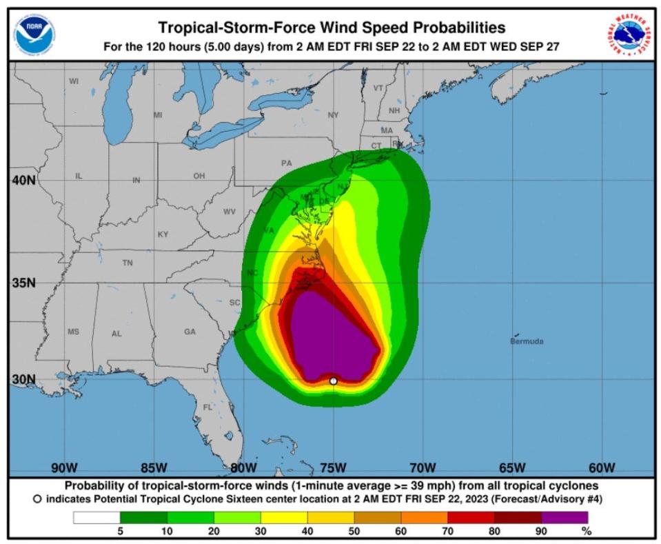
"Current thinking is (maximum) rainfall of up to an inch on the South Coast on Saturday with worst case scenario of 1-2 inches if there is a northward trend," the weather service said in its forecast discussion Friday morning.
Regardless of how much rain falls, it's likely to be a dreary weekend. Fall, by the astronomical definition, arrives early Saturday, and it will feel like it, with cool, damp and breezy conditions. The high temperature for the Providence area should reach only the low 60s on Saturday and mid 60s on Sunday. The dampness and wind will make it feel cooler.
Wind gusts up to 29mph along Rhode Island coast
The weather service is forecasting gusts of up to 29 mph along the Rhode Island coast this weekend, and it has issued a small craft advisory for Narragansett Bay and along the coast. The advisory goes into effect at 8 a.m. Saturday and continues until 8 p.m. Sunday. A gale warning will go into effect further offshore.
Strong surf could also generate rip currents.
More: Hurricane Lee recap: Coastal flooding, power outages and more. What we're watching
The system was becoming better organized off South Carolina Friday, and "already features tropical-storm-force winds, and once it forms a completely closed circulation, it will become a named tropical or subtropical storm, which has both tropical and non-tropical characteristics," Accuweather says.
For Friday, the weather service is forecasting a lot of sunshine with highs in the low 70s in the Providence area.
This article originally appeared on The Providence Journal: RI weather: Potential tropical cyclone 16 will lead to wet, dreary weekend
