What would Chumash marine sanctuary off Central Coast look like? NOAA shares vision
Eight years since it was first nominated, the federal government has shared its vision for the proposed Chumash Heritage National Marine Sanctuary.
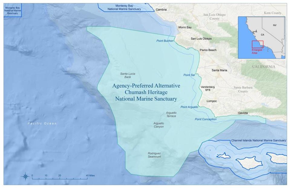
The new marine sanctuary is proposed to encompass 5,617 square miles from Hazard Canyon Reef, south of Morro Bay, to an area just north of Goleta in Santa Barbara County along California’s Pacific Ocean coastline, according to draft designation documents released Thursday morning by the National Oceanic and Atmospheric Administration’s Office of National Marine Sanctuaries.
Should it be designated, the Chumash Heritage National Marine Sanctuary would be the first new national marine sanctuary managed for biodiversity conservation in the United States since 1994.
“The Central Coast has pursued this sanctuary designation for decades, and as our oceans and our communities are facing unprecedented challenges from a changing marine environment, this draft comes at a critical time for our region,” U.S. Congressman Salud Carbajal, D-Santa Barbara, said Thursday in a prepared statement. “I am glad that we finally have a draft that puts this sanctuary’s final approval within reach.”
Implementing the management plan for the proposed sanctuary would help protect the area’s biodiversity and cultural and historical resources by developing certain marine science, education, and outreach and cultural heritage programs, according to NOAA.
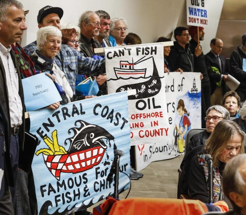
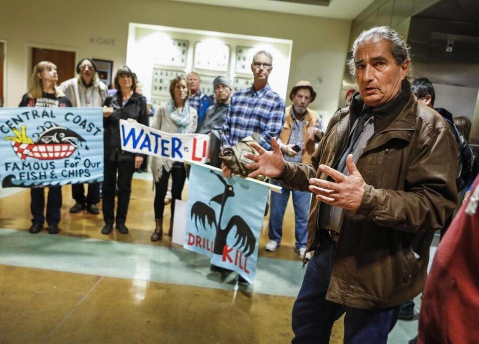
New oil, gas and mineral exploration, development and production would be prohibited within the Chumash Heritage National Marine Sanctuary.
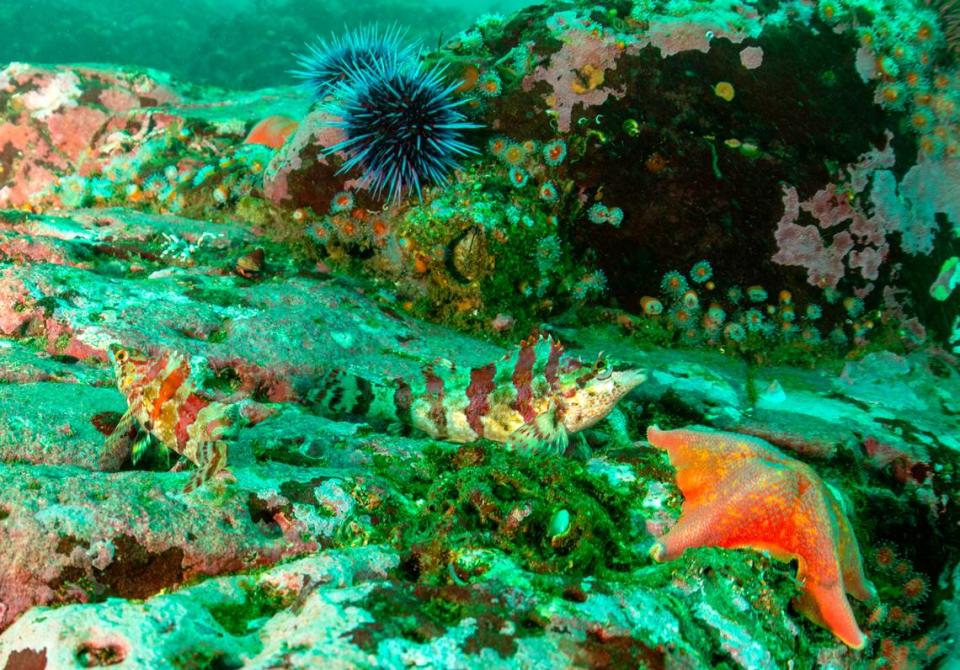
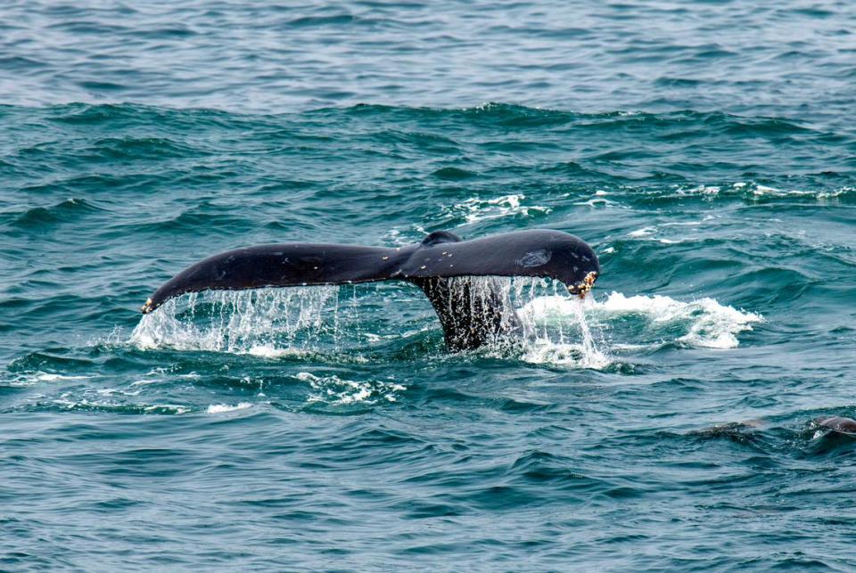
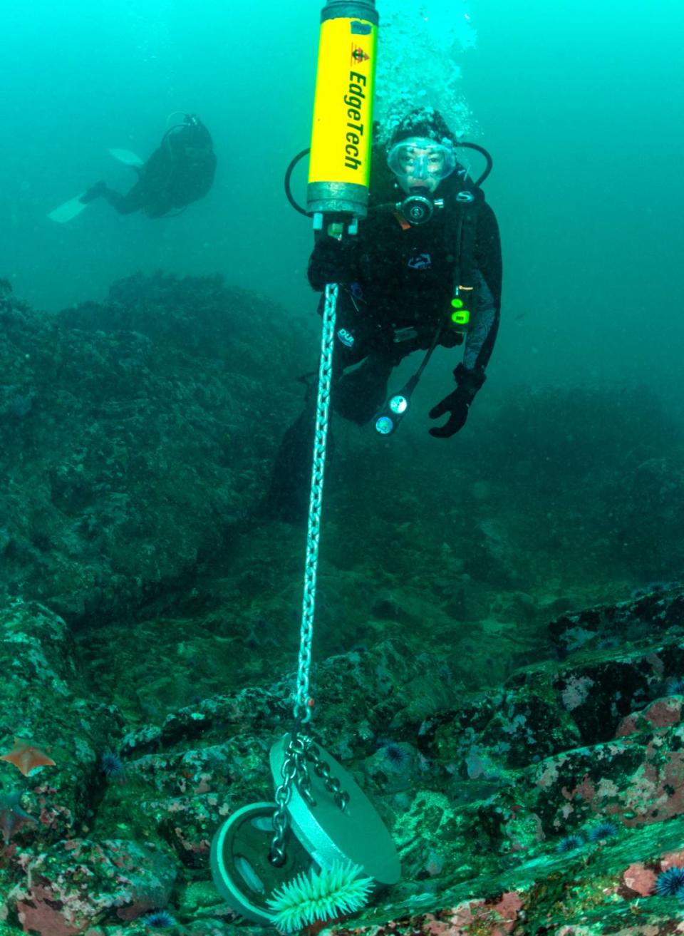
“The proposed sanctuary is rich in marine life and includes kelp forests, rocky shores, sandy beaches, a globally significant ecological transition zone and important offshore features that have been important to Chumash and other Indigenous communities for more than 10,000 years,” John Armor, director of NOAA’s Office of National Marine Sanctuaries, said in a prepared statement Thursday. “The sanctuary would also enhance conservation of numerous rare and endangered species that depend on this area, including snowy plovers, black abalone, southern sea otters, blue whales and leatherback sea turtles.”
It would also be the first-ever national marine sanctuary that includes framework for collaborative management with Native American tribal entities, the draft documents show.
The Northern Chumash Tribal Council — whose late chairman Fred Collins first nominated the area to be designated a marine sanctuary in 2015 — and other Indigenous community members will have opportunities to sit on the sanctuary’s advisory council and a new intergovernmental policy council to participate in sanctuary decision-making processes.
It took NOAA 20 months to release the draft documents after beginning the designation process in November 2021.
The draft designation documents encompass a draft management plan, draft environmental impact statement, proposed regulations and proposed boundaries for the Chumash Heritage National Marine Sanctuary.
“The coastal waters of central California are rich with precious marine life, contain critical ocean ecosystems, and are connected to the past, present, and future of the Chumash people,” U.S. Vice President Kamala Harris said Thursday in a prepared statement. “As a senator from California, I was proud to support the nomination process of the Chumash Heritage National Marine Sanctuary and today, the Biden-Harris Administration is taking the next step toward establishing the first Indigenous-proposed national marine sanctuary.”
Public comment on the draft designation documents is open until Oct. 25.
After public comment ends, NOAA will prepare the final designation documents for the sanctuary, which could include revisions from feedback from the community.
The sanctuary is then expected to be designated in 2024.
“Everyone once in a while, something really big and important happens,” California State Senator John Laird, D-Santa Cruz, said Thursday in a prepared statement. “This is one of those times. We now have the opportunity to ensure the forever protection of the beautiful Central Coast oceans and marine environment.”
What are boundaries of proposed national marine sanctuary?
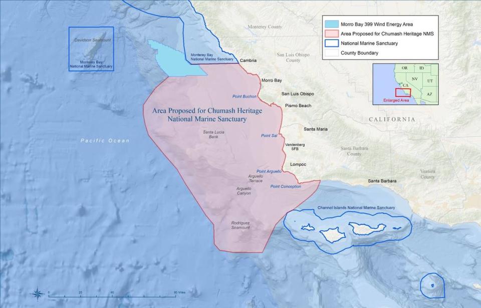
NOAA’s proposed boundaries for the Chumash Heritage National Marine Sanctuary differ from those originally proposed by the Northern Chumash Tribal Council in 2015.
The original nominators wanted the sanctuary to stretch 156 miles along the coast — from the Monterey Bay National Marine Sanctuary border off Cambria in the north to a point past Point Conception in the south, according to NOAA. Those boundaries would have encompassed 7,670 square miles.
The new boundaries proposed by NOAA on Thursday start much farther south and extend more southward.
Beginning at Hazard Canyon Reef in Montaña de Oro State Park near Los Osos, NOAA excluded the area from the Monterey Bay National Marine Sanctuary to the south of Morro Bay because that is considered a new “corridor for the industrial development associated with offshore wind energy production,” according to the agency’s website for the proposed sanctuary.
“Certain concentrations of this infrastructure may not be compatible with a national marine sanctuary depending on the number of cables and disturbance that could occur,” the website says, referencing the 20 to 30 subsea electrical transmission cables and possibly several floating substations expected to be built from the offshore wind energy development off Cambria’s coast.
“The disturbance of submerged lands and associated potential impacts on biological resources that could result from development on this scale would likely be unprecedented in a national marine sanctuary,” according to the proposed marine sanctuary designation notes regarding the offshore wind energy development.
In the documents released Thursday, NOAA proposed the Chumash Heritage National Marine Sanctuary to stretch south to Dos Pueblos Canyon in Santa Barbara County, just north of Isla Vista.
That’s farther south than what the original nominators proposed — which was roughly 25 miles up the coast near Point Conception.
Under NOAA’s vision, the national marine sanctuary would encompass “all of Gaviota State Park, as well as other high visitation state parks at Refugio and El Capitan; all of Kashtayit and Naples State marine conservation areas; and coastal and offshore resources adjacent to historical Chumash village sites at Tajiguas and Dos Pueblos,” according to the agency’s website for the sanctuary.
The marine sanctuary, according to the draft designation documents released Thursday, would stretch 50 to 60 miles west into the Pacific Ocean.
The area includes areas where the Chumash peoples lived during a time when ocean levels were 300 feet lower.
The proposed sanctuary would encompass other historically significant sites as well, such as the locations of more than 200 shipwrecks. Two of those are on the National Register of Historic Places.
The proposed Chumash Heritage National Marine Sanctuary would encompass an incredibly biologically diverse area of the California coast. It’s considered a transition zone between temperate waters from the north and warmer southern ocean currents.
“The area is recognized as a biological hotspot for birds, marine mammals, sea turtles, fishes, other marine organisms and algae, like kelp,” NOAA’s website for the proposed marine sanctuary says. “The area includes thriving ecological habitats such as kelp forests, rocky reefs and sandy beaches, as well as unique and important offshore geologic features like the Rodriguez Seamount, Santa Lucia Bank and Arguello Canyon, all home to unique and rare deep-sea corals and sponges.”
New oil production, hunting would be banned in marine sanctuary
The draft designation documents released by NOAA on Thursday prohibit certain activities within the proposed Chumash Heritage National Marine Sanctuary.
“Due to the myriad ongoing and emerging threats to the area from consumptive and non-consumptive human uses and climate change, additional protections are needed” for the marine environment in the proposed sanctuary, the draft environmental impact statement released Thursday says.
According to NOAA, hose threats include “direct and indirect impacts from offshore energy development, pollution from offshore and onshore sources, increased vessel traffic and transportation, increased coastal development and other stressors to the ecosystem that compromise its resiliency — especially acute and cumulative impacts from climate change.”
NOAA on Thursday proposed banning new oil, gas and minerals exploration, development and production within the Chumash Heritage marine sanctuary. Existing oil and gas production at platforms can continue, according to the agency.
Discharges, such as sewage, would be prohibited in the proposed marine sanctuary unless they are already exempted under federal law. This is already prohibited within three miles of California’s coastline, but designating the sanctuary would expand the ban.
“Oil discharged from vessels or from shore can cause acute toxicity in organisms, and can foul feathers of seabirds leading to illness or death,” the draft regulations published Thursday state. “Discharging other debris from vessels, by accident or on purpose, can lead to long-term impacts on resources. A chronic accumulation of plastics in marine ecosystems, for instance, can lead to an accumulation of plastic in marine organisms including those that are eventually ingested by humans.”
Disturbing the seabed, unless when anchoring a vessel, would also be prohibited under the regulations for the proposed sanctuary.
Hurting, hunting or taking a marine mammal, sea turtle or bird within the 5,600-square-mile area would also be banned unless such activities are already permitted by other agencies. Fishing, for instance, is a permitted activity.
The draft designation documents include a permit pathway to support possible additional subsea electrical transmission cables within the proposed sanctuary beyond what may be built outside of the sanctuary’s proposed boundaries to support offshore wind energy development.
The proposed regulations also specifically prohibit attracting any white shark within the sanctuary because of their function as a key species.
Great white shark cage diving has historically been a tourist draw — especially in areas of California’s coast such as the Farallon Islands — with some companies ensuring a shark encounter by using bait to attract the animals.
Additionally, any disruptive activities aside from lawful fishing around the Rodriguez Seamount would be restricted to ensure the geologically special area is protected.
The summit of the underwater mountain about 42 miles off the coast of Point Conception sits at about 2,000 feet below the ocean’s surface and is home to rare coral, sponges and other invertebrates, according to NOAA.
In its proposed regulations for the marine sanctuary, NOAA did not include any requirements for vessels to reduce speed, which studies have shown greatly reduces noise impacts on marine species and lessens the likelihood of boat collisions with animals.
NOAA also did not include any regulations on fishing in the proposed marine sanctuary area in its draft designation documents.
How would the marine sanctuary be managed?
Because the proposed Chumash Heritage National Marine Sanctuary was first nominated by the Northern Chumash Tribal Council, a key question has been how tribal and Indigenous entities would be involved in managing the sanctuary should it be designated.
While NOAA would be the primary party in charge of sanctuary actions, it would collaborate closely with tribes and Indigenous communities, federal, state and local agencies; academic institutions; organizations and businesses, according to its draft management plan released Thursday morning.
The NOAA staff would consult with federally recognized tribes for all management activities.
A Sanctuary Advisory Council made up of 15 members — including a federally recognized tribal seat and one or more Indigenous community members — would advise the NOAA staff.
An Indigenous Cultures Advisory Panel would be a working group of the Sanctuary Advisory Council. The panel would be open to individuals “with Indigenous cultural knowledge of the sanctuary area,” according to NOAA’s draft management plan.
The Indigenous Cultures Advisory Panel would coordinate with an Intergovernmental Policy Council, made up of federally recognized tribes, representatives from the state of California and possibly NOAA.
A nonprofit foundation would also be established to raise money for projects in the marine sanctuary and help coordinate communication between the managing entities, the draft management plan says.
The Santa Ynez Band of Chumash Indians is the only federally recognized Chumash tribe in the nation.

Would Chumash marine sanctuary have environmental impacts?
NOAA released a 431-page draft environmental impact statement Thursday morning detailing how designating the marine sanctuary impacts the environment and whether there would be any feasible alternative boundaries to its proposal.
It found that designating the marine sanctuary, or any of its proposed alternative boundaries, would not have any major negative impacts on the environment.
The only negative impacts the agency found from its analysis of the different marine sanctuary boundaries include those from offshore wind energy development and marine transportation.
In general, designating the proposed Chumash Heritage National Marine Sanctuary would benefit the environment because of the increased protection and management of marine resources, according to the draft environmental impact statement.
Implementing the national marine sanctuary “would provide direct benefits from implementing the proposed regulations and indirect benefits through increased information to guide resource protection decisions, coordinate resource management, and promote ocean literacy and stewardship,” the draft environmental impact statement says.
How to comment on NOAA draft designation documents
The public can comment on the draft designation documents through Oct. 25 on the Federal Register at regulations.gov under docket number NOAA-NOS-2021-0080.
Additionally, two in-person informational workshops will be held — the first on Monday, Sept. 11, at 5 p.m. at the Grover Beach Community Center, 1230 Trouville Ave. in Grover Beach. The second will be held on Tuesday, Sept. 12, at 6 p.m. at Vista Del Mar School Union, 9467 San Julian Road in Gaviota.
A virtual informational webinar will be held on Friday, Sept. 15, at 11 a.m. at meet.google.com/mfp-nkgm-gek.
Additionally, for those wishing to give verbal public comment on the draft designation documents, two in-person meetings will be held.
The first will be on Monday, Sept. 25, at 5 p.m. at the San Luis Obispo County Board of Supervisors hearing room, 1055 Monterey St. in San Luis Obispo. The second will be held on Wednesday, Sept. 27, at 5 p.m. at the Dick DeWees Community Center, 1120 West Ocean Ave. in Lompoc.
A virtual public comment meeting will be held on Thursday, Oct. 12, at 1 p.m.. To register, visit attendee.gotowebinar.com/register/7569323252287031132.

