Nor'easter to brew off East Coast, wallop region with rain and wind


It has been one rainy weekend after another in the Northeast recently, and there's a strong signal that a significant storm will develop along the East Coast this weekend, AccuWeather meteorologists say. It has the potential to become a full-fledged nor'easter, which will bring soaking rain and strong winds.
The stormy pattern will evolve from former Super Typhoon Bolaven, a violent typhoon that took a path curving east of Japan across the northern Pacific. The storm became intermingled with non-tropical storms over the Gulf of Alaska this past weekend, and stormy weather dipped into western Canada and the northwestern United States.
That will set the stage for a big dip in the jet stream over the Eastern states late this week and this weekend, AccuWeather Lead Long-Range Meteorologist Paul Pastelok said. The teleconnection of a recurving typhoon in the Pacific and its relationship to the weather pattern across the U.S. within about a week has been well-studied by AccuWeather meteorologists since the 1980s.
 |
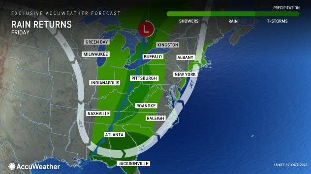
Sometimes, this configuration can lead to a major storm and a large outbreak of cool air. This time, it appears that a storm will take shape as a cold front advances from the Midwest and South Central states late this week. As the system progresses eastward and strengthens, it will also draw in more moisture.
Rain will dampen areas from the Great Lakes to the Ohio and Tennessee valleys and the southern Appalachians by Friday. Meanwhile, showers and thunderstorms will erupt from the Carolinas to Louisiana, Mississippi, Alabama and Florida.
As energy from the system pivots eastward and Atlantic moisture is tapped, a storm will form along the Carolina coast and begin to track northward, AccuWeather Chief On-Air Meteorologist Bernie Rayno said.
 |
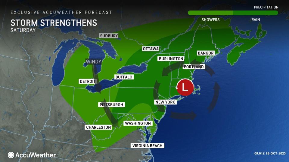
"The storm will strengthen significantly as it travels northward on Saturday night and Sunday and may even curl northwestward over the interior of New England," Rayno said. "The storm is likely to evolve into a potent nor'easter and produce a zone of heavy rain, strong winds and building seas."
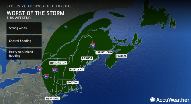
Based on the latest information available, it appears that the worst of the storm and its impacts will be focused north of New Jersey and Pennsylvania with New York City and southern New England on the southern edge of the heaviest rain.
"Which areas get hit the hardest by the effects of rain and wind will depend on the track and strength of the storm, but there is the likelihood of a thorough soaking in parts of the northeast U.S. and Atlantic Canada this weekend," AccuWeather Senior Meteorologist Adam Douty said.
 |
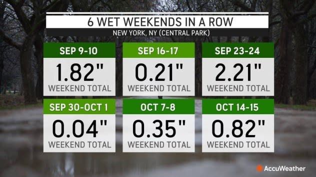
For New York City and other places in the mid-Atlantic and New England, this would be the seventh weekend in a row for rain on at least one of the weekend days. It has rained on 10 of the last 12 weekend days in New York's Central Park. The last time there was widespread dry weather in the Northeast on the weekend was way back around the Labor Day holiday. Looking back into the summer in New York City, it has rained on 50% of the weekends in August and four of the five weekends in July.
Since July 1, New York City and Boston have both received about 175% of their historical average rainfall, while farther north, in St. John, New Brunswick, the rainfall departure is nearly 250% of the historical average. Cities such as Boston and Portland, Maine, St. John and Halifax, Nova Scotia, may bear the brunt of the storm this weekend.
 |
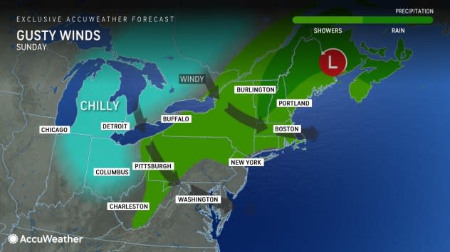
Accumulating snow may even fall over sparsely populated areas of Quebec and eastern Ontario from the storm as it matures later this weekend to early next week. It is possible that accumulating snow occurs as far to the south as the Adirondacks of northeastern New York state.
As the storm takes shape along the East Coast, travel conditions will deteriorate on the highways, and airline delays and flight cancellations will likely mount this weekend.
"The storm has the potential to lead to urban-style flooding, especially but not limited to where leaves have fallen and block storm drains," Douty said. "This new weekend storm with its wind and rain is likely to strip a lot of leaves off the trees where the canopy remains in the Northeast."
 |
Depending on the storm track and intensity, a period of coastal flooding may occur in New England with overwash from wave action. However, the storm is not likely to arrive during a period of high astronomical tides, which would add to the coastal flooding potential. Seas will be angry nonetheless and not a safe place for small craft.
A new budding tropical system in the central Atlantic that could be named Tammy will likely stay to the east of the U.S. this weekend and beyond due to the forward motion of the East Coast storm. However, some moisture that gathers in the Caribbean and the Bahamas could be drawn into the East Coast storm and may add somewhat to the rain and wind intensity.
As long as the coastal storm keeps moving along, dry air will progress across the Southeast states on Saturday and then reach portions of the central Appalachians and mid-Atlantic regions on Sunday. Conditions will likely become blustery and chilly over much of the Eastern states as the storm strengthens over New England and Atlantic Canada.
Want next-level safety, ad-free? Unlock advanced, hyperlocal severe weather alerts when you subscribe to Premium+ on the AccuWeather app. AccuWeather Alerts™ are prompted by our expert meteorologists who monitor and analyze dangerous weather risks 24/7 to keep you and your family safer.
