North Atlantic temperatures are breaking records. What does it mean?
Sea surface temperatures in the North Atlantic Ocean are significantly higher now than they have been at any time in the past 42 years. What’s going on, and what impact might this have on this year’s Atlantic Hurricane Season?
Ocean temperatures have been running high ever since March, and the end of the La Niña pattern that had persisted for the past two and a half years. It was expected that the global average temperature would rise as the wide cool region of Pacific ocean surface during La Niña transitioned to warmer waters with the development of a new El Niño. However, a somewhat unexpected response was seeing the North Atlantic Ocean break temperature records over that same time period.
The situation is unprecedented. Since March 5, 2023, the average sea surface temperature of the North Atlantic has been breaking records, reaching a high of 23.1°C as of June 18. Never before in the over 42 years of record keeping have North Atlantic sea surface temperatures reached this high.
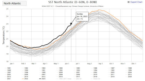
North Atlantic sea surface temperatures for year-to-date 2023 are shown in the above graph as a solid black line. Temperatures reached an average of 23.1C on June 18, 2023. That’s a half of a degree Celsius warmer than the previous record on that date, set back in 2010. (Climate Reanalyzer/Climate Change Institute at the University of Maine)
According to Brian McNoldy, a senior research associate at the University of Miami Rosenstiel School, the chances of global sea surface temperatures reaching as high as they are now, simply by chance, is only 1 in 256,000.
“This is beyond extraordinary,” McNoldy said on Twitter.
What’s going on here?
There is undoubtedly a human component to this. As greenhouse gas emissions continue to rise, more heat is being trapped in Earth’s climate system, and a significant portion of that heat is going into the oceans. There are other factors contributing to it, though.
One is Saharan dust, or in this case, the lack of it.
Easterly winds blowing off the Sahara Desert carry dust particles out over the ocean. Depending on the specific conditions, this dust can form a thick layer that’s easily visible from space. At times, it can even travel straight across the ocean to impact air quality along the east coast of North America.
When this dust is present, the particles reflect sunlight back into space, thus keeping the ocean surface slightly cooler.
However, when dust concentrations are very low, as they are now, more sunlight reaches the ocean unimpeded and the surface heats up more than usual.
Since a lot of folks are citing the anomalous current warmth in the tropical Atlantic (evident in this map below), worth noting that is substantially due to very low windblown Saharan dust. Likely to change: https://t.co/TPUPvZZdj4 https://t.co/2SfTyFRhNi
Since a lot of folks are citing the anomalous current warmth in the tropical Atlantic (evident in this map below), worth noting that is substantially due to very low windblown Saharan dust. Likely to change: Prof Michael E. Mann on Twitter: "Since a lot of folks are citing the anomalous current warmth in the tropical Atlantic (evident in this map below), worth noting that is substantially due to very low windblown Saharan dust. Likely to change: https://t.co/TPUPvZZdj4 https://t.co/2SfTyFRhNi / Twitter" Prof Michael E. Mann on Twitter: "Since a lot of folks are citing the anomalous current warmth in the tropical Atlantic (evident in this map below), worth noting that is substantially due to very low windblown Saharan dust. Likely to change: https://t.co/TPUPvZZdj4 https://t.co/2SfTyFRhNi / Twitter"
— Prof Michael E. Mann (@MichaelEMann) Prof Michael E. Mann on Twitter: "Since a lot of folks are citing the anomalous current warmth in the tropical Atlantic (evident in this map below), worth noting that is substantially due to very low windblown Saharan dust. Likely to change: https://t.co/TPUPvZZdj4 https://t.co/2SfTyFRhNi / Twitter"
Impacts of this heat
Besides the implications for climate change and sea level rise, these extreme ocean temperatures are having local impacts on ocean wildlife.
One example is the thousands of dead fish that washed up on Texas shorelines over the past few weeks.
The reason for this comes down to the amount of oxygen available in the water. Calm waters and cloudy skies apparently contributed to this fish kill. According to the Quintana Beach County Park, which is one of the beaches affected by this fish kill, the cloudy skies reduced the amount of sunlight available to microscopic phytoplankton, which produce some of the oxygen that gets dissolved in the water, and the lack of waves limited how much oxygen was captured by the ocean surface due to wave action.
The warmer waters played a significant role, though, as oxygen levels in the water drop as the temperature rises.
"Water can only hold so much oxygen at certain temperatures, and certainly we know that seawater temperatures are rising," Katie St. Clair, the manager of the sea life facility at Texas A&M University at Galveston told NPR. "It is concerning and something that needs to be monitored."
A similar situation is also brewing off the coasts of Ireland and the United Kingdom.
2023's Atlantic Hurricane Season
Another particular area of concern here is the Atlantic Main Development Region, which is where most North Atlantic tropical storms and hurricanes form.
According to Ben Noll, a meteorologist with New Zealand’s National Institute of Water & Atmospheric Research, temperatures in this area of the Atlantic are record high right now.
📈 It's official: the Atlantic Main Development Region (MDR) has reached a record high temperature* for the month of June.The MDR, a breeding ground for hurricanes, has an average temperature of 28˚C (82˚F), surpassing the previous record that was set in 2005.2005 featured... pic.twitter.com/FpdCYVGXuW
📈 It's official: the Atlantic Main Development Region (MDR) has reached a record high temperature* for the month of June.
The MDR, a breeding ground for hurricanes, has an average temperature of 28˚C (82˚F), surpassing the previous record that was set in 2005.
2005 featured… Ben Noll on Twitter: "📈 It's official: the Atlantic Main Development Region (MDR) has reached a record high temperature* for the month of June.The MDR, a breeding ground for hurricanes, has an average temperature of 28˚C (82˚F), surpassing the previous record that was set in 2005.2005 featured... pic.twitter.com/FpdCYVGXuW / Twitter"
With hotter sea surface temperatures in the Main Development Region, there comes a greater risk of powerful tropical cyclones spinning up.
“The MDR, a breeding ground for hurricanes, has an average temperature of 28˚C (82˚F), surpassing the previous record that was set in 2005,” Noll said. “2005 featured the second most active hurricane season on record. 2023 appears unlikely to be that active because of El Niño, but a busy season is well within the realm of possibility.”
As noted by Noll, with the newly-developed El Niño in the equatorial Pacific Ocean, there will be a tendency towards weaker tropical cyclones across the North Atlantic. During an El Niño, winds high above the Atlantic typically blow stronger than they do when there’s a La Niña pattern or when conditions are “in between” El Niño and La Niña. That has the effect of limiting how tall a tropical cyclone can grow, which in turn limits how strong the storm can become. Thus, El Niño years tend to have slightly weaker hurricane seasons, overall.
Such is not always the case, though. The 2005 Atlantic Hurricane Season occurred during a weak to moderate El Niño, and it still produced a total of 28 storms. From 2005 to 2019, it remained the most active hurricane season on record, and it still holds the record for the greatest number of hurricanes (15) and the greatest number of major hurricanes (7), which included four Category 5 storms — Emily, Katrina, Rita, and Wilma.
Towards the end of May, NOAA issued their outlook for the 2023 Atlantic hurricane season, forecasting a 40 per cent chance of a near-normal year for tropical storms and hurricanes. Their forecast is calling for between 12-17 named storms to develop before the season ends on November 30. Of those storms, between 5 and 9 are expected to become hurricanes, and up to 4 of those hurricanes could develop into major hurricanes (Category 3 or higher). Due to the uncertainties in how long these record-breaking ocean temperatures will last and how quickly El Niño will develop, the other 60 per cent confidence was evenly split with regards to whether this could end up as a “below average” or “above average” season.
(NOAA/NWS National Hurricane Center)
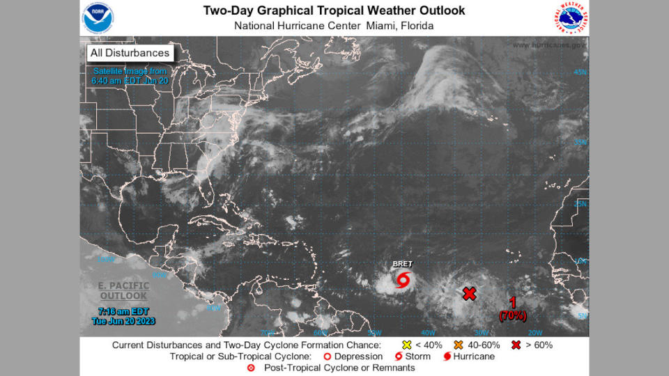
Even up until the middle of June, the only storm detected was Tropical Storm Arlene, which developed and then died off after only three days in the Gulf of Mexico.
However, as of June 19, activity is ramping up. The NWS’s National Hurricane Center is already tracking Tropical Storm Bret in the mid-Atlantic. Another disturbance (indicated by the “1” on the above satellite image) has a 70 per cent chance of developing into a tropical cyclone in the 48 hours after this article was published.
It remains to be seen exactly how Bret and this potential cyclone develop, but activity is definitely increasing and this could be a sign of a fairly active season ahead.
(Thumbnail courtesy Climate Reanalyzer/Climate Change Institute at the University of Maine)

