Northeast Florida schools to close for Nicole as St. Johns County starts evacuation
- Oops!Something went wrong.Please try again later.
The Florida Times-Union has made this article free of charge for all readers in the interest of public safety. Please consider supporting local journalism with a digital subscription.
Schools in Duval, Clay, Nassau and St. Johns counties will close Thursday to stay clear of Tropical Storm Nicole’s impact, which the National Weather Service said could trigger tornados and “life-threatening storm surge” in Northeast Florida.
Jacksonville City Hall and state and county courts across the region will also be closed Thursday and were already scheduled to be closed Friday for Veterans Day.
No evacuations are planned in Jacksonville, but Mayor Lenny Curry said shelters will open at 8 a.m. Thursday at the Legends Center, 5130 Soutel Drive, and at Landmark Middle School, 101 N. Kernan Blvd. to house people choosing to leave vulnerable properties.
People in flood-prone areas "ought to be alert. They ought to have an exit strategy," Curry said.
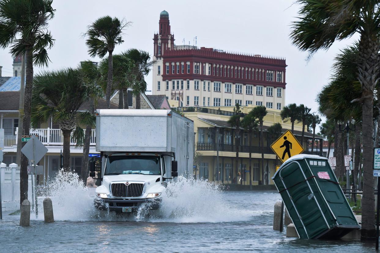
Forecasters have predicted Nicole could be accompanied by a storm surge of three to five feet above ground level in the Intracoastal Waterway and the St. Johns River between Mayport and Jacksonville. South of Jacksonville, a surge of two to four feet is expected in the St. Johns basin, with effects being felt stronger along the river's west bank, the Weather Service said.
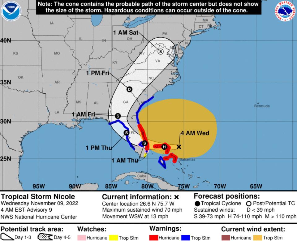
Nicole is expected to reach Florida's east coast far south of Jacksonville early Thursday, then cross the peninsula and move into Georgia early Friday.
That path will expose Jacksonville to the storm's right-front, or northeast, quadrant. While Nicole isn't an extraordinary hurricane, that position is bad news because it increases Northeast Florida's risks from storm surge and tornadoes, said Ben Nelson, a Weather Service meteorologist.
"We really think that the St. Johns River around downtown is going to have some issues with inundation," Nelson said.
City officials expect water levels in many areas "could be a little bit higher than we saw in Ian,” Jacksonville Public Works Director Steve Long told reporters during a briefing Wednesday, referencing the hurricane that brushed past Jacksonville after devastating other parts of the state in late September. He said city crews have been clearing drainage systems to help avoid water buildups.
Three to four inches of rain are expected in Clay and most of Duval and St Johns counties, with up to six inches in southern St. Johns and lighter rainfall in Nassau and northern Duval counties.
Collections of trash, yard waste and recycling that are normally done on Thursday will be rescheduled to Saturday, Curry said.
The storm is also expected to cause harmful erosion along some beaches and create deadly rip currents and dangerous conditions for boaters. Three to four inches of rain is expected across Northeast Florida by Friday.
Officials in Clay and Nassau counties announced evacuation orders for vulnerable areas — Evacuation Zone A hugging the Clay waterfront and Nassau's zones A and D in Amelia Island, Nassauville, Blackrock and neighboring areas.
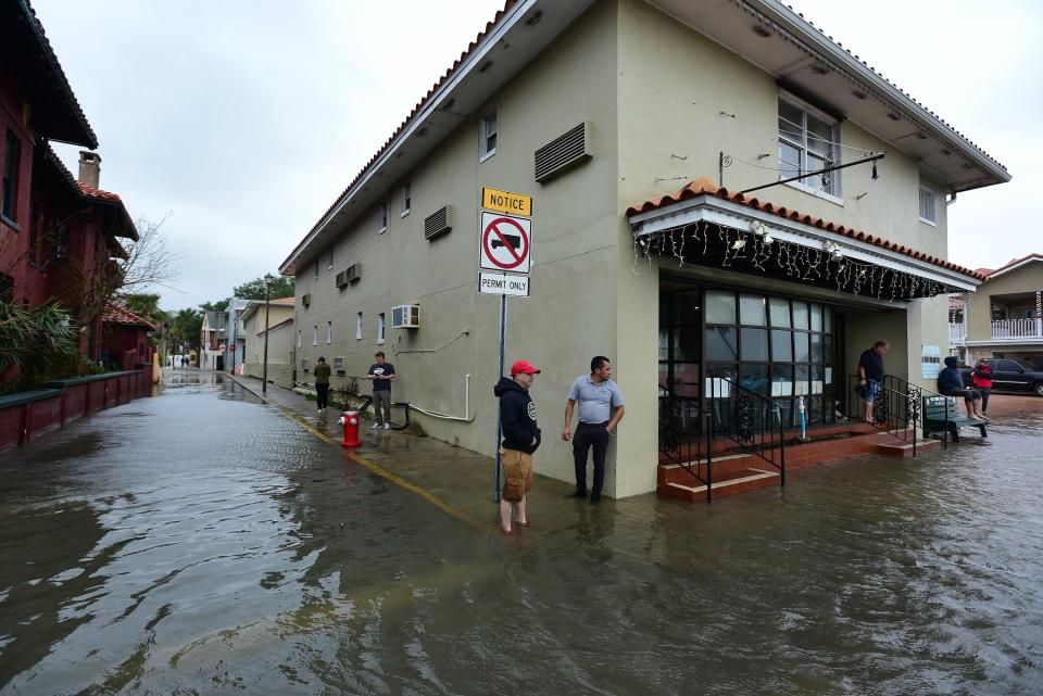
St. Johns government offices, libraries and parks closed at noon Wednesday, hours after the start of a voluntary evacuation the county announced for St. Augustine, St. Augustine Beach and waterfront or flood-prone parts of the county's coastal areas. Despite the closures, St. Johns election officials will stay at work "to meet statutory deadlines for voters to provide cure affidavits" and evidence for provisional ballots to be counted, election officials said.
An elections canvassing board meeting planned for Thursday was dropped but the board will meet Friday to review and count provisional ballots from Tuesday's general election, elections worker Jennifer Reis said in an email on behalf of Supervisor of Elections Vicky Oakes.
A storm shelter is set to open at 1 p.m. Wednesday at Solomon Calhoun Community Center, 1300 Duval St. in St. Augustine, and a shelter for people with special medical needs will open at 200 San Sebastian View in St. Augustine.
Underscoring the area's vulnerability to flooding, high tides covered low-lying parts of St. Augustine on Wednesday, while Nicole was still hundreds of miles away.
Nassau County offices will be closed Thursday too, but will also continue elections and canvassing board work.
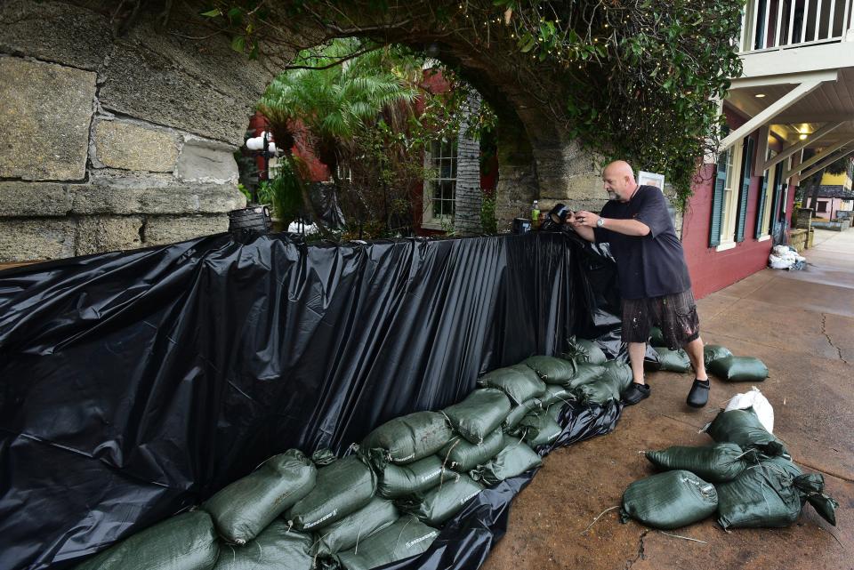
Self-fill sandbags are being distributed to Clay County residents Wednesday until 5 p.m. at 4387 Lakeshore Dr. in Fleming Island; 25 Roderigo Ave. in Green Cove Springs; 1086 Fromhart St. in Orange Park; and at Keystone Heights City Hall, where bags will be available for sand that will be at Keystone Beach.
The White House said early Wednesday that President Joe Biden had authorized the Federal Emergency Management Agency to coordinate disaster relief in a swath of counties including Duval, Nassau, Clay, St. Johns, Putnam and Bradford.
“FEMA is authorized to … provide[,] at its discretion, equipment and resources necessary to alleviate the impacts of the emergency,” a White House announcement said.
This article originally appeared on Florida Times-Union: On Nicole’s bad side, First Coast braces for storm surge, tornado risk

